Tunitas Creek
Tunitas Creek is a 6.6-mile-long (10.6 km)[2] stream in San Mateo County, California.[3] Tunitas is Spanish for "little prickly pears".
| Tunitas Creek Arroyo De Las Tunitas[1] | |
|---|---|
| Etymology | little prickly pears |
| Physical characteristics | |
| Mouth | |
• coordinates | 37.3566091°N 122.3996964°W[1] |
| Length | 6.6-mile-long (10.6 km) |
| Basin features | |
| Landmarks | Tunitas Creek Open Space Preserve |
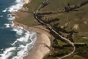
An all-weather paved county road, Tunitas Creek Road, follows the creek from its source at 1,860 feet (570 m) on Kings Mountain in the Santa Cruz Mountains to the Pacific Ocean at Tunitas Beach.[4]
History
The first European land exploration of Alta California, the Spanish Portolà expedition, traveled along the coast on its way north, camping for three days near today's San Gregorio, October 24–26, 1769. On the return journey to San Diego, the party camped near Half Moon Bay on November 16, and at Tunitas Creek on November 17. Franciscan missionary Juan Crespi noted in his diary, "This morning broke very cloudy, and as soon as we started on our way it began to rain, and in the whole three leagues (about 7.8 miles (12.6 km)) that we traveled it was falling on us. We halted on the banks of a deep arroyo."[5]
The name "Arroyo de Las Tunitas" appears on the diseños (claim maps) of both Rancho San Gregorio (1839) and Rancho Cañada Verde (1838) because it was part of the boundary between them.[6]
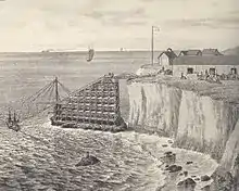
The cliffs just north of the Tunitas Creek outflow were the site of "Gordon's Chute", a ramp for sliding farm goods from the top of the cliffs to ships anchored in the rolling surf below. Gordon's Chute, named for its builder, local resident Alexander Gordon, was constructed in 1872 and lasted until 1885, when a storm blew it away.[7] Eyebolts for the chute can still be found in the cliff-face.[7]
Tributaries
References
- U.S. Geological Survey Geographic Names Information System: Tunitas Creek
- U.S. Geological Survey. National Hydrography Dataset high-resolution flowline data. The National Map Archived 2012-04-05 at WebCite, accessed March 15, 2011
- USGS, 09-20-07
- Weigel, Samantha (May 31, 2017). "Protecting Tunitas from trash: County, POST look to purchase secluded coastal property". San Mateo Daily Journal. Retrieved 1 June 2017.
- Bolton, Herbert E. (1927). Fray Juan Crespi: Missionary Explorer on the Pacific Coast, 1769-1774. HathiTrust Digital Library. pp. 237–243. Retrieved April 2014. Check date values in:
|access-date=(help) - Gudde, Erwin G. (1949). California Place Names: A Geographical Dictionary. Berkeley, California: University of California Press. p. C-347. Retrieved 2010-09-21.
- Gordon's Chute