Turangarere railway station
Turangarere was a flag station[1] on the North Island Main Trunk line,[2] in the Ruapehu District of New Zealand, in the Hautapu River valley.[3] It was 3.05 km (1.90 mi) south of Hīhītahi and 3.91 km (2.43 mi) north of Ngaurukehu.[4] Turangarere is part way up a 1 in 70 gradient from Mataroa to Hīhītahi,[5] so that it is 62 m (203 ft) above Ngaurukehu and 39 m (128 ft) below Hīhītahi.[4] The station was on a horseshoe curve, formed to avoid an even steeper gradient, by adding about 1.5 mi (2.4 km) to the route.[6] Only a single track now remains through the former station site.[7]
Turangarere railway station | |||||||||||
|---|---|---|---|---|---|---|---|---|---|---|---|
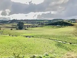 Hautapu Bridge from the horseshoe curve in 2018. A substation is at the site of Turangerere station | |||||||||||
| Location | New Zealand | ||||||||||
| Coordinates | 39.585536°S 175.732558°E | ||||||||||
| Elevation | 702 m (2,303 ft) | ||||||||||
| Line(s) | North Island Main Trunk | ||||||||||
| Distance | Wellington 270.79 km (168.26 mi) | ||||||||||
| History | |||||||||||
| Opened | 1906 | ||||||||||
| Closed | 23 October 1966 | ||||||||||
| Electrified | June 1988 | ||||||||||
| Services | |||||||||||
| |||||||||||
Name
In 1909 it was proposed to name the crossing siding Hautapu. However, it became Gardner & Son's Siding,[8] usually abbreviated to Gardners Siding,[9] which was changed to Turangaarere on 25 October 1928. The Geographical Board recognised a change from Tarangarere to Turangaarere in 1929.[10] Hīhītahi, the next settlement up the line, had its name changed from Turangaarere in 1910.[8]
History
The line from Mataroa to Turangarere was completed and equipped with a telegraph line[8] by the Public Works Department in 1906.[11] The line to the tunnel entrance to the south was in place by August 1906.[12] It was transferred to NZR on 1 July 1908.[13] Railway houses were added in 1920.[8]
Bridge
Turangarere Bridge has five 44 ft (13 m) spans to cross the Hautapu.[11] It was built under a co-operative contract by 1899. All the timber other than the maire blocks had to be brought from Taihape.[14] The river was diverted in 1905 to avoid the need for a further two bridges.[15]
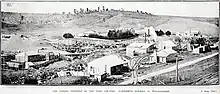
Gardner's sawmill
In 1905 Gardner and Sons had cutting-rights over a considerable area of kahikatea, rimu, matai, and totara. Initially the timber was mainly for railway construction, as the roads were too poor to take it to the then railhead at Taihape, then the terminus of the railway. The mill was powered by a 36 hp (27 kW) steam engine.[16] Gardner's applied for a private siding here in 1906[8] and had a 5-year agreement by 1 December 1908.[17]
The settlement was large enough to support a school[18] and a public hall.[19] The mill closed when the bush around it had been felled. At that time, in 1927, it employed 20.[20]
References
- "SLIPS ON RAILWAYS. MANAWATU STANDARD". paperspast.natlib.govt.nz. 19 Aug 1935. Retrieved 2020-10-06.
- Scoble, Juliet. "Names & Opening & Closing Dates of Railway Stations in New Zealand 1863 to 2010" (PDF). Rail Heritage Trust of New Zealand.
- "Ngaurukehu, Manawatu-Wanganui". NZ Topo Map. Retrieved 2020-10-06.
- New Zealand Railway and Tramway Atlas (Fourth ed.). Quail Map Co. 1993. ISBN 0-900609-92-3.
- "North Island Main Trunk Historic Area". www.heritage.org.nz. Retrieved 2020-10-04.
- "THE THROUGH TRAIN. EVENING STAR". paperspast.natlib.govt.nz. 10 Aug 1908. Retrieved 2020-10-11.
- "Historical Imagery Resource". retrolens.nz. Retrieved 2020-10-12.
- "Stations" (PDF). NZR Rolling Stock Lists. Retrieved 2020-08-10.
- "NEW ZEALAND RAILWAYS. TAIHAPE DAILY TIMES". paperspast.natlib.govt.nz. 21 Dec 1915. Retrieved 2020-10-10.
- "CORRECTING SPELLING. MANAWATU STANDARD". paperspast.natlib.govt.nz. 22 Jun 1929. Retrieved 2020-10-10.
- "WELLINGTON TO AUCKLAND. NEW ZEALAND MAIL". paperspast.natlib.govt.nz. 11 Apr 1906. Retrieved 2020-10-04.
- "LOCAL AND GENERAL. WAIRARAPA AGE". paperspast.natlib.govt.nz. 14 Aug 1906. Retrieved 2020-10-12.
- "MAIN TRUNK LINE. MANAWATU STANDARD". paperspast.natlib.govt.nz. 10 Jun 1908. Retrieved 2020-10-04.
- "DEPARTMENT OF LANDS AND SURVEY (ANNUAL REPORT". paperspast.natlib.govt.nz. 1899. Retrieved 2020-10-11.
- "The deviation at Turangarere, showing the horseshoe bend in the river, which would necessitate the building of two bridges. Auckland Weekly News". www.aucklandcity.govt.nz. 27 Apr 1905. Retrieved 2020-10-09.
- "THE TIMBER INDUSTRY OF NEW ZEALAND - REPORTS BY COMMISSIONERS OF CROWN LANDS". paperspast.natlib.govt.nz. 1905. Retrieved 2020-10-11.
- "RAILWAYS STATEMENT BY THE MINISTER OF RAILWAYS, THE HON, J. A, MILLAR". paperspast.natlib.govt.nz. 13 Oct 1909. Retrieved 2020-10-11.
- "TAIHAPE NOTES. WANGANUI CHRONICLE". paperspast.natlib.govt.nz. 20 Sep 1912. Retrieved 2020-10-11.
- "TURANGARERE NEWS. TAIHAPE DAILY TIMES". paperspast.natlib.govt.nz. 29 Oct 1915. Retrieved 2020-10-11.
- "NEWS IN BRIEF. OTAGO DAILY TIMES". paperspast.natlib.govt.nz. 15 Feb 1927. Retrieved 2020-10-11.
External links
Photos -