Twomile Creek (Kanawha River tributary)
Twomile Creek is a tributary of the Kanawha River, 4.7 miles (7.6 km) long,[5] in West Virginia in the United States. Via the Kanawha and Ohio rivers, it is part of the watershed of the Mississippi River, draining an area of 24.4 square miles (63 km2)[6] on the unglaciated portion of the Allegheny Plateau, in the city of Charleston and its vicinity.
| Twomile Creek | |
|---|---|
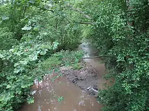 Twomile Creek in Charleston | |
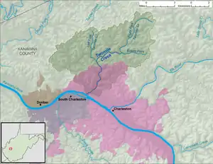 A map of Twomile Creek and its watershed | |
| Location | |
| Country | United States |
| State | West Virginia |
| County | Kanawha |
| Physical characteristics | |
| Source | Right Fork Twomile Creek |
| • location | north-northwest of Elk Hills |
| • coordinates | 38.4456513°N 81.5898468°W[1] |
| • length | 4.6 mi (7.4 km) |
| • elevation | 973 ft (297 m)[2] |
| 2nd source | Edens Fork |
| • location | northwest of Elk Hills |
| • coordinates | 38.4159296°N 81.595124°W[3] |
| • length | 2.4 mi (3.9 km) |
| • elevation | 862 ft (263 m)[2] |
| Source confluence | |
| • location | southwest of McDunn |
| • coordinates | 38.4137069°N 81.6295692°W[4] |
| • elevation | 678 ft (207 m)[2] |
| Mouth | Kanawha River |
• location | Charleston |
• coordinates | 38.3706516°N 81.6762361°W[4] |
• elevation | 568 ft (173 m)[4] |
| Length | 4.7 mi (7.6 km) |
| Basin size | 24.4 sq mi (63 km2) |
| Basin features | |
| Tributaries | |
| • right | Left Fork Twomile Creek |
| Hydrologic Unit Code | 050500080301 (USGS) |
Twomile Creek is formed approximately 1.8 miles (2.9 km) east-northeast of the unincorporated community of Guthrie by the confluence of the Right Fork Twomile Creek,[1] 4.6 miles (7.4 km) long,[5] which rises approximately 3.3 miles (5.3 km) north-northwest of the unincorporated community of Elk Hills, and flows southwestward; and Edens Fork,[1] 2.4 miles (3.9 km) long,[5] which rises approximately 1.7 miles (2.7 km) northwest of Elk Hills and flows westward. From the confluence of these forks, Twomile Creek flows westward and southward, through Guthrie, to its mouth at the Kanawha River in the city of Charleston.[7][8]
The creek is paralleled by county roads for much of its length. At Guthrie, it collects the Left Fork Twomile Creek,[9] 4 miles (6.4 km) long,[5] which rises approximately 1.9 miles (3.1 km) north-northwest of Guthrie and flows generally southward.[7]
See also
References
- Geographic Names Information System. "Geographic Names Information System entry for Right Fork Twomile Creek (Feature ID #1545720)". Retrieved 2013-11-23.
- The National Map elevation for GNIS source coordinates. Retrieved 2013-11-23.
- Geographic Names Information System. "Geographic Names Information System entry for Edens Fork (Feature ID #1538551)". Retrieved 2013-11-23.
- Geographic Names Information System. "Geographic Names Information System entry for Twomile Creek (Feature ID #1548436)". Retrieved 2013-11-23.
- United States Environmental Protection Agency. "West Virginia, Lower Kanawha Watershed". Archived from the original on 2013-11-23. Retrieved 2013-11-23.
- U.S. Geological Survey. National Hydrography Dataset, area data for Twomile Creek watershed, 12-digit Hydrologic Unit Code 050500080301. The National Map, retrieved 2013-11-23
- The National Map, accessed 2013-11-23
- West Virginia Atlas & Gazetteer. Yarmouth, Me.: DeLorme. 1997. p. 43. ISBN 0-89933-246-3.
- Geographic Names Information System. "Geographic Names Information System entry for Left Fork Twomile Creek (Feature ID #1541740)". Retrieved 2013-11-24.