Tyung
The Tyung (Russian: Тюнг) is a river in Yakutia, Russia. It is a left tributary of the Vilyuy (Lena's basin). The length of the river is 1,092 kilometres (679 mi). The area of its basin is 49,800 square kilometres (19,200 sq mi).[1]
| Tyung | |
|---|---|
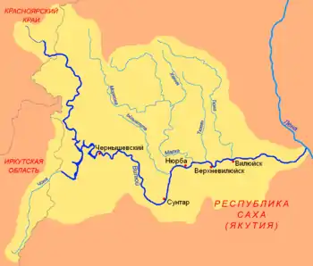 The T-shaped Chona-Vilyuy River system. | |
| Location | |
| Country | Russia |
| Physical characteristics | |
| Source | |
| • location | Central Siberian Plateau |
| Mouth | Vilyuy |
• coordinates | 63.7703°N 121.539°E |
| Length | 1,092 km (679 mi) |
| Basin size | 49,800 km2 (19,200 sq mi) |
| Basin features | |
| Progression | Vilyuy→ Lena→ Laptev Sea |
Course
The Tyung begins in the Central Siberian Plateau. When it descends into the Central Yakutian Lowland it begins to meander strongly and flows roughly southwards until it meets the Vilyuy. The Tyukyan, also a Vilyuy tributary, has its source in a swampy area near the Tyung basin.[2]
The Tyung freezes up in October and stays icebound until the second half of May to early June. Its main tributaries are the rivers Chimidikyan and Dzhippa.
See also
References
- Russian State Water Register - Tyung
- Tyukyan — Great Soviet Encyclopedia in 30 vols. / Ch. ed. A.M. Prokhorov - 3rd ed. - M, 1969-1978.
This article is issued from Wikipedia. The text is licensed under Creative Commons - Attribution - Sharealike. Additional terms may apply for the media files.