U.S. Route 62 in New Mexico
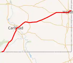
U.S. Route 62 (US 62) is part of the U.S. Highway System. US 62 travels from the United States–Mexico border at El Paso, Texas, to Niagara Falls, New York. In the U.S. state of New Mexico, US 62 extends from the Texas state line southwest of Whites City and ends at the Texas state line east of Hobbs.
| ||||
|---|---|---|---|---|
US 62 highlighted in red | ||||
| Route information | ||||
| Maintained by NMDOT | ||||
| Length | 109.710 mi[1] (176.561 km) | |||
| Existed | 1932[2]–present | |||
| Major junctions | ||||
| West end | ||||
| East end | ||||
| Location | ||||
| Counties | Eddy, Lea | |||
| Highway system | ||||
| ||||

Route description
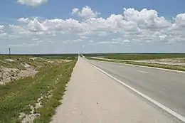
Through New Mexico, US 62 is entirely concurrent with US 180. The highway continues past Carlsbad Caverns National Park and White's City into the city of Carlsbad. In Carlsbad, US 285 joins US 62/US 180 for approximately 2.2 miles (3.5 km), then heads east to Hobbs. US 62 comes within 12 miles (19 km) of the WIPP Plant while also coming across several State Highway termini: New Mexico State Road 360 (NM 360), NM 176, NM 243, NM 529, NM 483, NM 360, and NM 8 along the 70-mile (110 km) stretch. US 62 comes into Hobbs along Marland Boulevard. After coming close to Hobbs High School's Watson Stadium, US 62 leaves Hobbs going east to the Texas–New Mexico state line.
Major intersections
| County | Location | mi[3] | km | Destinations | Notes |
|---|---|---|---|---|---|
| Eddy | | 0.000 | 0.000 | Continuation into Texas | |
| Whites City | 15.783 | 25.400 | Eastern terminus of NM 7 | ||
| Carlsbad | 33.423 | 53.789 | Western end of US 285 concurrency | ||
| 34.198 | 55.036 | Northern terminus of NM 216 | |||
| 35.291 | 56.795 | Southern terminus of NM 524 | |||
| 35.536 | 57.190 | Eastern end of US 285 concurrency | |||
| 38.687 | 62.261 | George Shoup Relief Route | |||
| | 50.686 | 81.571 | Southern terminus of NM 360 | ||
| | 53.198 | 85.614 | Northern terminus of NM 31 | ||
| | 55.322 | 89.032 | Southern terminus of NM 355 | ||
| | 62.446 | 100.497 | Western terminus of NM 243 | ||
| Lea | | 90.112 | 145.021 | Western terminus of NM 176, eastern terminus of NM 243 | |
| | 92.072 | 148.176 | Eastern terminus of NM 529 | ||
| Arkansas Junction | 97.075 | 156.227 | Southern terminus of NM 483 | ||
| | 102.015 | 164.177 | Northern terminus of NM 8 | ||
| Hobbs | 105.109 | 169.157 | |||
| 108.046 | 173.883 | Eastern terminus of NM 218 | |||
| 109.710 | 176.561 | Continuation into Texas | |||
1.000 mi = 1.609 km; 1.000 km = 0.621 mi
| |||||
References
- "Posted Route–Legal Description" (PDF). New Mexico Department of Transportation. March 16, 2010. p. 20. Retrieved October 17, 2018.
- Official Road Map of New Mexico (ZIP File) (Map). 1:1,267,200. Cartography by B.C. Broome & Louis Hesch. Santa Fe: New Mexico State Highway Department. 1932. Retrieved August 3, 2019 – via University of New Mexico RGIS.
- "TIMS Road Segments by Posted Route/Point with AADT Info; NM, US-Routes" (PDF). New Mexico Department of Transportation. June 8, 2016. pp. 7–9. Retrieved June 13, 2019.
| Previous state: Texas |
New Mexico | Next state: Texas |