U.S. Route 83 in Oklahoma
U.S. Route 83 (US-83) is a part of the U.S. Highway System that runs from the Veterans International Bridge in Brownsville, Texas north to the Canadian border, north of Westhope, North Dakota, where it continues as Manitoba Highway 83. In the U.S. state of Oklahoma, US-83 is a main north–south highway that runs from the Texas border north to the Kansas border.
| ||||
|---|---|---|---|---|
US 83 highlighted in red | ||||
| Route information | ||||
| Maintained by ODOT | ||||
| Major junctions | ||||
| South end | ||||
| ||||
| North end | ||||
| Location | ||||
| Counties | Beaver | |||
| Highway system | ||||
|
Oklahoma State Highway System
| ||||

Route description
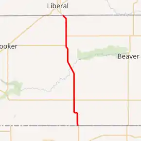
US 83 traverses the Oklahoma panhandle along the western border of Beaver County, but in this brief 37-mile (60 km) stretch it encounters no fewer than three other U.S. Highways. Approximately 10 miles (16 km) from the Texas line, US 83 intersects US 412 in the hamlet of Bryan's Corner. Continuing its journey northward, the highway crosses the Beaver River, then intersects US 64 in Turpin. US 83 north and US 64 east run concurrently for three miles (4.8 km), where US 64 turns eastward. At this intersection, US 270 west joins the highway, and together with US 83 proceeds northbound for the final six miles (9.7 km) to the Kansas line.
Major intersections
The entire route is in Beaver County.
| Location | mi | km | Destinations | Notes | |
|---|---|---|---|---|---|
| | 0.000 | 0.000 | Continuation into Texas | ||
| Bryan's Corner | |||||
| Turpin | Southern terminus of US 64 overlap | ||||
| | Northern end of US 64 overlap; southern end of US 270 overlap | ||||
| | Continuation into Kansas | ||||
1.000 mi = 1.609 km; 1.000 km = 0.621 mi
| |||||
References
External links
| Wikimedia Commons has media related to U.S. Route 83 in Oklahoma. |