Unakoti district
Unakoti district is a district of Tripura, India. This district was created on 21 January 2012 when four new districts were created in Tripura, taking the number of districts in the state from four to eight.[1]
Unakoti | |
|---|---|
District | |
 Unakoti hill | |
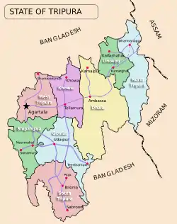 Unakoti district in Tripura | |
| State | Tripura |
| Country | India |
| Area | |
| • Total | 686.97 km2 (265.24 sq mi) |
| Population (2011) | |
| • Total | 298,574 |
| • Density | 430/km2 (1,100/sq mi) |
| Time zone | UTC+05:30 (IST) |
| ISO 3166 code | IN-TR |
| Website | http://unakoti.nic.in/ |
Kailashahar is its headquarters. The district was part of North Tripura district earlier. It is recognized for Unakoti Heritage site
Etymology
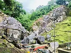
Unakoti derives its name from the Unakoti hill. Unakoti literally meaning, one less a koti in Bengali. It hosts an ancient Shaivite place of worship with huge rock reliefs celebrating Shiva.[2]
Geography
Unakoti district is surrounded by Dharmanagar subdivision, Panisagar subdivision and Kanchanpur subdivision of North Tripura district in the Northeast, East and Southeast side respectively. In the southern side, it is surrounded by Kamalpur subdivision and Longthari valley subdivision of Dhalai district. It also shares an international border with Bangladesh in the northern side.
Division
The District and divided into two sub-divisions, namely, Kailashahar subdivision and Kumarghat subdivision.
For the purpose of developmental activities it is divided into four Blocks namely Kumarghat, Pecharthal, Chandipur and Gournagar. [3]
Transport
Roadway
National Highway 8 (NH 8), running from Karimganj in Assam to Sabroom in Tripura, passes through this district.[4]
Railway
Lumding–Sabroom line of Northeast Frontier Railway passes through Unakoti district. The main station in district is Kumarghat railway station, providing connectivity to Tripura capital Agartala and Assam and other major cities of the state like Dharmanagar, Udaipur and Belonia. [5]
References
- "Four new districts, six subdivisions for Tripura". CNN-IBN. 26 October 2011. Retrieved 10 April 2012.
- "Feature". Archived from the original on 21 August 2001.
- "Unakoti District Map".
- "Rationalisation of Numbering Systems of National Highways" (PDF). New Delhi: Department of Road Transport and Highways. Archived from the original (PDF) on 4 December 2018. Retrieved 3 April 2012.
- "Kumarghat Railway station, Indian Rail Info".