Upernivik Island
Upernivik Island (Danish: Upernivik Ø) is an uninhabited[1] island in the Qaasuitsup municipality in northwestern Greenland.
| Upernivik Ø | |
|---|---|
 Upernivik | |
| Geography | |
| Location | Uummannaq Fjord |
| Coordinates | 71°16′N 52°45′W |
| Area | 540 km2 (210 sq mi) |
| Length | 30 km (19 mi) |
| Width | 24.4 km (15.16 mi) |
| Highest elevation | 1,903 m (6243 ft) |
| Highest point | Palup Qaqa |
| Administration | |
| Municipality | Qaasuitsup |
Geography
Upernivik Island is located in the Uummannaq Fjord where it is the largest island with an area of 540 km2 (208.5 sq mi).[1]
The island is very mountainous.[2] Its highest point is Palup Qaqaa, an ultra-prominent peak at 71°20′17″N 72°48′17″W reaching 1,903.47 m (6,245.0 ft).[3]
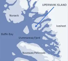 Location of Upernivik Island. |
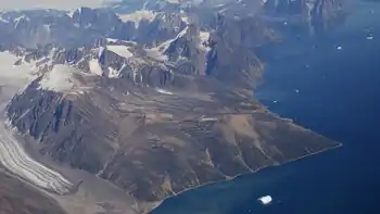 Aerial view of southwestern Upernivik Island |
See also
References
- "Norwegian University of Science and Technology". Archived from the original on 2011-06-15. Retrieved 2011-06-15.
- Nuussuaq, Saga Map, Tage Schjøtt, 1992
- GoogleEarth
This article is issued from Wikipedia. The text is licensed under Creative Commons - Attribution - Sharealike. Additional terms may apply for the media files.