Utah State Route 117
State Route 117 (SR-117) is a state highway in the U.S. state of Utah, connecting Wales and Mount Pleasant in Sanpete County. Running for 12.19 miles (19.62 km) as a two-lane highway, the road was originally placed under state jurisdiction in 1935 (as SR-30),[2] but renumbered to its current designation in 1966.
| ||||
|---|---|---|---|---|
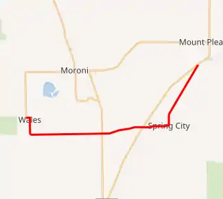
SR-117 highlighted in red | ||||
| Route information | ||||
| Defined by Utah Code §72-4-117 | ||||
| Maintained by UDOT | ||||
| Length | 12.192 mi[1] (19.621 km) | |||
| Existed | as SR-30 in 1935,[2] renumbered to SR-117 in 1966[3]–present | |||
| Major junctions | ||||
| West end | 200 West in Wales | |||
| East end | ||||
| Highway system | ||||
| ||||

Route description
State Route 117 begins on 200 North at the intersection of 200 West in Wales, travelling east for two blocks before turning south on State Street.[1] After less than 1 mile (1.6 km), it leaves the southern end of Wales, the road turns again to the east for approximately 7.4 miles (11.9 km), passing through the town of Chester and crossing US-89 before entering Spring City along 300 North.[4] In Spring City, the route turns north on Main Street, turning to the northeast after about 0.5 miles (0.80 km), continuing this direction for about 3 miles (4.8 km) before terminating at US-89 in Mount Pleasant, directly opposite the Mount Pleasant Airport.[4]
History
This route was originally part of former State Route 30, a somewhat longer route which was designated as running from Fountain Green on former SR-11 (also known as U.S. Route 89A), south through Freedom and Wales, then east through Chester and Spring City, then northeast to former SR-32 (US-89) in Mount Pleasant.[2]
In 1966, the counties in northern Utah requested that the State Road Commission designate a single route number to run east–west across that part of the state. Since Nevada's portion of the highway was numbered SR 30, Utah selected that number.[3] As a result, in November 1966 the former State Route 30 was renumbered as State Route 117. Route 117 had been freed up four months prior in July when former SR-117 from Bicknell to Boulder was absorbed by former SR-54 (now part of SR-12).[3]
In 1969, the legislature shortened the route by 9.925 miles (15.973 km), moving the western terminus from Fountain Green to Wales. After this change, the route has remained the same through the present day.[3]
Major intersections
The entire route is in Sanpete County.
| Location | mi[1] | km | Destinations | Notes | |
|---|---|---|---|---|---|
| Wales | 0.000 | 0.000 | 200 West | Western terminus | |
| Chester | 4.907 | 7.897 | |||
| West of Spring City | 7.145 | 11.499 | |||
| Mt. Pleasant | 12.192 | 19.621 | Eastern terminus | ||
| 1.000 mi = 1.609 km; 1.000 km = 0.621 mi | |||||
References
- "State Route 117 highway reference". Utah Department of Transportation. 1 Sep 2009. Retrieved 5 April 2011.
- "State Route 30 highway resolutions". Utah Department of Transportation. 1 Nov 2008. Retrieved 5 April 2011.
- "State Route 117 highway resolutions". Utah Department of Transportation. 1 Nov 2008. Retrieved 5 April 2011.
- Google (5 April 2011). "Utah State Route 117" (Map). Google Maps. Google. Retrieved 5 April 2011.