Utah State Route 13
State Route 13 (SR-13) is a state highway in northern Utah, running 32.841 miles (52.852 km) parallel to I-15 in Box Elder County from Brigham City to Riverside. Most of SR-13 is a former routing of U.S. Route 191.
| ||||
|---|---|---|---|---|
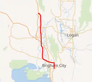
SR-13 highlighted in red | ||||
| Route information | ||||
| Defined by Utah Code §72-4-107 | ||||
| Maintained by UDOT | ||||
| Length | 33.135 mi[1] (53.326 km) | |||
| Existed | 1977–present | |||
| Major junctions | ||||
| South end | ||||
| North end | ||||
| Highway system | ||||
| ||||

Route description
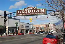
SR-13 begins at an intersection with US-89 and US-91 at the south end of Brigham City and heads north through the city, then turns west at the north end of the city to intersect I-15 and I-84. It continues northwest across the Bear River through Corinne and turns north parallel to I-15 and I-84 through Bear River City. It intersects I-15 and I-84 at Elwood and continues north around the east side of Tremonton.
North of Tremonton, SR-13 continues north through Riverside and Plymouth, turning northwest to end at another intersection with I-15 near Plymouth.[1]
History
The road from SR-1 (by 1926 US-91, now SR-90) in Brigham City north to the Idaho state line became a state highway in 1910.[2] It was initially assigned the State Route 17 designation in the 1920s,[3] but in 1927 the state legislature changed the designation to State Route 41.[4] The portion south of SR-42 (now SR-102) in Tremonton became part of U.S. Route 30S in 1926,[5] and the entire route became Utah's portion of a southern extension of U.S. Route 191 in the late 1930s.[6] A new alignment around Tremonton and Garland was defined in 1935, with the old route becoming SR-82.[7]
The SR-41 designation was dropped in 1962, as State Routes 1 to 5 were assigned to proposed Interstate Highways (in Utah law; the routes were never signed as such), and SR-41 was on the route of I-15, which was SR-1 under Utah law. However, since I-15 near Brigham City was almost complete, only the portion of SR-41 north of Riverside was assigned SR-1; the remainder was instead renumbered as an extension of SR-84, which had ended at Hot Springs Junction north of Ogden.[2] Since the original proposed alignment of I-15 would have passed east of Tremonton and Riverside, this extension of SR-84 turned east at Riverside, following present SR-30 to SR-154 (Garland Road). When SR-154 was removed from the state highway system in 1969, SR-84 was extended farther east over part of it to SR-69 (now SR-38) near Collinston. Finally, in the 1977 renumbering, the part of SR-84 between Hot Springs Junction and Brigham City was redesignated US-89, and State Route 13 was created for the portion between Brigham City and Collinston.[8]
By 1982, proposed I-15 had been moved west to its current alignment north of Tremonton, and a new SR-129 was created to connect it with Riverside along present SR-30. For continuity, SR-13 was cut back to Riverside, with the Riverside-Collinston portion also becoming SR-129. SR-13 was extended north from Riverside to I-15 at exit 392 near Plymouth in 1988, replacing what had been maintained as temporary I-15. A small realignment was made in 2008 at the SR-83 intersection in Corinne, moving SR-13 from the diagonal routing alongside the rail line to a straight north–south routing on 4800 West.[9]
Major intersections
The entire route is in Box Elder County.
| Location | mi | km | Destinations | Notes | ||
|---|---|---|---|---|---|---|
| Brigham City | 0.000 | 0.000 | Southern terminus | |||
| 1.343 | 2.161 | Western Terminus of SR-90 | ||||
| 2.872 | 4.622 | Southern Terminus of SR-38 | ||||
| 5.498– 5.728 | 8.848– 9.218 | I-15 exit 365 | ||||
| Corinne | 9.158 | 14.738 | Eastern Terminus of SR-83 | |||
| Elwood | 17.825– 18.069 | 28.687– 29.079 | I-15 exit 376; south end of I-15 Bus. and I-84 Bus. concurrencies | |||
| Tremonton | 20.176 | 32.470 | Haws Corner Junction (Crossroads); north end of I-15 Bus. and I-84 Bus. concurrencies | |||
| | 22.703 | 36.537 | Northern Terminus of SR-82 | |||
| 22.078 | 35.531 | Near Garland; former SR-154 | ||||
| Riverside | 25.250 | 40.636 | ||||
| 27.313 | 43.956 | 16800 North – Fielding | Former SR-81 | |||
| Garland | 32.960 | 53.044 | Northern terminus; Near Plymouth; I-15 exit 392; | |||
1.000 mi = 1.609 km; 1.000 km = 0.621 mi
| ||||||
See also
References
- UDOT Highway Reference, SR-13
- Utah Department of Transportation, Highway Resolutions: "Route 41". (10.9 MB), updated October 2007, accessed May 2008
- Rand McNally Auto Road Atlas, 1926
- Utah State Legislature (1927). "Chapter 21: Designation of State Roads". Session Laws of Utah.
41. From Brigham northwesterly to Corinne, thence northerly via Tremonton and Garland to the Utah-Idaho State line near Portage, Utah.
- Bureau of Public Roads & American Association of State Highway Officials (November 11, 1926). United States System of Highways Adopted for Uniform Marking by the American Association of State Highway Officials (Map). 1:7,000,000. Washington, DC: U.S. Geological Survey. OCLC 32889555. Retrieved November 7, 2013 – via University of North Texas Libraries.
- Rand McNally & Company, Texaco Road Map: Idaho, Montana, Wyoming, 1937
- Utah State Legislature (1935). "Chapter 37: Designation of State Roads". Session Laws of Utah.
Route 82. From a point on route 41 two miles east of Tremonton thence north to Garland Sugar Factory on route 41.
- Utah Department of Transportation, Highway Resolutions: "Route 84". (6.85 MB), updated November 2007, accessed May 2008
- Utah Department of Transportation, Highway Resolutions: "Route 13". (4.69 MB), updated February 2008, accessed May 2008
External links
![]() Media related to Utah State Route 13 at Wikimedia Commons
Media related to Utah State Route 13 at Wikimedia Commons