Utah State Route 20
State Route 20 (SR-20) is a state highway in southern Utah, running 20.492 miles (32.979 km) in Iron and Garfield Counties, without directly serving or connecting any cities. It serves as a truck connection between I-15 and US-89 and an access to Bryce Canyon National Park. It may also be used to travel between Salt Lake City and Phoenix, Arizona. The highway follows the route of the Old Spanish Trail.[2]
| ||||
|---|---|---|---|---|
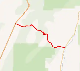
SR-20 highlighted in red | ||||
| Route information | ||||
| Defined by Utah Code §72-4-107 | ||||
| Maintained by UDOT | ||||
| Length | 20.492 mi[1] (32.979 km) | |||
| Existed | 1917 as a state highway; 1927 as SR-20–present | |||
| Major junctions | ||||
| West end | ||||
| East end | ||||
| Highway system | ||||
| ||||

Route description
SR-20 begins at I-15, Exit 95, 14 miles (23 km) north of Paragonah, and heads east and southeast through a pass between the Markagunt Plateau and the Tushar Mountains. It ends at an intersection with US-89 at Bear Valley Junction. Trucks are routed from I-15 and US-89 onto SR-20 in preference to SR-9 and SR-14 to avoid steep grades and switchbacks required to cross the Markagunt Plateau. Because of this, SR-20 is included in the National Highway System.[3] SR-20 itself is a difficult route, featuring 7% grades on the approaches to the 7,910-foot (2,410 m) summit, and oversize vehicles are required to have a pilot escort.[1][4]
History
The route of SR-20 was first used by non-Native Americans in 1864, by the settlers of Panguitch.[5] It crosses the Tushar Mountains just south of the Old Spanish Trail's crossing.
The road from SR-1 (by 1926 US-91, now SR-271) in Paragonah to SR-11 (by 1926 US-89) at Bear Valley Junction was added to the state highway system in 1917.[6] In 1927, the legislature assigned the State Route 20 designation to it,[7] and in 1953 the west end was moved north to the present junction with I-15,[6] removing Little Creek Canyon Road and Upper Bear Valley Road from the state highway system.
Major intersections
| County | Location | mi[1] | km | Destinations | Notes |
|---|---|---|---|---|---|
| Iron | Paragonah | 0.000– 0.162 | 0.000– 0.261 | Exit 95 on I-15; western terminus | |
| Garfield | Bear Valley Junction | 20.492 | 32.979 | Eastern terminus | |
| 1.000 mi = 1.609 km; 1.000 km = 0.621 mi | |||||
References
- "Route Description 0020" (pdf). Utah Department of Transportation. Retrieved 2008-01-31.
- Official Highway Map, Utah Department of Transportation, 1995 edition, coordinates I-3
- "Utah National Highway System". UDOT Data Portal. Retrieved January 22, 2019.
- "State of Utah, Secondary Highways with Additional Restrictions" (PDF). Utah Motor Carrier Division / Utah Department of Transportation. Archived from the original (PDF) on 2008-09-10. Retrieved 2007-11-17.
- "Utah History Encyclopedia". University of Utah Press. Retrieved 2008-03-11.
- Utah Department of Transportation, State Route History Archived 2007-02-25 at the Wayback Machine, accessed July 2007
- Utah State Legislature (1927). "Chapter 21: Designation of State Roads". Session Laws of Utah.
20. From Paragoonah easterly to Orton, Garfield county.