Utah State Route 274
State Route 274 is a state highway completely within Parowan in the southwestern portion of the US state of Utah that connects SR-143 with I-15. The entirety of the highway is routed along Main Street.
| ||||
|---|---|---|---|---|
| Main Street | ||||
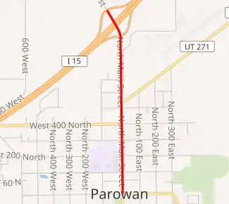
SR-274 highlighted in red | ||||
| Route information | ||||
| Defined by Utah Code §72-4-133 | ||||
| Maintained by UDOT | ||||
| Length | 1.257 mi[1] (2.023 km) | |||
| Existed | 1975–present | |||
| Major junctions | ||||
| South end | ||||
| North end | ||||
| Highway system | ||||
| ||||

Route description
The route proceeds north along a two-lane undivided highway from the intersection of Center Street (SR-143) and Main Street in the middle of Parowan in Iron County. The road exits the center of Parowan and passes the Parowan Airport before terminating at a diamond interchange at exit 78 on I-15.[2]
History
With the construction of I-15 around Parowan imminent, SR-1 was moved from old US-91 to the proposed bypass in 1968. SR-143, which had ended at SR-1 (Main Street) in Parowan, was extended north on Main Street and a planned connection to I-15 at exit 78.[3] However, plans had changed by the time I-15 was completed in 1975, and a second interchange (exit 75) served the west side of Parowan. SR-143 was instead rerouted south and west to meet I-15 there, and what had become part of SR-143 in 1968 was instead redesignated SR-274.[4]
Major intersections
The entire route is in Parowan, Iron County. [5]
| mi[1] | km | Destinations | Notes | ||
|---|---|---|---|---|---|
| 0.000 | 0.000 | Southern terminus | |||
| 1.257 | 2.023 | Northern terminus also Exit 78 on I-15 | |||
| 1.000 mi = 1.609 km; 1.000 km = 0.621 mi | |||||
References
- "State Route 274 Highway reference". Utah Department of Transportation.
- Google (June 8, 2009). "Google Maps overview of SR-150" (Map). Google Maps. Google. Retrieved June 8, 2009.
- Utah Department of Transportation, Highway Resolutions: "Route 143". (6.17 MB), updated November 2007, accessed May 2008
- Utah Department of Transportation, Highway Resolutions: "Route 274". (1.47 MB), updated December 2007, accessed May 2008
- "State Highway Map". Utah Department of Transportation. Retrieved April 1, 2008.