Vésubie
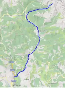
The Vésubie is a river in the southeast of France. It is a left tributary of the Var in the Maritime Alps. It is 45.9 km (28.5 mi) long.[1] Its drainage basin is 392 km2 (151 sq mi).[2] The source is in the Mercantour National park near the border with Italy. The river flows through the town of Saint-Martin-Vésubie which is a major center for hiking. It flows into the Var near Levens. One of its tributaries is the Gordolasque.
| Vésubie | |
|---|---|
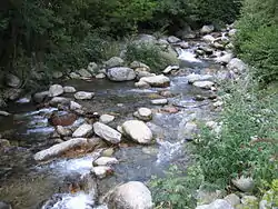 The Vésubie in Saint-Martin-Vésubie | |
 | |
| Location | |
| Country | France |
| Physical characteristics | |
| Mouth | |
• location | Var |
• coordinates | 43°51′35″N 7°11′51″E |
| Length | 46 km (29 mi) |
| Basin size | 392 km2 (151 sq mi) |
| Basin features | |
| Progression | Var→ Mediterranean Sea |
Towns along the river
References
- Sandre. "Fiche cours d'eau - La Vésubie (Y63-0400)".
- Bassin versant : Vésubie (La), Observatoire Régional Eau et Milieux Aquatiques en PACA
External links
This article is issued from Wikipedia. The text is licensed under Creative Commons - Attribution - Sharealike. Additional terms may apply for the media files.