Valdresflye
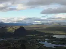
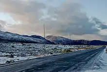
Valdresflye, also spelled Valdresflya and Valdresflyi, is a mountain plateau in the easternmost part of Jotunheimen in Øystre Slidre, Norway. The summer-only County Road 51 runs over the plateau, reaching 1,389 meters (4,557 ft) above mean sea level.[1]
| Valdresflye | |
|---|---|
| Highest point | |
| Coordinates | 61°23′28″N 8°48′40″E |
| Geography | |
| Country | Norway |
| Region | Innlandet |

Valdresflye as seen from Bitihorn
.jpg.webp)
Seen from the north in the direction of Bygdin

The plateau in October
The name
The first element is the name of the district Valdres, the last element is the finite form of fly 'flat mountain plateau'.
References
- "Nasjonal turistveg Valdresflye" (in Norwegian). Norwegian Public Roads Administration. Archived from the original on 5 October 2011. Retrieved 5 October 2011.
This article is issued from Wikipedia. The text is licensed under Creative Commons - Attribution - Sharealike. Additional terms may apply for the media files.