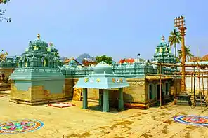
Valmikipuram
Valmikipuram (also known as Vayalpadu,Voyalpadu[2]) is a town in Chittoor district of the Indian state of Andhra Pradesh. It is the mandal headquarters. The town is known for the "Sri Pattabhi Rama temple", built by lord Jambavantha in Treta Yuga. Valmiki, the author of great epic Ramayana 'taposthan'(did tapas here).[3] Kodanda Ramaylam was built by Lord Jambavantha in Treta Yuga as a mark of his respect towards Lord Sri Rama. Uniqueness of this temple is that here Lord Sri Rama will be seen in the coronation ceremony posture as presiding deity flanked by His beloved Goddess Sita Devi and also by his brothers Laxmana, Bharatha, Shatrughna, and Lord Anjaneya. Here SriRama also called as ‘Pratapa Raama’ as he is holding sword. There is also a hill here called 'Veeranna Konda' with the shrine of Veerabhadra. It is said that the sage Valmiki sat on this hill while writing The Ramayana. Another uniqueness of this Temple Idol in this Temple is facing North and Locals says that it is the only Temple in Andhra Pradesh with North facing. Tallapaka Ananmacharya penned as many as 21 ‘sankeertanas’ in praise of the Pattabhirama Swamy deity here. Kodanda Rama Swamy Temple is holding 500 years of history, this temple well managed in Krishna Deva Raya’s period and Chola’s period. In 1997, TTD (Tirumala tirupati Devasthanams) adopted and from then temple has seen drastic growth.

Valmikipuram
Vayalpadu | |
|---|---|
town | |
.svg.png.webp) Valmikipuram Location in Andhra Pradesh, India  Valmikipuram Valmikipuram (India) | |
| Coordinates: 13.6500°N 78.6333°E | |
| Country | India |
| State | Andhra Pradesh |
| District | Chittoor |
| Mandal | Valmikipuram |
| Population (2011)[1] | |
| • Total | 17,535 |
| Languages | |
| • Official | Telugu |
| Time zone | UTC+5:30 (IST) |
Geography
Vayalpad is located at 13.6500°N 78.6333°E. It has an average elevation of 611 meters (2007 feet). Hyderabad is the state capital for Valmikipuram village. It is located around 418.7 kilometers away from Valmikipuram. The other nearest state capital from Valmikipuram is Bangalore and its distance is 136.4 km. The other surrounding state capitals are Bangalore 136.4 km., Chennai 189.6 KM., Pondicherry 229.2 km[4]Valmikipuram Sun rise time Valmikipuram village is located in the UTC 5.30 time zone and it follows Indian standard time (IST). Valmikipuram sun rise time varies 13 minutes from IST. The vehicle driving side in Valmikipuram is left, all vehicles should take left side during driving. Valmikipuram people are using its national currency which is Indian Rupee and its international currency code is INR. Valmikipuram phones and mobiles can be accessed by adding the India country dialing code +91 from abroad.
Vayalpad is located at 13.55°N 78.50°E.[5]
| Climate data for Vayalpad | |||||||||||||
|---|---|---|---|---|---|---|---|---|---|---|---|---|---|
| Month | Jan | Feb | Mar | Apr | May | Jun | Jul | Aug | Sep | Oct | Nov | Dec | Year |
| Average high °C (°F) | 27.3 (81.1) |
30.2 (86.4) |
33.4 (92.1) |
34.9 (94.8) |
35 (95) |
32.1 (89.8) |
30.2 (86.4) |
30.1 (86.2) |
29.9 (85.8) |
28.6 (83.5) |
26.8 (80.2) |
25.7 (78.3) |
30.4 (86.6) |
| Average low °C (°F) | 16.5 (61.7) |
17.4 (63.3) |
19.4 (66.9) |
22.2 (72.0) |
23.6 (74.5) |
22.8 (73.0) |
21.8 (71.2) |
21.8 (71.2) |
21.2 (70.2) |
20.2 (68.4) |
17.8 (64.0) |
15.6 (60.1) |
20.0 (68.0) |
| Average precipitation mm (inches) | 4 (0.2) |
2 (0.1) |
3 (0.1) |
28 (1.1) |
61 (2.4) |
51 (2.0) |
81 (3.2) |
73 (2.9) |
111 (4.4) |
143 (5.6) |
54 (2.1) |
32 (1.3) |
643 (25.4) |
Source : Climate[6]

References
- "Census 2011". The Registrar General & Census Commissioner, India. Retrieved 17 November 2014.
- Nair, Shantha (2014). Sri Venkateshwara. Jaico Publishing House. ISBN 978-81-8495-445-6. Retrieved 17 November 2014.
- "Chittoor District Mandals" (PDF). Census of India. pp. 464, 513. Retrieved 19 June 2015.
- "Falling Rain Genomics. Vayalpad". Fallingrain.com. Retrieved 18 March 2012.
- "Maps, Weather, and Airports for Vayalpad, India". fallingrain.com.
- http://en.climate-data.org/location/24110/”