Verknė
The Verknė (known as Galaverknė in the upper reaches; Polish: Wierzchnia) is a 77-kilometre (48 mi) stream in Lithuania. It is a tributary of the river Neman (Nemunas); their confluence is 3 km (1.9 mi) north of Birštonas.[1]
| Verknė | |
|---|---|
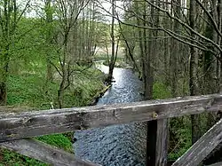 Verknė near Derionys | |
| Location | |
| Country | Lithuania |
| Physical characteristics | |
| Source | |
| • location | Near Rūdiškės |
| Mouth | Neman |
• coordinates | 54°36′41″N 24°4′7″E |
| Length | 77 km (48 mi)[1] |
| Basin size | 703 km2 (271 sq mi)[1] |
| Discharge | |
| • average | 5.55 m3/s (196 cu ft/s)[1] |
| Basin features | |
| Progression | Neman→ Baltic Sea |
Its spring is near Rūdiškės in the Trakai District Municipality where it is known as Galaverknė and passes a chain of smaller lakes. Having left the Vilkokšnis lake, the stream is known as Verknė. Aukštadvaris with a population of 977 (2011) is the only larger settlement along the river. Verknė passes the Prienai District Municipality and forms the border of the Birštonas Municipality near its mouth.
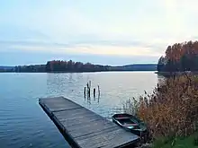
In 1960, the Verknė was impounded to create the two reservoirs with hydroelectric power stations. The largest is Aukštadvaris Reservoir (2.93 km2 (1.13 sq mi); the smaller one being Jundeliškės Reservoir.
Tourism
The Verknė is one of the cleanest streams in Lithuania and 59.4 km (36.9 mi) is popular with kayakers and good for beginners.[1] The first tour was made and described by the hydrologist Steponas Kolupaila.[2]
The stream is part of two regional parks with several protected areas: Aukštadvaris Regional Park (153.5 km2 or 59.3 sq mi) and Nemunas Loops Regional Park (240.8 km2 or 93.0 sq mi). The parks were established in 1992.[3][4]
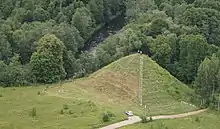
A series of 12 hillforts (piliakalnis) is located near the Verknė. Most of these forts were built or expanded between the 10th and 14th centuries.[5]
In Žydkaimis near the Vilkokšnis lake, a Jewish community was active in agriculture since the mid-19th century, even though this was banned in the Russian Empire. The community was supported in the 1930s by ORT. In 1936, the Jews owned 63% of the land in the village, despite emigration.[6]
Basin
.JPG.webp)
Total watershed is 703 km2 (271 sq mi). The average discharge is 5.55 m3/s (196 cu ft/s) with a maximum of 116 m3/s (4,100 cu ft/s).[1] The main tributaries are Alšia and Obeltis.
Right tributaries
- Balina
- Lėlelė
- Guostė
- Alšia
- Svėdubė
Left tributaries
- Strūzda
- Samė
- Adinčiava
- Vapsa
- Obeltis
- Dindžiakė
References
- Upė Verknė, Nemuno intakas. Aprašymas, informacija, vandens turizmo maršrutas, atstumai. Vandens lygis. (Lithuanian)
- Steponas Kolupaila: Mūsų vandens keliai. Kaunas 1933.
- protectedplanet.net: Aukstadvario regioninis parkas in Lithuania.
- protectedplanet.net: Nemuno kilpu regioninis parkas in Lithuania.
- Verknės upė. (S. Buchaveckas: Verknė. 1984.)
- A Jewish village in aid of Jewish farmers.
Further reading
| Wikimedia Commons has media related to Verknė. |
- Stanislovas Buchaveckas: Verknė. 1984.
- Steponas Kolupaila: Mūsų vandens keliai. Kaunas 1933. Updated version, Kaunas 1938.