Vicksburg Bridge
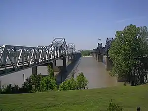
The Vicksburg Bridge is a cantilever bridge carrying Interstate 20 and U.S. Route 80 across the Mississippi River between Delta, Louisiana and Vicksburg, Mississippi.
Vicksburg Bridge | |
|---|---|
 | |
| Coordinates | 32°18′55″N 90°54′30″W |
| Carries | 4 lanes of |
| Crosses | Mississippi River |
| Locale | Delta, Louisiana and Vicksburg, Mississippi |
| ID number | 053304510900001 |
| Characteristics | |
| Design | Cantilever bridge |
| Total length | 12,974 feet (3,954 m) |
| Width | 60 feet (18 m) |
| Longest span | 870 feet (265 m) |
| Clearance below | 116 feet (35 m) |
| History | |
| Opened | February 14, 1973 |
| Statistics | |
| Daily traffic | 25,000 (2007) |
| Location | |

| |
Next to it is the Old Vicksburg Bridge.
The Vicksburg Bridge is the northernmost crossing of the Mississippi River in Louisiana open to motor vehicles.
In 2013 state officials announced projects to improve the stability of the bridge, and to install underwater radar to assist barge captains in avoiding the bridge, which had been struck by barges repeatedly since its construction.[1]
References
See also
Crossings of the Mississippi River | ||||
|---|---|---|---|---|
| ||||
This article is issued from Wikipedia. The text is licensed under Creative Commons - Attribution - Sharealike. Additional terms may apply for the media files.