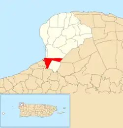
Victoria, Aguadilla, Puerto Rico
Victoria is a barrio in the municipality of Aguadilla, Puerto Rico. Its population in 2010 was 1,790. In Victoria barrio is part of the Aguadilla urban zone.[3][4][5]
Victoria | |
|---|---|
Barrio | |
 | |
 Victoria Location of Puerto Rico | |
| Coordinates: 18°24′23″N 67°08′56″W[1] | |
| Commonwealth | |
| Municipality | |
| Area | |
| • Total | 1.70 sq mi (4.4 km2) |
| • Land | 1.67 sq mi (4.3 km2) |
| • Water | 0.03 sq mi (0.08 km2) |
| Elevation | 338 ft (103 m) |
| Population (2010) | |
| • Total | 1,790 |
| • Density | 1,071.9/sq mi (413.9/km2) |
| Source: 2010 Census | |
| Time zone | UTC−4 (AST) |
History
A lot of sugar cane was grown in Victoria in the 19th century.[6]
Puerto Rico was ceded by Spain in the aftermath of the Spanish–American War under the terms of the Treaty of Paris of 1898 and became a territory of the United States. In 1899, the United States conducted its first census of Puerto Rico finding that the population of Victoria barrio was 716.[7]
| Historical population | |||
|---|---|---|---|
| Census | Pop. | %± | |
| 1980 | 2,583 | — | |
| 1990 | 2,519 | −2.5% | |
| 2000 | 2,043 | −18.9% | |
| 2010 | 1,790 | −12.4% | |
| U.S. Decennial Census[8] 1899 (shown as 1900)[9] 1910-1930[10] 1930-1950[11] 1980-2000[12] 2010[13] | |||
Sectors
Barrios (which are roughly comparable to minor civil divisions)[14] in turn are further subdivided into smaller local populated place areas/units called sectores (sectors in English). The types of sectores may vary, from normally sector to urbanización to reparto to barriada to residencial, among others.[15][16][17][18][19]
The following sectors are in Victoria barrio:[20]
Condominio Vistamar.
References
- "US Gazetteer 2019". US Census. US Government. Archived from the original on 2020-01-16. Retrieved 2020-06-24.
- U.S. Geological Survey Geographic Names Information System: Victoria barrio
- Picó, Rafael; Buitrago de Santiago, Zayda; Berrios, Hector H. Nueva geografía de Puerto Rico: física, económica, y social, por Rafael Picó. Con la colaboración de Zayda Buitrago de Santiago y Héctor H. Berrios. San Juan Editorial Universitaria, Universidad de Puerto Rico,1969.
- Gwillim Law (20 May 2015). Administrative Subdivisions of Countries: A Comprehensive World Reference, 1900 through 1998. McFarland. p. 300. ISBN 978-1-4766-0447-3. Retrieved 25 December 2018.
- Puerto Rico:2010:population and housing unit counts.pdf (PDF). U.S. Dept. of Commerce, Economics and Statistics Administration, U.S. Census Bureau. 2010. Archived (PDF) from the original on 2017-02-20. Retrieved 2019-01-08.
- "Barrios de Puerto Rico: Barrio Victoria de Aguadilla [The History of Puerto Rico through its Barrios: Victoria Barrio of Aguadilla]" (video). www.pbslearningmedia.org (in Spanish). Fundación Puertorriqueña de las Humanidades and Sistemas TV. Archived from the original on 7 September 2015. Retrieved 2 September 2020.
- Joseph Prentiss Sanger; Henry Gannett; Walter Francis Willcox (1900). Informe sobre el censo de Puerto Rico, 1899, United States. War Dept. Porto Rico Census Office (in Spanish). Imprenta del gobierno. p. 160.
- "U.S. Decennial Census". United States Census Bureau. Archived from the original on February 13, 2020. Retrieved September 21, 2017.
- "Report of the Census of Porto Rico 1899". War Department Office Director Census of Porto Rico. Archived from the original on July 16, 2017. Retrieved September 21, 2017.
- "Table 3-Population of Municipalities: 1930 1920 and 1910" (PDF). United States Census Bureau. Archived (PDF) from the original on August 17, 2017. Retrieved September 21, 2017.
- "Table 4-Area and Population of Municipalities Urban and Rural: 1930 to 1950" (PDF). United States Census Bureau. Archived (PDF) from the original on August 30, 2015. Retrieved September 21, 2014.
- "Table 2 Population and Housing Units: 1960 to 2000" (PDF). United States Census Bureau. Archived (PDF) from the original on July 24, 2017. Retrieved September 21, 2017.
- Puerto Rico:2010:population and housing unit counts.pdf (PDF). U.S. Dept. of Commerce Economics and Statistics Administration U.S. Census Bureau. 2010. Archived (PDF) from the original on 2017-02-20. Retrieved 2019-08-02.
- "US Census Barrio-Pueblo definition". factfinder.com. US Census. Archived from the original on 13 May 2017. Retrieved 5 January 2019.
- Mari Mut, José A. (28 August 2013). "Los pueblos de Puerto Rico y las iglesias de sus plazas" (in Spanish). Retrieved 19 June 2020 – via archive.org.
- "Agencia: Oficina del Coordinador General para el Financiamiento Socioeconómico y la Autogestión (Proposed 2016 Budget)". Puerto Rico Budgets (in Spanish). Archived from the original on 28 June 2019. Retrieved 28 June 2019.
- Rivera Quintero, Marcia (2014), El vuelo de la esperanza : Proyecto de las Comunidades Especiales Puerto Rico, 1997-2004 (Primera edición ed.), San Juan, Puerto Rico Fundación Sila M. Calderón, ISBN 978-0-9820806-1-0
- "Leyes del 2001". Lex Juris Puerto Rico (in Spanish). Archived from the original on 14 September 2018. Retrieved 24 June 2019.
- "Comunidades Especiales de Puerto Rico" (in Spanish). 8 August 2011. Archived from the original on 24 June 2019. Retrieved 24 June 2019.
- "PRECINTO ELECTORAL AGUADILLA 035" (PDF). Comisión Estatal de Elecciones (in Spanish). PR Government. 30 January 2019. Retrieved 21 June 2020.