Vieux Fort, Saint Lucia
Vieux Fort is a town located near the southernmost point of Saint Lucia, a Caribbean island. It is named after a fort that used to watch out towards Saint Vincent towards the south. The population is about 4,500, while the surrounding district of Vieux Fort Quarter has a total population of about 16,000.
Vieux Fort, Saint Lucia | |
|---|---|
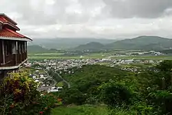 Vieux Fort | |
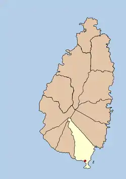 Political map of Saint Lucia showing location of Vieux Fort | |
| Coordinates: 13.728°N 60.954°W | |
| Country | |
| Quarter | Vieux Fort Quarter |
| Founded | 18th Century |
| Named for | A nearby fort |
| Government | |
| • Governing body | Vieux Fort Council |
| Elevation | 1 m (3 ft) |
| Population (2005)[2] | |
| • Total | 15,750 |
| Time zone | UTC-4 (Eastern Caribbean Time Zone (ECT)) |
| Area code(s) | 758 |
In the 18th and 19th centuries it was an important centre of the sugar industry in Saint Lucia before that industry declined.
During World War II, the Americans constructed an airfield called Beane Army Airfield. After the war it was subsequently expanded to form Hewanorra International Airport.[3]
Today, Vieux Fort is the main point of entry for Saint Lucia and also hosts a port[4] just to the south of the town. It is also a major industrial area and also hosts other places such as St Jude's Hospital and the George Odlum Stadium.
References
- http://freemeteo.com/default.asp?pid=15&gid=3576812&la=1
- http://www.stats.gov.lc
- Harmsen, Jolien; Ellis, Guy; Devaux, Robert (2014). A History of St Lucia. Vieux Fort: Lighthouse Road. p. 284,357. ISBN 9789769534001.
- Saint Lucia Air and Sea Port Authority. "www.slaspa.com". Archived from the original on 2010-03-08. Retrieved 2010-04-19.