Vinjeøra
Vinjeøra is a village in the municipality of Heim in the Trøndelag county of Norway. The village lies along the European route E39 highway at the end of the Vinjefjorden about 12 kilometres (7.5 mi) south of the municipal center of Kyrksæterøra. The village has a population of almost 300 and is located about 95 kilometres (59 mi) from the city of Trondheim. It is also about 105 kilometres (65 mi) from the city of Kristiansund.
Vinjeøra | |
|---|---|
Village | |
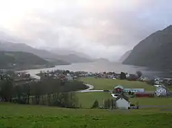 View of the village | |
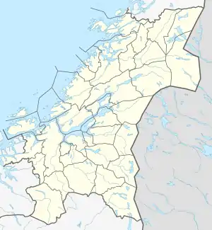 Vinjeøra Location of the village  Vinjeøra Vinjeøra (Norway) | |
| Coordinates: 63.2064°N 08.9847°E | |
| Country | Norway |
| Region | Central Norway |
| County | Trøndelag |
| District | Fosen |
| Municipality | Heim |
| Elevation | 5 m (16 ft) |
| Time zone | UTC+01:00 (CET) |
| • Summer (DST) | UTC+02:00 (CEST) |
| Post Code | 7203 Vinjeøra |
Historically, Vinjeøra was the administrative centre of the old municipality of Vinje, which became a part of Hemne municipality in 1964.
The Fjordruta hiking trail is operated by KNT, and has a number of hikes that are accessible from Vinjeøra, including Storlisetra, Sollia, and Storfiskhytta. The lake Vasslivatnet is located about 13 kilometres (8.1 mi) east of Vinjeøra. The mountain Ruten, the highest peak in Hemne, stands southeast of the village. The Vinje Church is located in the village of Vinjeøra.