Virgin Islands
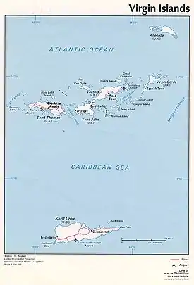
The Virgin Islands (Spanish: Islas Vírgenes) are an archipelago in the Caribbean Sea. They are geologically and biogeographically the easternmost part of the Greater Antilles,[1] the northern islands belonging to the Puerto Rico Trench and St. Croix being a displaced part of the same geologic structure. Politically, the British Virgin Islands have been governed as the western island group of the Leeward Islands, which are the northern part of the Lesser Antilles, and form the border between the Caribbean Sea and the Atlantic Ocean. The archipelago is separated from the true Lesser Antilles by the Anegada Passage and from the main island of Puerto Rico by the Virgin Passage.
 | |
| Geography | |
|---|---|
| Location | Caribbean Sea, Atlantic Ocean |
| Coordinates | |
| Archipelago | Leeward Islands |
| Insular area | United States Virgin Islands |
| Insular area | Puerto Rico |
| Overseas territory | British Virgin Islands |
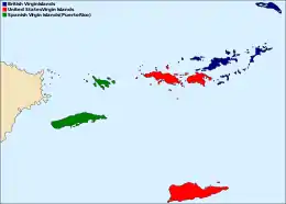
The islands fall into three different political jurisdictions:
- British Virgin Islands, a British overseas territory,
- United States Virgin Islands, an unincorporated territory of the United States,
- Spanish Virgin Islands, the easternmost islands of the Commonwealth of Puerto Rico, itself an unincorporated territory of the United States.
Etymology
Christopher Columbus named the islands after Saint Ursula and the 11,000 Virgins (Spanish: Santa Úrsula y las Once Mil Vírgenes), shortened to the Virgins (las Vírgenes). The official name of the British territory is the Virgin Islands, and the official name of the U.S. territory is the Virgin Islands of the United States. In practice, the two island groups are almost universally referred to as the British Virgin Islands and the U.S. Virgin Islands.
History
The Virgin Islands were originally inhabited by the Arawak and Carib, almost all of whom are thought to have perished during the colonial period due to enslavement, foreign disease, and mass extermination brought about by European colonists, as is the case in the rest of the Caribbean.[2]
European colonists later settled here and established sugar plantations, at least one tobacco plantation, and purchased slaves acquired from Africa. The plantations are gone, but the descendants of the slaves remain the bulk of the population, sharing a common African-Caribbean heritage with the rest of the English-speaking Caribbean.
Like mainland Puerto Rico, the Virgin Islands that belonged to Spain were ceded to the United States in 1898. The United States took possession of the islands after the signing of the armistice that put an end to military operations in the Spanish–American War.
In 1916 and 1917, Denmark and the United States, respectively, ratified a treaty in which Denmark sold the Danish Virgin Islands to the United States for $25 million in gold.
In the 1990s, a Puerto Rican tourism campaign renamed the Passage Islands as the Spanish Virgin Islands, though they are seldom identified as such on maps and atlases. They are part of the Commonwealth of Puerto Rico, located east of the main island of Puerto Rico. They are closer to St. Thomas than St. Thomas is to St. Croix.
Historical affiliations
The Virgin Islands have been under the sovereignty of several nations and groups throughout history. Below is a table which represents the affiliation of the various islands:
*Largely under control of pirates
**Coexisting claim
***Leased/shared territory
Demography
The total population of the Virgin Islands is 147,778: 104,901 in the U.S. Virgin Islands, 31,758 in the British, and 11,119 in the Spanish. Roughly three-quarters of islanders are black in the U.S. and British Virgin Islands, while the majority of inhabitants in Culebra and Vieques are Puerto Rican of European descent, with a significant Afro-Puerto Rican community. The main languages are English and Virgin Islands Creole in the U.S. and British Virgin Islands, and Spanish in the Puerto Rican territory. St. Thomas is the most populous island, with St. Croix close behind (51,634 and 50,601, respectively).
| Name | Sovereign State | Subdivisions | Area (km2) |
Population (2005 est.) |
Population density (per km2) |
Capital |
|---|---|---|---|---|---|---|
| British Virgin Islands | United Kingdom | Districts | 153.0 | 31,758 | 207.6 | Road Town |
| Spanish Virgin Islands (Puerto Rico) | United States | Barrios | 165.1 | 11,119 | 67.3 | |
| United States Virgin Islands | United States | Districts | 346.4 | 104,901 | 302.8 | Charlotte Amalie |
| Total | 511.5 | 147,778 | 288.9 | |||
Traffic control
Motor vehicles are driven on the left-hand side of the road in both the British and the U.S. Virgin Islands, although the steering wheels on most cars are located on the left side (as is the norm for drive-on-the-right localities). In the Spanish Virgin Islands, vehicles are driven on the right-hand side of the road.
See also
Citations
- Lazell, Dr James (2005). Island: Fact and Theory in Nature. University of California Press. p. 382. ISBN 9780520931596.
- Pereña, Luciano (1992). Genocidio en América. Madrid: Editorial MAPFRE. p. 351. ISBN 84-7100-453-4.
General sources
- Colin Thomas, J.; Allard, William Albert; Wolinsky, Cary (February 1981). "Paradise Comes of Age: The U.S. Virgin Islands". National Geographic. Vol. 159 no. 2. pp. 225–243.
External links
| Wikimedia Commons has media related to Virgin Islands. |
| Wikivoyage has a travel guide for Virgin Islands. |
| Wikisource has original text related to this article: |
- BVI.gov: British Virgin Islands government website
- U.S. Office of Insular Affairs: United States Virgin Islands government website
- Digital Library of the Caribbean: University of the Virgin Islands information
| |||||||||||||||||||||
| |||||||||||||||||||||
| |||||||||||||||||||||
| |||||||||||||||||||||
| |||||||||||||||||||||
| |||||||||||||||||||||
| |||||||||||||||||||||
.svg.png.webp)
| Authority control |
|---|