Virginia State Route 47
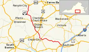
State Route 47 (SR 47) is a primary state highway in the U.S. state of Virginia. The state highway runs 61.09 miles (98.31 km) from U.S. Route 1 and US 58 Business in South Hill north to US 460 Business in Pamplin City, Virginia. SR 47 passes through Southside Virginia, where the highway connects the towns of Chase City in Mecklenburg County and Drakes Branch and Charlotte Court House in Charlotte County.
| ||||
|---|---|---|---|---|
 | ||||
| Route information | ||||
| Maintained by VDOT | ||||
| Length | 61.09 mi[1][2][3] (98.31 km) | |||
| Existed | July 1, 1933[4]–present | |||
| Tourist routes | ||||
| Major junctions | ||||
| South end | ||||
| North end | ||||
| Location | ||||
| Counties | Mecklenburg, Charlotte, Prince Edward, Appomattox | |||
| Highway system | ||||
| ||||
The entire length of SR 47 is a Virginia Byway.
Route description
_at_Gregory_Lane_in_Drakes_Branch%252C_Charlotte_County%252C_Virginia.jpg.webp)
SR 47 begins at the intersection of Mecklenburg Avenue and Atlantic Street in the center of South Hill. Mecklenburg Avenue heads north as US 1 and south as US 1 and US 58 Business. US 58 Business also heads east on Atlantic Street. SR 47 heads west as Atlantic Street to the western town limit of South Hill. The state highway passes through several small communities, including North View, Wightman, and Drapersville, as it traverses northern Mecklenburg County on top of the drainage divide between the Meherrin River to the north and the Roanoke River to the south. SR 47 enters the town of Chase City as Second Street. In the center of town, Second Street intersects Main Street. Second Street continues west as SR 49 and SR 92. SR 92 heads south on Main Street, while SR 47 turns north and runs concurrently with SR 49 to the north town limit. There, SR 49 continues north toward Victoria while SR 47 turns northwest, again closely following the drainage divide.[1][5]
SR 47 continues into Charlotte County as Craftons Gate Highway, named for the hamlet where the state highway intersects US 15 and US 360 (Kings Highway). The highway continues north and serves as Main Street in the town of Drakes Branch, where the highway crosses Twittys Creek and meets the western end of SR 59 (Gethsemane Church Avenue). SR 47 leaves the town as Tollhouse Highway and crosses Roanoke Creek before reaching Charlotte Court House. The state highway enters the county seat as Lagrande Avenue and has a very short concurrency with SR 40, which follows David Bruce Avenue to the west and George Washington Highway to the east. SR 47 exits Charlotte Court House as Thomas Jefferson Highway. The highway crosses over Norfolk Southern Railway's Altavista District rail line at the hamlet of Cullen. At County Line Road, SR 47 begins to follow the boundary between Charlotte and Prince Edward counties. The state highway has brief stretches entirely within one of the counties before continuing to serve as the county line as the highway closely parallels Norfolk Southern's Blue Ridge District.[2][5] SR 47's path along the county line ends when the highway enters Appomattox County just south of the town of Pamplin City, where the Blue Ridge District merges with the Farmville Belt Line coming from the east. The state highway passes under the two railroad tracks just before reaching its northern terminus at US 460 Business. US 460 Business connects with US 460, which heads east toward Farmville and west toward Appomattox.[3][5]
Major intersections
| County | Location | mi[1][2][3] | km | Destinations | Notes |
|---|---|---|---|---|---|
| Mecklenburg | South Hill | 0.00 | 0.00 | ||
| Chase City | 21.63 | 34.81 | Southern end of SR 49 concurrency | ||
| 22.89 | 36.84 | Northern end of SR 49 concurrency | |||
| Charlotte | Crafton Gate | 31.13 | 50.10 | ||
| Drakes Branch | 39.77 | 64.00 | Southern terminus of SR 59 | ||
| Charlotte Court House | 44.04 | 70.88 | Southern end of SR 40 concurrency | ||
| 44.14 | 71.04 | Northern end of SR 40 concurrency | |||
| Appomattox | Pamplin City | 61.09 | 98.31 | ||
1.000 mi = 1.609 km; 1.000 km = 0.621 mi
| |||||
References
- "Daily Traffic Volume Estimates Jurisdiction Report: Mecklenburg County" (PDF). Virginia Department of Transportation. 2009. Retrieved 2011-06-01.
- "Daily Traffic Volume Estimates Jurisdiction Report: Charlotte County" (PDF). Virginia Department of Transportation. 2009. Retrieved 2011-06-01.
- "Daily Traffic Volume Estimates Jurisdiction Report: Appomattox County" (PDF). Virginia Department of Transportation. 2009. Retrieved 2011-06-01.
- "New Numbers of Va. Highways Effective July 1". The Richmond Times-Dispatch. May 10, 1933. p. 5. Retrieved January 21, 2020 – via Newspapers.com.

- Google (2011-06-01). "Virginia State Route 47" (Map). Google Maps. Google. Retrieved 2011-06-01.
External links
| Wikimedia Commons has media related to Virginia State Route 47. |
| < SR 201 | Spurs of SR 20 1923–1928 |
none |
| < SR 303 | District 3 State Routes 1928–1933 |
SR 305 > |
| < SR 433 | District 4 State Routes 1928–1933 |
SR 435 > |
