Wadi Auja
Wadi Auja (Arabic: وادي العوجا), also spelled Ouja,[1] known in Hebrew as Nahal Yitav (Hebrew: נחל ייט"ב) is a valley or stream (Arabic: وادي wādī, "wadi"), in the West Bank, originating near the Ein Samia spring and flowing to Al-Auja near Jericho before it runs into the Jordan River.
Name
"Al-auja" means "the meandering one". This should not to be confused with the Yarkon River in which flows to the Mediterranean Sea in Tel Aviv, known in Arabic by the name "Nahr al-Auja". During World War I this coincidence led to the term of "the line of the two Aujas" referring to a strategic line connecting the two river valleys.[2] The Hebrew name is based on the Israeli settlement Yitav, founded in 1970 on the northern river bank, next to the Palestinian village of Al-Auja. "Yitav" is an acronym for Yad Yitzhak Tabenkin.[3]
Geography
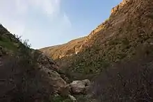
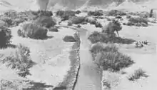
Wadi Auja is 35 kilometers long and sets the boundary between the Judean Desert and the eastern hillslopes of Samaria. It has a drainage area of 200 square kilometers and descends from a height of approximately 1000 meters above sea level to -315 meters below sea level, where it flows into the Jordan River. The stream starts at Ein Samia, on the eastern slopes of Mount Hazor and flows eastward. Before its arrival to the Jordan Rift Valley, it forms a deep and steep gorge, some 3 kilometers long. In this area some waterfalls are formed.[3] Ein Samia has been diverted to provide water to Ramallah, some 20km away, providing around 30% of the city's needs, and leaving most of the Wadi dry throughout the year.[4] The Auja Spring produces an estimated 9 million cubic metres of water annually, which creates a small oasis that attracts thousands of tourists a year, as well as providing for the farmers of Auja village.[5]
The gorge section of the river is a natural reserve, where rows of clifts are exposed and inside them a variety of rare birds of prey and perennial plants can be found.[3]
History
The area was occupied by Israel in 1967.
Today, Wadi Auja is a route used by Palestinian hikers. It is quieter and more isolated than the popular routes hiking routes such as Wadi Qelt.[4] The wadi is used by many Bedouin shepherds.
See also
References
- Gafny, Sarig; Talozi, Samer; Al Sheikh, Banan; Ya’ari, Elizabeth (May 2010). "Towards a Living Jordan River: An Environmental Flows Report on the Rehabilitation of the Lower Jordan River" (PDF). ecopeaceme.org. EcoPeace / Friends of the Earth Middle East (FoEME). Archived (PDF) from the original on 2018-12-20. Retrieved 2018-12-20.
- H. S. Gullett (1923). The Australian Imperial Force in Sinai and Palestine, 1914-1918 (PDF). Sydney: Angus & Robertson Ltd. p. 487. Retrieved 16 September 2015.
Allenby did not hesitate. His original objective had been the "line of the two Aujas" from the Nahr Auja, which falls into the Mediterranean above Jaffa, to the Wady Auja, a little stream which, bursting from springs in the desert foot-hills above the Jordan valley, flows eastwards to the Jordan River about ten miles north of the Dead Sea.
- Sefi Ben Yossef (2001). The New Israel Guide: Judean Desert and Dead Sea Valley. pp. 169–171. ISBN 965-07-0900-2.
- Szepesi, Stefan (2012). Walking Palestine: 25 Journeys Into The West Bank. Oxford: Signal. p. 201. ISBN 978-1-908493-61-3.
- "Auja Environmental Center". EcoPeace Middle East. Retrieved 5 December 2016.
External links
 Media related to Wadi Auja at Wikimedia Commons