Wadi al-Rummah
Wadi Al-Rummah or ar-Rummah (ar: وادي الرمة) is one of the Arabian Peninsula's longest river valleys, at a length of almost 600 km (370 mi). Now mostly dry and partly blocked by encroaching sand dunes, the wadi arises near Medina at Jibāl al Abyaḑ (Al-Abyad Mountain, or The White Mountain). It heads towards the north-east, connecting to several smaller wadis, like Mohalla Wadi and Murghala Wadi to the north and Jifn Wadi and Jarir Wadi to the south. It ends at Thuayrat Dunes of the ad-Dahna Desert in Al-Qassim Province near Buraidah.
The wadi then sinks beneath the sand dunes, where it is called Mistewy Wadi. It emerges on the other side of the desert as Wadi Al-Batin (approx. 425 km (264 mi)), which continues towards the north-east and forms the western boundary of Kuwait. It empties finally into the Persian Gulf.[1][2]
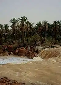
The valley is wide, for it was once a major river valley. According to Dr. Abdullah Al-Musnad from the University of Qassim, about 10,000 years ago it was a river flowing from Medina to the Persian Gulf, with a total length of 1,200 km (750 mi). Periods of drought and the movement of sand at Althwairat and Dahna led to the course of the valley being cut into three parts: Wadi Al-Rummah (the longest, at 600 km (370 mi)), Wadi Aloddi (45 km (28 mi)), and Wadi Al-Batin (450 km (280 mi)). Geological studies show that Wadi Al-Rummah flows at full capacity about three times every 100 years. It flowed most recently in 1945, 1982, 1987, 2004, 2008 and 2018. In 1818, the river valley was flooded for 40 days, in 1838 for 22 days, in 1987 and 2008 for 17 days. In 1838 the wadi overflowed, creating a 200-square-mile (520 km2) lake that persisted for two years and attracted water birds which were rarely seen in the valley.[3]
References
- I.E.S. Edwards, C.J.Gadd, and N.G.L. Hammond, "Prolegomena and prehistory", The Cambridge Ancient History, Volume I, Part I, Cambridge University Press, 1970, p. 62.
- Helen Chapin Metz, ed. (1992). "Topography and Natural Regions". Saudi Arabia: A Country Study. U.S. Library of Congress. Retrieved 2011-01-22.
- alriyadh.com – Wadi Al-Rummah Flooding, November 2008. Google translation
| Wikimedia Commons has media related to Category:Wadi al-Rummah. |
Further reading
- Farouk El-Baz (Boston University), "A river in the desert", Discover, July 1993.
External links
- countrystudies.us – Saudi Arabia: Topography and Natural Regions (Source: U.S. Library of Congress)
- youtube.com – Flow in November 2008 between Unaizah and Buraidah, Qassim province
- mekshat.com – Photo of 2008 flow