Wamba River
The Wamba River is a river in the Democratic Republic of the Congo (DRC) and Angola. It arises at an elevation of around 3,250 feet (990 m) as the confluence of several small streams in the Lunda Norte Province of Angola, a region of low hills and shallow ravines.[1] In Angola it is known as the Uamba River.
| Wamba River | |
|---|---|
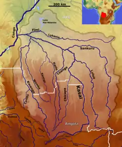 The Kasai River basin with the Wamba River (Center left) | |
| Location | |
| Countries | |
| Physical characteristics | |
| Source | |
| • location | Lunda Norte Province, Angola |
| • elevation | 3,250 feet (990 m) |
| Mouth | |
• location | Bandundu Province, Democratic Republic of the Congo |
• elevation | 1,023 feet (312 m) |
| Length | 880 kilometres (550 mi) |
It flows northward, where it forms a section of the Angola/DRC border, then for most of its length runs through the Bandundu Province to its confluence into the Kwango River at an elevation of 1,023 feet (312 m).[2]
Location
| Point | Coordinates (links to map & photo sources) |
Notes |
|---|---|---|
| Angola source | 8.635°S 18.62083°E | |
| Angola/DRC border | 8.0625°S 18.0945°E | |
| Kwango River confluence | 3.9144°S 17.1889°E |
References
- "Wamba river source". Google Maps. Google. Retrieved 21 April 2018.
- "Wamba, Kwango confluence". Google maps. Google. Retrieved 21 April 2018.
This article is issued from Wikipedia. The text is licensed under Creative Commons - Attribution - Sharealike. Additional terms may apply for the media files.