Werra
The Werra (German pronunciation: [ˈvɛʁa]), a river in central Germany, is the right-bank headwater of the Weser. Weser is a synonym in an old dialect of German. The Werra has its source near Eisfeld in southern Thuringia. After 293 kilometres (182 mi) the Werra joins the river Fulda in the town of Hann. Münden, forming the Weser.
| Werra | |
|---|---|
 | |
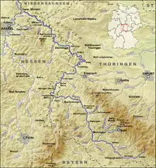 Course of the Werra | |
| Location | |
| Country | Germany |
| States | |
| Physical characteristics | |
| Source | |
| • location | on the Eselsberg and Bleßberg |
| • coordinates | 50°29′59″N 10°57′53″E |
| • elevation | 797 m above sea level (NN) |
| Mouth | |
• location | confluence with the Fulda in Hann. Münden to form the Weser |
• coordinates | 51°25′16″N 9°38′57″E |
• elevation | 116.5 m above sea level (NN) |
| Length | 299.6 km (186.2 mi) [1] |
| Basin size | 5,496 km2 (2,122 sq mi) [2] |
| Discharge | |
| • location | am Pegel Meiningen[3] |
| • average | 14.0 m3/s (490 cu ft/s) |
| Discharge | |
| • location | Vacha[3] |
| • average | 23.6 m3/s (830 cu ft/s) |
| Discharge | |
| • location | Gerstungen[3] |
| • average | 30.9 m3/s (1,090 cu ft/s) |
| Discharge | |
| • location | Frankenroda[3] |
| • average | 40.6 m3/s (1,430 cu ft/s) |
| Discharge | |
| • location | Allendorf[3] |
| • average | 46.5 m3/s (1,640 cu ft/s)
|
| Basin features | |
| Progression | Weser→ North Sea |
| Landmarks |
|
| Tributaries | |
| • left | Ulster, Felda, Wehre |
| • right | Schleuse, Hasel, Hörsel |
| Navigable | 89 km (55 mi); motor boats in places, but not throughout |
Its valley, the Werratal, has many tributaries and is a relative lull between the Rhön Mountains and the Thuringian Forest.
Its attractions include Eiben Forest near Dermbach, an unusual sandstone cave at Walldorf, the deepest lake in Germany formed by subsidence (near Bernshausen), and the "Krayenburg", the ruins of a castle.
Its towns and main settlements are Hildburghausen, Meiningen, Bad Salzungen, Tiefenort, Merkers-Kieselbach, Heringen, Philippsthal, Gerstungen, Wanfried, Eschwege, Bad Sooden-Allendorf, Witzenhausen and Hannoversch Münden.
Gallery
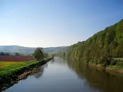
 The Werra near Treffurt
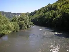 The Werra near Creuzburg
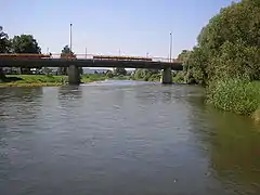
 The Werra in Eschwege
See also
References
- Messung über Geopfad (kmz, 66 kB). Die Werte von 292,1 km (ohne Quellbäche) bzw. 298,7 km (über Quelle am Eselsberg) wurden um 0,9 km nach oben korrigiert, da laut hessischer Stationierung die Ulstermündung an km 161,6 liegt, im Geopfad jedoch an 160,7.
- Environmental map service of Lower Saxony (Umweltkartendienst des Niedersächsischen Ministeriums für Umwelt, Energie und Klimaschutz)
- Gewässerkundliches Jahrbuch Weser-Ems 2005 - PDF, 6,7 MB
External links
 Media related to Werra at Wikimedia Commons
| Authority control |
|
|---|