Western Cascades
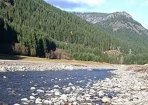
The Western Cascades is a region of the U.S. state of Oregon between the Willamette Valley and the High Cascades. Deposits of Western Cascades age are also found in adjacent southwest Washington state. The range contains many extinct shield volcanoes, cinder cones and lava flows. The range is highly eroded and heavily forested.
| Western Cascades | |
|---|---|
 The Western Cascades have been highly eroded by rivers | |
| Geography | |
 Western Cascades | |
| Country | United States |
| State | Oregon |
Geology
The region was volcanically active from approximately 35 to 17 million years ago. The province is characterized as an older, deeply eroded volcanic range lying west of the more recent snow-covered High Cascade Range. They range in elevation from 1,700 feet (520 m) on the western margin to 5,800 feet (1,800 m) on the eastern margin. The Western Cascades began to form 40 million years ago with eruptions from a chain of volcanoes near the Eocene shoreline. As the regional angle of subduction steepened, volcanic activity gradually shifted to the east in the Miocene and Pliocene.[1]
The Western Cascades are made up almost entirely of slightly deformed and partly altered volcanic flows and pyroclastic rocks which range in age from late Eocene to late Miocene. These rocks have been heavily dissected by erosion and the only evidence remaining of the many volcanoes from which they were erupted are occasional remnants of volcanic necks or plugs which mark former vents. There are also minor Pliocene to Pleistocene intracanyon lavas derived from the High Cascades or rare local vents. From youngest to oldest, the Western Cascade Range consists of four main units:[1]
- 0- to 4-million-year-old intracanyon basalt and basaltic andesite flows from the High Cascade Range.[1]
- 4- to 9-million-year-old basalt and basaltic andesite flows with lesser amounts of andesite and dacite. These rocks which cap the highest Western Cascade ridges were erupted prior to uplift and faulting along the east margin of the Western Cascade Range. This unit is compositionally identical to unit 1 and other rocks of the High Cascade Range, and therefore was probably erupted from vents in and adjacent to the High Cascades.[1]
- 9- to 18-million-year-old basalt, basaltic andesite, and andesite lavas with lesser amounts of dacite tuffs and lavas.[1]
- 18- to 40-million-year-old silicic tuffs and lavas. Units 3 and 4 were erupted from many vents west of known High Cascade volcanic centers, although some of these older vents may be buried beneath the High Cascade Range.[1]
Notable vents
| Name | Elevation | Location | Last eruption | |
| meters | feet | Coordinates | ||
| Armet Creek[2] | - | - | - | ~0.56 million years ago |
| Battle Ax Mountain[2][3] | - | - | 44°54′N 122°12′W | 1-2 million years ago |
| Crescent Mountain[2] | - | - | - | - |
| Harter Mountain[2] | - | - | - | - |
| High Prairie[2] | - | - | - | ~1.98 million years ago |
| Iron Mountain[2] | - | - | - | - |
| Snow Peak[2] | - | - | - | ~3 million years ago |
| Three Pyramids[2] | - | - | - | - |
References
Portions of this article include public domain text from the USFS Deschutes & Ochoco National Forests - Crooked River National Grassland.
- "Geomorphic Provinces - Cascades Province - Western Cascades". Deschutes & Ochoco National Forests - Crooked River National Grassland. United States Forest Service. 2005-03-25. Archived from the original on 2005-04-09. Retrieved 2008-05-14.
- Wood, Charles A.; Kienle, Jűrgen, eds. (1993). Volcanoes of North America. Cambridge University Press. pp. 169–170. ISBN 0-521-43811-X.
- "Battle Ax Mountain, Oregon". Volcano World. Retrieved 2007-05-17.
Further reading
- Du Bray, E.A.; John, D.A.; Sherrod, D.R.; Evarts, R.C.; Conrey, R.M.; Lexa, J. (2006). Geochemical database for volcanic rocks of the Western Cascades, Washington, Oregon, and California. Reston, Virginia: United States Geological Survey. p. 49. ISBN 1-4113-0929-4.