White River (White Lake)
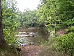
The White River is a 23.6-mile-long (38.0 km)[3] river located on the western side of the Lower Peninsula of the U.S. state of Michigan. Its source is the Oxford Swamp in Newaygo County. The rural town of Hesperia borders the river.[4]
| White River | |
|---|---|
 | |
| Physical characteristics | |
| Source | |
| • location | Monroe Township, Newago County, Michigan |
| • coordinates | 43.68001°N 85.7381°W[1] |
| Mouth | |
• location | White Lake, Michigan |
• coordinates | 43.42251°N 86.33701°W[2] |
| Basin size | 470 sq mi (1,200 km2) |
| Discharge | |
| • average | 450 cubic feet per second (13 m3/s) |
| • minimum | 220 cubic feet per second (6.2 m3/s) |
| • maximum | 1,834 cubic feet per second (51.9 m3/s) |
| Basin features | |
| Cities | White Cloud, Hesperia, Whitehall |
| Population | 48,000 |
Continuing onward, the White River flows in a southwesterly direction through the southern section of Manistee National Forest. The river passes through Oceana County and into Muskegon County and White Lake. The lake and river discharge into Lake Michigan, near the towns of Whitehall and Montague.
The White River system drains a surface area of approximately 300,000 acres (1,200 km2) and includes about 253 miles (407 km) of streams.[4]
The river has a large population of wild brook trout, which have not been fished for much of its length. It is very common to only find fish eight inches or longer. The population is healthy and regularly produces large, even trophy trout. The trout prefer to feed on creek chubs and flies, and take to lure imitations very well.
The White River is designated as a State of Michigan Natural River, which includes a special zoning overlay preventing land development from occurring within 400 feet of the riverbank.[5]
Bridges
| Route | Type | City | County | Location |
|---|---|---|---|---|
| Dowling Street | City Street | Whitehall | Muskegon | |
| Whitehall Rail Trail | Non-Motorized Vehicles | |||
| US-31 | US Route | |||
| East Fruitvale Road | County Road | |||
| East Garfield Road | County Road | Oceana | ||
| East Hawley Avenue | County Road | |||
| M-20 | Michigan Highway | 43°34′20.00″N 86°2′36.62″W | ||
| West Michigan Avenue | County Road | Hesperia | Newaygo | |
| North Maple Island Road | County Road | |||
| Fitzgerald Avenue | County Road | |||
| Green Avenue | County Road | |||
| Luce Avenue | County Road | |||
| M-20 | Michigan Highway | |||
| North Baldwin Avenue | County Road | |||
| Bingham Avenue | County Road | |||
| Echo Drive | County Road | White Cloud | ||
| M-37 | Michigan Highway |
See also
References
- "South Branch White River". Geographic Names Information System. United States Geological Survey.
- "White River". Geographic Names Information System. United States Geological Survey.
- U.S. Geological Survey. National Hydrography Dataset high-resolution flowline data. The National Map, accessed November 21, 2011
- White River Michigan Department of Natural Resources
- "The White River: Newaygo County's Forgotten River Part II". Near North Now. Retrieved 2021-01-20.