Whitemud River
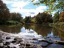
The Whitemud River is a small, highly meandering river in southwest Manitoba. It begins at the junction of Stony Creek and Boggy Creek in Neepawa, and flows east to Arden, Gladstone, Westbourne, discharging into Lake Manitoba at Lynchs Point. Its total drainage area is about 6,500 square kilometres (2,500 sq mi). Other major streams feeding the river include the Big Grass River, Pine Creek, Squirrel Creek, Westbourne Drain and Rat Creek.[1]
The precise origin of the name is not known. The fur trader Alexander Henry referred to it as Rivier Terre Blanche, meaning "White Earth River". Geographic Board of Canada correspondence from a Mr. Garrioch of Portage la Prairie in 1905 indicates that the river got its name from the colour of the clay and soil along its banks.[2]
The river's depth ranges from a few centimeters in the summer to several meters in flood events. Fish species known to inhabit the river include northern pike, white suckers, flathead minnows, emerald shiners, and walleye.
Flows vary dramatically from year to year. The peak flow, measured at Westbourne in April 1979, was 310 cubic metres per second (11,100 cu ft/s), and zero flow has been measured on several occasions. Annual runoff volume has varied from 36,000,000 cubic metres (29,000 acre⋅ft) in 1989 to 611,000,000 cubic metres (495,000 acre⋅ft) in 2001. The mean annual volume at Westbourne is 199,000,000 cubic metres (161,000 acre⋅ft).[3]
See also
References
- Agriculture and Agri-Food Canada - PFRA 2004. Summary of Resources and Land Use Issues Related to Riparian Areas in the Whitemud River Watershed.
- Geographical Names of Manitoba : Manitoba Conservation 2000
- Archived data from Water Survey Canada
| Authority control |
|
|---|