Wisconsin Highway 67
State Trunk Highway 67 (often called Highway 67, STH-67 or WIS 67) is a Wisconsin state highway running from the Wisconsin–Illinois state line east of Beloit north to U.S. Highway 151 (US 151) east of Chilton. With the inclusion of the new Oconomowoc bypass, WIS 67 is approximately 160 miles (260 km) in length.
| ||||
|---|---|---|---|---|
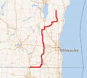
WIS 67 highlighted in red | ||||
| Route information | ||||
| Maintained by WisDOT | ||||
| Length | 160.11 mi[1] (257.67 km) | |||
| Existed | 1916[2]–present | |||
| Major junctions | ||||
| South end | ||||
| North end | ||||
| Location | ||||
| Counties | Rock, Walworth, Waukesha, Dodge, Fond du Lac, Sheboygan, Manitowoc | |||
| Highway system | ||||
| ||||

WIS 67 meanders through much of Southeastern Wisconsin, passing through both the northern and southern units of the Kettle Moraine State Forest. It ends just south of the Killsnake State Wildlife Area in Manitowoc County.
Route description
The southern end of WIS 67 is located on the far east side of Beloit at the Wisconsin–Illinois state line just east of Interstate 90/Interstate 39 (I-90/I-39) where it becomes Illinois Route 75 (IL 75). IL 75 continues westward to South Beloit and Freeport, Illinois.
The northern terminus of the route is at U.S. Highway 151 outside of Chilton, west-southwest of Valders
WIS 67 passes by Old World Wisconsin in Eagle, a "living" outdoor museum run by the State Historical Society of Wisconsin. It also passes Road America in Elkhart Lake; Road America has been the host of many international racing events, from motorcycle to sports car to IndyCar races on its four-mile-long (6.4 km) road course.
History
Initially, WIS 67 traveled from WIS 23 in Plymouth to WIS 48 (now WIS 32/WIS 57) in New Holstein via parts of its present-day routing and present-day CTH-J.[3] In 1920, WIS 67 was superseded by WIS 57's northern extension. As a result, it moved onto another part of its present-day route. The new route traveled from WIS 59/WIS 99 (now just WIS 59) in Eagle to WIS 26 (now WIS 28) in Mayville.[4] In 1924, WIS 67 was extended from both ends. At its northern end, WIS 67 extended northeast to WIS 23 in Plymouth, its former route's southern terminus. At its southern end, WIS 67 extended south via the former southernmost portion of WIS 59. This is because WIS 59 diverged westward from Eagle and extended towards Monroe.[5][6]
In 1947, WIS 67 extended south via US 12 and former CTH-H to WIS 36 (part of it is now Geneva Street) in Williams Bay.[7][8] In 1956, part of WIS 57 moved eastward away from Plymouth. As a result, WIS 67 extended northward to WIS 32/WIS 57 in Kiel via WIS 57's former portion. This extension restored the southern half of WIS 67's oldest alignment.[9][10] Around 1968, WIS 67 extended southwest to US 14 in Walworth, superseding part of WIS 36 in the process.[11][12] Around 1979, WIS 67 extended southward via US 14 and then westward along CTH-W to WIS 140 north of the Illinois state line.[13][14]
Major intersections
| County | Location | mi | km | Destinations | Notes |
|---|---|---|---|---|---|
| Rock | Town of Turtle | 0.00 | 0.00 | Continuation into Illinois | |
| Town of Clinton | |||||
| Walworth | Town of Walworth | Southern end of US 14 overlap | |||
| Walworth | Northern end of US 14 overlap | ||||
| Town of Delavan | |||||
| Elkhorn | I-39 exit 25 | ||||
| Southern end of WIS 11 overlap | |||||
| Northern end of WIS 11 overlap | |||||
| Southern end of US 12 overlap | |||||
| Town of La Grange | Northern end of US 12 overlap | ||||
| Waukesha | Eagle | Southern end of Kettle Moraine Scenic Drive overlap | |||
| Town of Ottawa | Northern end of Kettle Moraine Scenic Drive overlap | ||||
| Dousman–Summit line | |||||
| Summit–Oconomowoc line | I-94 exit 282 | ||||
| Oconomowoc | Southern end of WIS 16 overlap | ||||
| Town of Oconomowoc | Northern end of WIS 16 overlap | ||||
| Dodge | Town of Rubicon | ||||
| Hubbard–Herman town line | |||||
| Mayville | Southern end of WIS 28 overlap | ||||
| Theresa | Southern end of WIS 175 overlap | ||||
| Town of Theresa | Northern end of WIS 28 overlap | ||||
| Lomira | Northern end of WIS 175 overlap | ||||
| Fond du Lac | Town of Auburn | ||||
| Town of Osceola | Western end of Kettle Moraine Scenic Drive overlap | ||||
| Eastern end of Kettle Moraine Scenic Drive overlap | |||||
| Sheboygan | Town of Greenbush | Western end of Kettle Moraine Scenic Drive overlap | |||
| Eastern end of Kettle Moraine Scenic Drive overlap | |||||
| Plymouth | Interchange | ||||
| Manitowoc | Kiel | Roundabout | |||
| Town of Eaton | |||||
1.000 mi = 1.609 km; 1.000 km = 0.621 mi
| |||||
See also
 U.S. Roads portal
References
- Bessert, Chris. "Highways 60–69". Wisconsin Highways. Retrieved March 20, 2007.
- Barquist, Barbara; Barquist, David (1987). "The New Century". In Haley, Leroy (ed.). The Summit of Oconomowoc: 150 Years of Summit Town. Summit History Group. p. 81.
- Wisconsin Highway Commission (1918). Official Map of the State Trunk Highway System of Wisconsin (Map). [c. 1:1,010,000]. Madison: Wisconsin Highway Commission. OCLC 38871736, 69119995. Retrieved January 23, 2021 – via American Geographical Society Library Digital Map Collection.
- Wisconsin Highway Commission (1920). Official Map of the State Trunk Highway System of Wisconsin (Map). Scale not given. Madison: Wisconsin Highway Commission. OCLC 5673515.
- Wisconsin Highway Commission (1923). Official Map of the State Trunk Highway System of Wisconsin (Map). Scale not given. Madison: Wisconsin Highway Commission.
- Wisconsin Highway Commission (1924). Official Highway Map of Wisconsin: 'The Playground of the Middle West' (Map). c. 1:950,400. Madison: Wisconsin Highway Commission. OCLC 560719947. Retrieved January 23, 2021 – via American Geographical Society Library Digital Map Collection.
- State Highway Commission of Wisconsin (January 1947). Official Highway Map of Wisconsin (Map). 1:887,040. Madison: State Highway Commission of Wisconsin. Retrieved January 23, 2021 – via American Geographical Society Library Digital Map Collection.
- State Highway Commission of Wisconsin (January 1948). Official Highway Map of Wisconsin (Map). 1:887,040. Madison: State Highway Commission of Wisconsin. OCLC 232303069. Retrieved January 23, 2021 – via American Geographical Society Library Digital Map Collection.
- State Highway Commission of Wisconsin (1956). Official Highway Map of Wisconsin (Map). 1:887,040. Madison: State Highway Commission of Wisconsin. OCLC 233933988. Retrieved January 23, 2021 – via American Geographical Society Library Digital Map Collection.
- State Highway Commission of Wisconsin (1957). Wisconsin Highway Map (Map). 1:887,040. Madison: State Highway Commission of Wisconsin. Retrieved January 23, 2021 – via American Geographical Society Library Digital Map Collection.
- State Highway Commission of Wisconsin (1967). Wisconsin Highway Map (Map). 1:823,680. Madison: State Highway Commission of Wisconsin. Retrieved January 23, 2021 – via American Geographical Society Library Digital Map Collection.
- State Highway Commission of Wisconsin (1969). Wisconsin Highway Map (Map). Scale not given. Madison: State Highway Commission of Wisconsin. Retrieved January 23, 2021 – via American Geographical Society Library Digital Map Collection.
- Wisconsin Department of Transportation Division of Highways (1978). Wisconsin Highway Map (Map) (1978–1979 ed.). 1:823,680. Madison: Wisconsin Department of Transportation. OCLC 174123957. Retrieved January 23, 2021 – via American Geographical Society Library Digital Map Collection.
- Wisconsin Department of Transportation Division of Highways (1980). Wisconsin Highway Map (Map) (1980–1981 ed.). 1:823,680. Madison: Wisconsin Department of Transportation. OCLC 613423704, 77526920. Retrieved January 23, 2021 – via American Geographical Society Library Digital Map Collection.
External links
| Wikimedia Commons has media related to Wisconsin Highway 67. |
- Oconomowoc Bypass Project page from Wisconsin Department of Transportation
- Old World Wisconsin from Wisconsin Historical Society