Wollaston Lake
Wollaston Lake is a lake in northeastern Saskatchewan, Canada. It is 550 kilometres (340 mi) northeast of Prince Albert. With a surface area of 2,286 square kilometres (883 sq mi) (excluding islands; 2,681 square kilometres (1,035 sq mi) if islands are included),[6] it is the largest bifurcation lake in the world – that is, a lake that drains naturally in two directions.[7]
| Wollaston Lake | |
|---|---|
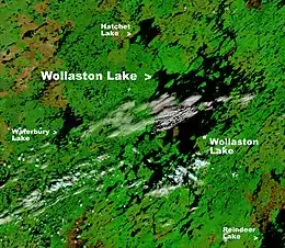 NASA image of Wollaston Lake | |
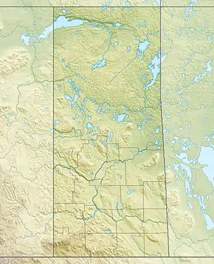 Wollaston Lake Location of Wollaston Lake in Saskatchewan | |
| Location | northeastern Saskatchewan |
| Coordinates | 58°15′N 103°20′W |
| Type | Glacial lake |
| Primary inflows | Geikie River |
| Primary outflows | Fond du Lac River,(10%) Cochrane River(90%)[1] |
| Catchment area | 20,000 km2 (7,700 sq mi) |
| Basin countries | Canada |
| Surface area | 2,681 km2 (1,035 sq mi) |
| Average depth | 20.6 m (68 ft) |
| Max. depth | 97 m (318 ft) |
| Water volume | 39.8 km3 (32,300,000 acre⋅ft) |
| Shore length1 | 1,475 km (917 mi) |
| Surface elevation | 398 m (1,306 ft) |
| Settlements | Wollaston Lake, Saskatchewan |
| References | [2][3][4][5][6] |
| 1 Shore length is not a well-defined measure. | |
About 10% of the lake's water drains into the Fond du Lac River, which flows out of the lake to the northwest, where it drains into Lake Athabasca, which ultimately drains into the Arctic Ocean via the Mackenzie River system. The rest of the water drains into the Cochrane River, which flows out of the northeastern side of the lake and into Reindeer Lake, which drains via the Churchill River system into Hudson Bay.[1]
Wollaston Lake's main inflow is the Geikie River which flows from the southwest into the southwest section of the lake. If Hudson Bay is considered an arm of the Atlantic Ocean, then the Geikie is the largest river in the world to flow naturally into two oceans.
Wollaston Lake is also the largest lake entirely within Saskatchewan, although the Saskatchewanian portions of Lake Athabasca and Reindeer Lake are both larger.
Samuel Hearne learned of the lake in 1770 and David Thompson noted in 1796 the dual outlets as "perhaps without parallel in the world."[8] In 1807, Peter Fidler named the lake after William Hyde Wollaston.
The only settlement on its shores is also named Wollaston Lake. The settlement includes the northern hamlet of Wollaston Lake with a population of 129[9] and the adjacent village of Wollaston Post of the Hatchet Lake Dene Nation with a population of 1251.[10][11][12]
Access
Access to the lake is provided by the community airstrip (Wollaston Lake Airport) and an all-weather road (Highway 905) to La Ronge.[12] This road passes by the western side of the lake, while the community of Wollaston Lake is located on the eastern side, but the lake can be crossed by a winter road when the lake is frozen (November through June)[5] and by the Wollaston barge when it is not.[12] Air service is also provided to Points North Landing, a service centre for nearby uranium mines. This industry provides jobs for local residents, but has raised concerns over possible contamination of the lake.
Fish species
Fish species found in the lake include walleye, yellow perch, northern pike, lake trout, Arctic grayling, lake whitefish, cisco, burbot, white sucker and longnose sucker.
Treated effluent from the Rabbit Lake uranium mine is released into Hidden Bay on the southwestern side of the lake.[13]
References
- https://books.google.com/books?id=uPgDwqflBNsC&pg=PA66&lpg=PA66&dq=Wollaston+Lake+Cochrane+River&source=bl&ots=DNdhTtgINZ&sig=fXrDak1Ub4CBlwgEV1aAk7BRC3A&hl=en&sa=X&ved=0ahUKEwirn9D4vM3KAhWPsh4KHd6OA5YQ6AEIKDAC#v=onepage&q=Wollaston%20Lake%20Cochrane%20River&f=false
- "Principal lakes, elevation and area, by province and territory". Statistics Canada. 2005-02-02. Retrieved 2015-03-11.
- "World Lake Database (Wollaston Lake)". Retrieved 2015-02-21.
- LakeNet
- Data Summary Archived March 13, 2007, at the Wayback Machine
- Natural Resources Canada
- The Atlas of Canada - Parks and Environment
- The Encyclopedia of Saskatchewan | Details
- "Ministry of Municipal Affairs-Northern Settlement of WOLLASTON LAKE". Retrieved 2012-10-28.
- "Statistics Canada. 2012. Lac La Hache 220, Saskatchewan". Retrieved 2012-10-28.
- Saskatchewan wildfire forces emergency airlift - Saskatchewan - CBC News
- Wollaston Lake Archived October 11, 2006, at the Wayback Machine
- Wollaston Lake