Yucatán Peninsula
The Yucatán Peninsula (/ˌjuːkəˈtɑːn/,[1] also UK: /ˌjʊk-/,[2] US: /-ˈtæn, ˌjuːkɑːˈtɑːn/;[1][3][4] Spanish: Península de Yucatán), in southeastern Mexico, separates the Caribbean Sea from the Gulf of Mexico, with the northern coastline on the Yucatán Channel. The peninsula lies east of the Isthmus of Tehuantepec, a northeastern geographic partition separating the region of Central America from the rest of North America. It is approximately 181,000 km2 (70,000 sq mi) in area, and is almost entirely composed of limestone.[5][6]
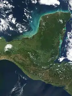 Satellite image of the Yucatán Peninsula | |
 | |
| Geography | |
|---|---|
| Location | North America |
| Coordinates | 19°22′00″N 89°12′00″W |
| Adjacent bodies of water |
|
Etymology
The proper derivation of the word Yucatán is widely debated. 17th century Franciscan historian Diego López de Cogolludo offers two theories in particular.[7] In the first one, Francisco Hernández de Córdoba, having first arrived to the peninsula in 1517, inquired the name of a certain settlement and the response in Yucatec Mayan was "I don't understand", which sounded like yucatán to the Spaniards.[7][8] There are many possibilities of what the natives could have actually said, among which "mathan cauyi athán", "tectecán", "ma'anaatik ka t'ann" and "ci u t'ann".[7][8][9] This origin story was first told by Hernán Cortés in his letters to Charles V.[10][11][12] Later 16th century historians Motolinia and Francisco López de Gómara also repeat this version.[12] In some versions the expedition is not the one captained by Córdoba but instead the one a year later captained by Juan de Grijalva.[13] The second major theory is that the name is in some way related to the yuca crop, as written by Bernal Díaz del Castillo.[7][12] Others theories claim that it is a derivative of Chontal Tabascan word yokat'an meaning speaker of the Yoko ochoco language, or an incorrect Nahuatl term yokatlan as supposedly "place of richness" (yohcāuh can't be paired with tlán).[12]
History
Pre-human
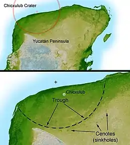
The Yucatán Peninsula is the site of the Chicxulub crater impact, which was created 66 million years ago by an asteroid of about 10 to 15 kilometers (6 to 9 miles) in diameter at the end of the Cretaceous Period.[14]
Maya
The Yucatán Peninsula constitutes a significant proportion of the ancient Maya lowlands and was the central location of the Mayan Civilization. The Mayan culture also extended south of the Yucatán Peninsula into Guatemala, Honduras and into the highlands of Chiapas.[6] There are many Maya archaeological sites throughout the peninsula; some of the better-known are Chichen Itza, Coba, Tulum and Uxmal.[15] Indigenous Maya and Mestizos of partial Maya descent make up a sizable portion of the region's population, and Mayan languages are widely spoken there.
Spanish conquest
Archaeological findings
In 2020, an underwater archaeological expedition led by Jerónimo Avilés excavated Chan Hol cave, near the Tulum archaeological site in the state of Quintana Roo on the peninsula, and revealed the skeleton of a woman approximately 30 years of age who lived at least 9,900 years ago. According to craniometric measurements, the skull is believed to conform to the mesocephalic pattern, like the other three skulls found in Tulum caves. Three different scars on the skull of the woman showed that she was hit with something hard and her skull bones were broken. Her skull also had crater-like deformations and tissue deformities that appeared to be caused by a bacterial relative of syphilis.[16]
According to study lead researcher Wolfgang Stinnesbeck, "It really looks as if this woman had a very hard time and an extremely unhappy end of her life. Obviously, this is speculative, but given the traumas and the pathological deformations on her skull, it appears a likely scenario that she may have been expelled from her group and was killed in the cave, or was left in the cave to die there”.[17]
The newly discovered skeleton was 140 meters away from the Chan Hol 2 site. Although archaeologists assumed the divers found the remains of the missing Chan Hol 2, the analysis proved that these assumptions were erroneous in a short time. Stinnesbeck compared the new bones to old photographs of Chan Hol 2 and showed that the two skeletons represent different individuals.[18]
Due to their distinctive features, study co-researcher Samuel Rennie suggest the existence of at least two morphologically diverse groups of people living separately in Mexico during the transition from Pleistocene to Holocene.[19]
Current administration
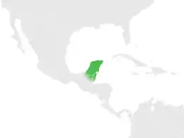
The peninsula comprises the Mexican states of Yucatán, Campeche, and Quintana Roo, as well as Guatemala's Petén Department and almost the whole of Belize.[20]
Population
Population throughout the Yucatan Peninsula is very different throughout each part of the Peninsula. Population density and ethnic composition are two factors that play into the total population. The most populated area is Mérida in Yucatan state as well as the areas that surround that region. The least populated part of the peninsula is Quintana Roo which is a state located in the Southeastern part of Mexico. In terms of ethnic composition, a majority of the population consisted of both Maya and Mestizos.[21]
Economy
In the late historic and early modern eras, the Yucatán Peninsula was largely a cattle ranching, logging, chicle and henequen production area. Since the 1970s, the Yucatán Peninsula has reoriented its economy towards tourism, especially in the Mexican state of Quintana Roo. Aside from tourism, another source of income that is important in the Peninsula is logging as well as chicle industries specifically in Belize. Oil was also found in certain parts of the Yucatán, bringing in more economic opportunities.[22] Once a small fishing village, Cancún in the northeast of the peninsula has grown into a thriving city. The Riviera Maya, which stretches along the east coast of the peninsula between Cancún and Tulum, houses over 50,000 beds. The best-known locations are the former fishing town of Playa del Carmen, the ecological parks Xcaret and Xel-Há and the Maya ruins of Tulum and Coba.
Geology
The peninsula is the exposed portion of the larger Yucatán Platform, all of which is composed of carbonate and soluble rocks, being mostly limestone although dolomite and evaporites are also present at various depths. The whole of the Yucatán Peninsula is an unconfined flat lying karst landscape.[6] Sinkholes, known locally as cenotes, are widespread in the northern lowlands.
According to the Alvarez hypothesis, the mass extinction of the dinosaurs at the transition from the Cretaceous to the Paleogene Period, the Cretaceous–Paleogene boundary (K–Pg boundary), 65 million years ago was caused by an asteroid impact somewhere in the greater Caribbean Basin.[23] The deeply buried Chicxulub crater is centered off the north coast of the peninsula near the town of Chicxulub. The now-famous "Ring of Cenotes," a geologic structure composed of sinkholes arranged in a semi-circle, outlines one of the shock-waves from this impact event in the ~66 million year old rock. The existence of the crater has been supported by evidence including the aforementioned "Ring of Cenotes", as well as the presence of impact debris such as shocked quartz and tektites, a type of glass formed during meteorite impacts.[24]
The Arrowsmith Bank is a submerged bank located off the northeastern end of the peninsula.[25]
Water resources
Due to the extreme karst nature of the whole peninsula, the northern half is devoid of rivers. Where lakes and swamps are present, the water is marshy and generally unpotable. Due to its coastal location, the whole of the peninsula is underlain by an extensive contiguous density stratified coastal aquifer, where a fresh water lens formed from meteoric water floats on top of intruding saline water from the coastal margins. The thousands of sinkholes known as cenotes throughout the region provide access to the groundwater system. The cenotes have long been relied on by ancient and contemporary Maya people.[6][26]
Flora
Short and tall tropical jungles are the predominant natural vegetation types of the Yucatán Peninsula. The boundaries between northern Guatemala (El Petén), Mexico (Campeche and Quintana Roo), and western Belize are still occupied by the largest continuous tracts of tropical rainforest in Central America. However, these forests are suffering extensive deforestation.
Climate
Like much of the Caribbean, the peninsula lies within the Atlantic Hurricane Belt, and with its almost uniformly flat terrain it is vulnerable to these large storms coming from the east, and the area has been devastated by many hurricanes, such as Hurricane Gilbert, Hurricane Emily, Hurricane Wilma, and Hurricane Dean.
Strong storms called nortes can quickly descend on the Yucatán Peninsula any time of year. Although these storms pummel the area with heavy rains and high winds, they tend to be short-lived, clearing after about an hour. The average percentage of days with rain per month ranges from a monthly low of 7% in April to a high of 25% in October. Breezes can have a cooling effect, humidity is generally high, particularly in the remaining rainforest areas.[27]
References
- "Yucatán". Collins English Dictionary. HarperCollins. Retrieved 26 July 2019.
- "Yucatán". Lexico UK Dictionary. Oxford University Press. Retrieved 26 July 2019.
- "Yucatán". The American Heritage Dictionary of the English Language (5th ed.). Boston: Houghton Mifflin Harcourt. Retrieved 26 July 2019.
- "Yucatán". Merriam-Webster Dictionary. Retrieved 26 July 2019.
- McColl, R. W. (2005). Encyclopedia of World Geography. New York: Facts On File. pp. 1002–1003. ISBN 0816057869.
- Scheffel, Richard L.; Wernet, Susan J., eds. (1980). Natural Wonders of the World. United States of America: Reader's Digest Association, Inc. p. 420. ISBN 0-89577-087-3.
- Mayr, Renate Johanna (2014). Belize : tracking the path of its history : from the heart of the Maya Empire to a retreat for buccaneers, a safe-haven for ex-pirates and pioneers, a crown colony and a modern nation. LIT Verlag Münster. p. 36. ISBN 9783643904812. Retrieved February 9, 2020.
- Kane, Njord (2016). The Maya: The Story of a People. Spangenhelm Publishing. ISBN 9781943066049. Retrieved February 9, 2020.
- González, John Morán; Lomas, Laura (2018). The Cambridge History of Latina/o American Literature. Cambridge University Press. p. 36. ISBN 9781316873670. Retrieved February 9, 2020.
- Cartas y relaciones de Hernan Cortés al emperador Carlos V (in Spanish). Paris: A. Chaix y ca. 1866. p. 1 footnote 2. Retrieved 2010-12-13.
- "Ibero-American Electronic Text Series: Primera Carta de Relación, PREÁMBULO" (in Spanish). Board of Regents of the University of Wisconsin System. 1945. Retrieved 2010-12-13.
- Hajovsky, Ric (2011). "How Yucatan got its name". Everything Cozumel. Retrieved February 3, 2020.
- Beding, Silvio A. (2016). The Christopher Columbus encyclopedia. Springer. p. 304. ISBN 9781349125739. Retrieved February 9, 2020.
- Renne, P. R.; Deino, A. L.; Hilgen, F. J.; Kuiper, K. F.; Mark, D. F.; Mitchell, W. S.; Morgan, L. E.; Mundil, R.; Smit, J. (2013). "Time Scales of Critical Events Around the Cretaceous-Paleogene Boundary". Science. 339 (6120): 684–687. Bibcode:2013Sci...339..684R. doi:10.1126/science.1230492. PMID 23393261.
- "Yucatan map".
- Stinnesbeck, Wolfgang; Rennie, Samuel R.; Olguín, Jerónimo Avilés; Stinnesbeck, Sarah R.; Gonzalez, Silvia; Frank, Norbert; Warken, Sophie; Schorndorf, Nils; Krengel, Thomas; Morlet, Adriana Velázquez; González, Arturo González (2020-02-05). "New evidence for an early settlement of the Yucatán Peninsula, Mexico: The Chan Hol 3 woman and her meaning for the Peopling of the Americas". PLOS ONE. 15 (2): e0227984. doi:10.1371/journal.pone.0227984. ISSN 1932-6203. PMC 7001910. PMID 32023279.
- cowie, ashley. "9,900-Year-Old Skeleton Found in Mexican Cenote Rewrites History". www.ancient-origins.net. Retrieved 2020-03-19.
- PLOS (2020-02-05). "9,900-Year-Old Skeleton Discovered in Submerged Mexican Cave Has a Distinctive Skull". SciTechDaily. Retrieved 2020-03-19.
- February 2020, Laura Geggel-Associate Editor 05. "9,900-year-old skeleton of horribly disfigured woman found in Mexican cave". livescience.com. Retrieved 2020-03-19.
- "Yucatán Peninsula". Encyclopaedia Britannica. Retrieved 7 August 2018.
- "Yucatán Peninsula | peninsula, Central America". Encyclopedia Britannica. Retrieved 2020-12-10.
- "Yucatán Peninsula | peninsula, Central America". Encyclopedia Britannica. Retrieved 2020-12-10.
- Yarris, Lynn (2010-03-09). "Alvarez Theory on Dinosaur Die-Out Upheld: Experts Find Asteroid Guilty of Killing the Dinosaurs". News Center. Retrieved 2020-12-08.
- "Chicxulub Crater and Ring of Cenotes". Karst Geochemistry and Hydrogeology. 2018-04-04. Retrieved 2020-12-08.
- Arrowsmith Bank, Undersea Features - Geographical Names
- BBC: Planet Earth, part 4: Caves.
- Juan Luis Pena Chapa, Manuel Martin Castillo, and Juan Carlos Gonzalez Avila, The Performance of the Economy of the Yucatan Peninsula from 1970–1993
- Marcio L. Teixeira,The Impact of the Geologic History of the Yucatán Peninsula on the Present Day Aquifer,2004
- Angelo Heilprin,Observations on the Flora of Northern Yucatan
External links
 Media related to Yucatán Peninsula at Wikimedia Commons
 Yucatán Peninsula travel guide from Wikivoyage
Places adjacent to Yucatán Peninsula | |
|---|---|
| Authority control |
|
|---|