Zeya (river)
The Zeya (Russian: Зе́я; from indigenous Evenki word "djee" (blade); Chinese: 结雅; Manchu: ᠵᡳᠩᡴᡳᡵᡳ
ᠪᡳᡵᠠ, Mölendroff: jingkiri bira) is a northern, left tributary of the Amur in Amur Oblast, Russia. It is 1,242 kilometres (772 mi) long, and has a drainage basin of 233,000 square kilometres (90,000 sq mi).[2]
| Zeya | |
|---|---|
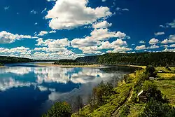 Island on the Zeya. | |
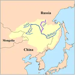 Map of the Amur drainage basin with the Zeya highlighted | |
| Native name | Зея |
| Location | |
| Country | Russia |
| Federal subject | Amur Oblast |
| Physical characteristics | |
| Source | Tokiysky Stanovik |
| Mouth | Amur |
• coordinates | 50.2419°N 127.598°E |
| Length | 1,242 km (772 mi) |
| Basin size | 233,000 km2 (90,000 sq mi) |
| Discharge | |
| • location | Blagoveshchensk [1] |
| • average | 1,800 m3/s (64,000 cu ft/s) |
| • minimum | 1.5 m3/s (53 cu ft/s) |
| • maximum | 14,200 m3/s (500,000 cu ft/s) |
| Basin features | |
| Progression | Amur→ Sea of Okhotsk |
History
The first Russian to enter the area was Vassili Poyarkov.
Course
It rises in the Tokiysky Stanovik mountain ridge, a part of the Stanovoy Range.
The Zeya flows through the Zeya Reservoir, at the junction of the Tukuringra Range and Dzhagdy Range, and joins the Amur near Blagoveshchensk, at the border with China. Regulation of river discharge by Zeya Dam mitigates extremities of river flow down to 5000 m³/s.
The main tributaries of the Zeya are Tok, Mulmuga, Bryanta, Gilyuy, and Urkan on the right, and Kupuri, Argi, Dep, Selemdzha, and Tom on the left.[3]
The river freezes from November to May. It is navigable with the most important river ports being Zeya, Svobodny, and Blagoveshchensk.
References
- Sokolov, Far East // Hydrography of USSR. (in Russian)
- Река ЗЕЯ in the State Water Register of Russia (Russian)
- Зея (река в Амурской обл.), Great Soviet Encyclopedia