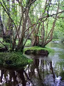
Pillhill Brook
Pilhill Brook is a 9.9-kilometre-long (6.2 mi) tributary of the River Anton in Hampshire, England.[1] It is a chalk stream, known for its trout fishing.


Toponomy
The brook is believed to have been called the Ann, or Anna.[2] The name aqua de Anne is found in the Close Rolls in 1228.[3]
Course
The brook rises near Fyfield and passes Thruxton before flowing through Anna Valley past the villages of Abbotts Ann, Little Ann and Amport, joining the River Anton near Upper Clatford,[2] which flows in turn into the River Test.[1]
Industry
in 1813, the brothers, Robert and William Tasker, set up the Waterloo Ironworks in the Anna Valley at Upper Clatford, using a waterwheel driven by the brook to power the forge. They specialised in making agricultural equipment, progressing to the manufacture of steam traction engines from 1865. There were four conventional watermills on the brook, Upper Mill at Monxton,[4] Upper Mill at Abbots Ann,[5] Abbots Ann Mill[6] and Sarsons Mill at Amport.[7]
Water quality
The Environment Agency measures water quality of the river systems in England. Each is given an overall ecological status, which may be one of five levels: high, good, moderate, poor and bad. There are several components that are used to determine this, including biological status, which looks at the quantity and varieties of invertebrates, angiosperms and fish, and chemical status, which compares the concentrations of various chemicals against known safe concentrations. Chemical status is rated good or fail.[8]
Water quality of the Pillhill Brook in 2019:
| Section | Ecological Status | Chemical Status | Overall Status | Length | Catchment | Channel |
|---|---|---|---|---|---|---|
| Pillhill Brook[9] | Good | Fail | Moderate | 9.879 km (6.139 mi) | 69.913 km2 (26.994 sq mi) |
See also
| Main rivers main tributaries & sub-tributaries |
|  | ||||||||||
|---|---|---|---|---|---|---|---|---|---|---|---|---|
| Canals and Navigations | ||||||||||||
| Ordinary watercourses | ||||||||||||
| Lakes, ponds and wetlands | ||||||||||||
| Coast | ||||||||||||
Categories: Rivers, Canals | ||||||||||||
References
- "Pillhill Brook". Catchment Data Explorer. Environment Agency. Retrieved 24 January 2017.
- Eilert Ekwall (1928). English River Names. OUP. p. 15.
- Close Roll, 1228 - reproduced as Close Rolls. Public Record Office. 1902–1938.
- "Upper Mill, Monxton". Mills Archive. Retrieved 6 September 2020.
- "Upper Mill, Abbots Ann". Mills Archive. Retrieved 6 September 2020.
- "Watermill, Abbots Ann". Mills Archive. Retrieved 6 September 2020.
- "Sarson's Mill, Amport". Mills Archive. Retrieved 6 September 2020.
- "Glossary (see Biological quality element; Chemical status; and Ecological status)". Catchment Data Explorer. Environment Agency. 17 February 2016.
- "Pillhill Brook". Catchment Data Explorer. Environment Agency.