Ötztaler Ache
The Ötztaler Ache is a river in the district of Imst, Tyrol, Austria, a right tributary of the Inn.
| Ötztaler Ache | |
|---|---|
 The Ötztaler Ache near Sautens | |
 | |
| Location | |
| Country | Austria |
| State | Tyrol |
| Physical characteristics | |
| Source | |
| • location | Ötztal Alps |
| Mouth | |
• location | Inn |
• coordinates | 47.2322°N 10.8383°E |
| Length | 66.5 km (41.3 mi) [1] |
| Basin size | 893 km2 (345 sq mi) [1] |
| Basin features | |
| Progression | Inn→ Danube→ Black Sea |
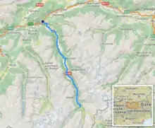
The Ötztaler Ache flows through the Ötztal valley, a southern branch the Inntal. Including its source rivers Venter Ache and Rofenache, it is 66.5 kilometres (41.3 mi) long. The Rofenache is the runoff of the Hintereisferner, a glacier at the foot of the Weißkugel, Ötztal Alps. At Vent, near Sölden, it takes up the Niedertalbach and its name changes to Venter Ache. At the confluence with the Gurgler Ache in Zwieselstein, Sölden, the Ötztaler Ache proper is formed. It flows through Sölden, Längenfeld, Umhausen and Oetz before joining the Inn 8 kilometres (5.0 mi) east of Imst. The river is one of its bigger tributaries.
References
This article is issued from Wikipedia. The text is licensed under Creative Commons - Attribution - Sharealike. Additional terms may apply for the media files.
