Česká Ves
Česká Ves (German: Böhmischdorf, both meaning "Bohemian Village") is a municipality and village in Jeseník District in the Olomouc Region of the Czech Republic. It has about 2,400 inhabitants.
Česká Ves | |
|---|---|
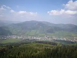 Panorama of Česká Ves | |
 Flag  Coat of arms | |
 Česká Ves Location in the Czech Republic | |
| Coordinates: 50°15′27″N 17°13′41″E | |
| Country | |
| Region | Olomouc |
| District | Jeseník |
| First mentioned | 1416 |
| Area | |
| • Total | 24.51 km2 (9.46 sq mi) |
| Elevation | 399 m (1,309 ft) |
| Population (2020-01-01[1]) | |
| • Total | 2,393 |
| • Density | 98/km2 (250/sq mi) |
| Time zone | UTC+1 (CET) |
| • Summer (DST) | UTC+2 (CEST) |
| Postal code | 790 81 |
| Website | www |
Česká Ves lies approximately 3 kilometres (2 mi) north of Jeseník, 74 km (46 mi) north of Olomouc, and 200 km (124 mi) east of Prague. It is about 13 km (8 mi) from the border with Poland.
Geography
Česká Ves lies in a small valley, surrounded by forest and hills, the highest of which is Praděd (1,492 m). The river Bělá flows through Česká Ves. During the nationwide floods in 1997, the river rose up to 6 meters and half of the village was destroyed, including part of the main street.
History
According to the Austrian census of 1910 the village had 2,434 inhabitants, 2,419 of whom had permanent residence there. According to the census, all 2,419 permant residents spoke German as their native language. The most populous religious group were Roman Catholics with 2,417 (99.3%).[2]
References
- "Population of Municipalities – 1 January 2020". Czech Statistical Office. 2020-04-30.
- Ludwig Patryn (ed): Die Ergebnisse der Volkszählung vom 31. Dezember 1910 in Schlesien, Troppau 1912.
| Wikimedia Commons has media related to Česká Ves. |
