Ōpunake
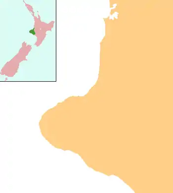
Ōpunake is a small town on the southwest coast of Taranaki in New Zealand's North Island. It is located 45 kilometres southwest of New Plymouth. Rahotu is 16 km to the northwest. Manaia is 29 km to the southeast. State Highway 45 passes through the town.[2][3] The town has a population of 1,440 (June 2020).[1]
Ōpunake | |
|---|---|
 Ōpunake  Ōpunake | |
| Coordinates: 39°27′S 173°51′E | |
| Country | New Zealand |
| Region | Taranaki |
| Territorial authority | South Taranaki District |
| Area | |
| • Urban | 3.73 km2 (1.44 sq mi) |
| Population (June 2020)[1] | |
| • Urban | 1,440 |
| • Urban density | 390/km2 (1,000/sq mi) |
| Postcode | 4616 |


History and culture
Pre-European history
In 1833 local chief Wiremu Kīngi Moki Matakātea held off a war party from Waikato for several weeks with a single musket, and eventually triumphed. In 1865 the Opunake redoubt was established by the 70th Regiment, but little trace of it remains.
The site of Te Namu Pā is along the coast, just north of the town.[4]
European settlement
The town was first settled by Europeans in the 1860s, when British army soldiers landed at Ōpunake in April 1865 in the Second Taranaki War.[5] By May, soldiers had constructed the Ōpunake Redoubt, where 350 soldiers were stationed.[5] In May 1867, the redoubt was gifted to Wiremu Kīngi Moki Te Matakātea's people, and the area became a location for flax mills, outside European influence.[5] British soldiers re-established a presence at the redoubt in 1875, and the area became a rallying point for soldiers during the invasion of Parihaka.[5] By circa 1887, the redoubt was abandoned.[5] Ōpunake was intended to be a major port but, other than a jetty constructed in 1891, little else was completed.[6]
Marae
Ōpunake has two marae. Ōeo Marae and Tipua Horonuku and Tipua Hororangi meeting houses are affiliated with the Ngāruahine hapū of Ngāti Tamaahuroa me Tītahi. Ōrimupiko Marae and Ōhinetuhirau meeting house are a meeting place for the Taranaki hapū of Ngāti Haumia, Ngāti Tamarongo and Ngāti Kahumate.[7][8]
In October 2020, the Government committed $153,419 from the Provincial Growth Fund to seal the driveway of the marae and paint the outside of all buildings, creating 12 jobs.[9]
Demographics
The Ōpunake urban area had a usual resident population of 1,401 at the 2018 New Zealand census, an increase of 66 people (4.9%) since the 2013 census, and an increase of 36 people (2.6%) since the 2006 census. There were 681 males and 720 females, giving a sex ratio of 0.95 males per female. The median age was 44.2 years; 282 people (20.1%) were aged under 15 years, 216 (15.4%) were 15 to 29, 597 (42.6%) were 30 to 64, and 303 (21.6%) were 65 or older.[10]
Ethnicities were 76.0% European/Pākehā, 37.7% Māori, 2.4% Pacific peoples, 3.4% Asian, and 1.9% other ethnicities (totals add to more than 100% since people could identify with multiple ethnicities).[10]
Features
Ōpunake is the centre for the local dairy industry, and is also a popular tourist spot. The beach is composed of volcanic blacksand and there are large rock pools to be found on the north-west end of the beach at low tide.
The Ōpunake and surrounding community has a South Taranaki District Council LibraryPlus, which provides full library and Council related services.
The Ōpunake murals, located on the main road in the town, reflect the town's farming history, Māori culture and modern history.[11]


Education
Opunake High School is a coeducational secondary (years 9-13) school with a roll of 313 students as of March 2020.[12] The school celebrated its 75th jubilee in 2000.[13]
Opunake School, St Joseph's School, and Te Kura Kaupapa Maori o Tamarongo are full primary (years 1-8) schools with rolls of 205, 79 and 8 respectively.[12] St Joseph's is a state integrated Catholic school. Te Kura Kaupapa Maori o Tamarongo is a Kura Kaupapa Māori school which teaches in the Māori language.
Notable people
- Jim Bolger (born 1935), former New Zealand Prime Minister
- Carl Hayman (born 1979), rugby union footballer who played prop
- Graham Mourie (born 1952), All Black captain
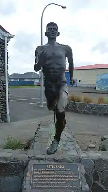
- Peter Snell (1938–2019), middle distance runner, a sculpture was unveiled on Saturday 19 May 2007
See also
Notes
- "Population estimate tables - NZ.Stat". Statistics New Zealand. Retrieved 22 October 2020.
- Peter Dowling (editor) (2004), Reed New Zealand Atlas, Reed Books, map 34, ISBN 0-7900-0952-8CS1 maint: extra text: authors list (link)
- Roger Smith, GeographX (2005), The Geographic Atlas of New Zealand, Robbie Burton, map 96, ISBN 1-877333-20-4
- Tapsell, Paul; Arawa, Te (1 March 2017), "Taonga, marae, whenua - negotiating custodianship", Rethinking settler colonialism, Manchester University Press, ISBN 978-1-5261-2154-7, retrieved 15 September 2020
- Prickett, Nigel (1999). "BRITISH ARMY AND COLONIAL FORTIFICATIONS IN NORTH TARANAKI, 1865-69". Records of the Auckland Institute and Museum. 36: 5–58. ISSN 1174-9202.
- "Opunake Travel Guide". Jasons Travel Media.
- "Te Kāhui Māngai directory". tkm.govt.nz. Te Puni Kōkiri.
- "Māori Maps". maorimaps.com. Te Potiki National Trust.
- "Marae Announcements" (Excel). growregions.govt.nz. Provincial Growth Fund. 9 October 2020.
- "Age and sex by ethnic group (grouped total response), for census usually resident population counts, 2006, 2013, and 2018 Censuses (urban rural areas)". nzdotstat.stats.govt.nz. Retrieved 6 October 2020.
- Assorted Wall Murals called "Reflections of Opunake" 1900 - 2000 Commissioned by the Egmont Arts Council. Designed and Painted by Mural Artist Dennis Lattimer during April/May 2002. Opunake, Taranaki, North Island, New Zealand. Official website
- "New Zealand Schools Directory". New Zealand Ministry of Education. Retrieved 26 April 2020.
- "Jubilees & reunions - Opunake High School", Education Gazette New Zealand, 78 (16), 13 September 1999