Železná Ruda
Železná Ruda (literally "iron ore", Czech pronunciation: [ˈʒɛlɛznaː ˈruda], German: Markt Eisenstein) is a town in the Plzeň Region of the Czech Republic. It has about 1,600 inhabitants. It is located in the Šumava Mountains, close to the border with Bavaria and the German town Bayerisch Eisenstein. It is one of the important sports and tourism centres of the Šumava Mountains.
Železná Ruda | |
|---|---|
Town | |
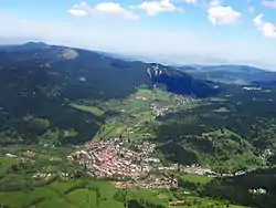 Aerial view | |
 Flag  Coat of arms | |
 Železná Ruda Location in the Czech Republic | |
| Coordinates: 49°8′28″N 13°13′48″E | |
| Country | |
| Region | Plzeň |
| District | Klatovy |
| Founded | 16th century |
| Parts | List
|
| Government | |
| • Mayor | Filip Smola |
| Area | |
| • Total | 79.79 km2 (30.81 sq mi) |
| Elevation | 820 m (2,690 ft) |
| Population (2020-01-01[1]) | |
| • Total | 1,643 |
| • Density | 21/km2 (53/sq mi) |
| Time zone | UTC+1 (CET) |
| • Summer (DST) | UTC+2 (CEST) |
| Postal code | 340 04 |
| Website | www |
History
Železná Ruda was founded at the beginning of the 16th century.[2] The German name of the town comes from The Middle Ages, when it was a market town. Its German population was expelled after 1945.
Geography and climate
Železná Ruda, lying in a wild mountainous terrain at an elevation between 710 and 1,214 metres (2,329 and 3,983 ft), is surrounded with thick coniferous woods. Its climate is cool and wet humid continental hemiboreal (Dfb) with moderately cold, long winters and cool summers. Average July temperature is 15.1 °C (59.2 °F) and average January temperature is −4.2 °C (24.4 °F). Yearly average is 5.7 °C (42.3 °F) and there is some 967 mm of precipitation.
| Climate data for Markt Eisenstein - Železná Ruda | |||||||||||||
|---|---|---|---|---|---|---|---|---|---|---|---|---|---|
| Month | Jan | Feb | Mar | Apr | May | Jun | Jul | Aug | Sep | Oct | Nov | Dec | Year |
| Average high °C (°F) | −1.2 (29.8) |
0.1 (32.2) |
5.2 (41.4) |
10.3 (50.5) |
15.3 (59.5) |
18.6 (65.5) |
20.3 (68.5) |
19.7 (67.5) |
16.3 (61.3) |
10.7 (51.3) |
4.0 (39.2) |
0.2 (32.4) |
10.0 (50.0) |
| Daily mean °C (°F) | −4.2 (24.4) |
−3.4 (25.9) |
0.9 (33.6) |
5.3 (41.5) |
10.0 (50.0) |
13.4 (56.1) |
15.1 (59.2) |
14.6 (58.3) |
11.3 (52.3) |
6.4 (43.5) |
1.2 (34.2) |
−2.4 (27.7) |
5.7 (42.3) |
| Average low °C (°F) | −7.2 (19.0) |
−6.9 (19.6) |
−3.4 (25.9) |
0.3 (32.5) |
4.7 (40.5) |
8.2 (46.8) |
9.9 (49.8) |
9.5 (49.1) |
6.4 (43.5) |
2.2 (36.0) |
−1.6 (29.1) |
−4.9 (23.2) |
1.4 (34.5) |
| Average precipitation mm (inches) | 85 (3.3) |
60 (2.4) |
70 (2.8) |
59 (2.3) |
86 (3.4) |
96 (3.8) |
111 (4.4) |
101 (4.0) |
80 (3.1) |
64 (2.5) |
64 (2.5) |
91 (3.6) |
967 (38.1) |
| Source: Climate-Data.ORG | |||||||||||||
Sights
Natural
The town is surrounded by forests and green mountains. There are many popular tourist sites, such as the lakes Černé jezero and Čertovo jezero and Špičák peak (1,202 m).
Historical
Historical sites include the Church of Panna Maria Pomocná z Hvězdy (with an Eastern-style cupola), the Chapel of St. Barbora (saint of mineworkers) and the Way of the Cross. The local museum and information centre are located in a house, which was the home to a well-known family of glassmakers in the past. There is an exhibition of traditional glass, documents and photographs concerning history available all year round.
Technical
The train tunnel goes under Špičák peak. The tunnel is 1,747 m (5,732 ft) long and it was the longest railway tunnel in the Czech Republic until 2007.
Economy
The local economy is very dependent on tourism because Železná Ruda is one of the most popular skiing centres of Šumava, as well as a starting point for many hiking trips on both sides of the border. The town has also gained a reputation as a hotspot for prostitution shortly after the Velvet Revolution.[3][4]
Transport
The town is located on a train line leading from Plzeň and Klatovy to the border station at Bayerisch Eisenstein (Czech: Železná Ruda-Alžbětín). This station building is divided by the national border between the Czech Republic and Germany.
Twin towns – sister cities
Železná Ruda is twinned with:[5]
 Aldeno, Italy
 Bayerisch Eisenstein, Germany
 Zernez, Switzerland
References
- "Population of Municipalities – 1 January 2020". Czech Statistical Office. 2020-04-30.
- "Historie Železné Rudy". zelezna-ruda.cz (in Czech). Železná Ruda. Retrieved 2020-07-27.
- http://cestovani.idnes.cz/zelezna-ruda-trhy-a-prostitutky-v-raji-sumavskem-f7q-/igcechy.aspx?c=A070920_154313_igcechy_tom
- http://www.denik.cz/plzensky-kraj/vykricene-domy-pomalu-mizi-prostitutky-konci-s-zivnosti-20120402.html
- "Železnorudský zpravodaj – srpen 2018" (PDF). zelezna-ruda.cz (in Czech). Železná Ruda. p. 1, 11. Retrieved 2020-07-27.