10th Avenue Bridge
The 10th Avenue Bridge crosses the Mississippi River near downtown Minneapolis, Minnesota and also in proximity to the University of Minnesota. The bridge was formerly called the Cedar Avenue Bridge from days prior to the construction of the I-35W bridge when it connected to Cedar Ave. The bridge connects 10th Avenue Southeast, on the east side of the Mississippi River to 19th Avenue South, on the west side. The bridge is considered the crowning achievement of Minneapolis city engineer Kristoffer Olsen Oustad, who was one of four prominent Norwegian-American men who designed major structures in the region.[2] It was added to the National Register of Historic Places in 1989, and also marks the downstream boundary of the Saint Anthony Falls Historic District. During the days immediately following the I-35W bridge collapse, the 10th Avenue Bridge was closed to traffic, then later reopened; it was one of the most used locations from which to view the wreckage and the recovery efforts.
10th Avenue Bridge | |
|---|---|
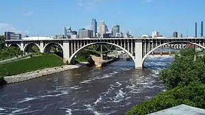 The 10th Avenue Bridge in Minneapolis | |
| Coordinates | 44.9784°N 93.2438°W |
| Carries | Four lanes of automobile traffic |
| Crosses | Mississippi River |
| Locale | Minneapolis, Minnesota |
| Maintained by | Minneapolis |
| ID number | 2796 |
| Characteristics | |
| Design | Concrete rib deck-arch bridge |
| Total length | 2,175 feet (663 m) |
| Width | 68 feet (21 m) |
| Longest span | 266 feet (81 m) |
| Clearance below | 101 feet (31 m) |
| History | |
| Opened | 1929 |
| Location | |

| |
Cedar Avenue Bridge | |
  | |
| Location | Tenth Ave. over Mississippi River, Minneapolis, Minnesota |
|---|---|
| Coordinates | 44.9784°N 93.2438°W |
| Area | 4 acres (1.6 ha) |
| Built | 1929 |
| Architect | Oustad, Kristoffer Olsen |
| Architectural style | Reinforced-concrete bridge |
| MPS | Reinforced-Concrete Highway Bridges in Minnesota MPS |
| NRHP reference No. | 89001845[1] |
| Added to NRHP | November 6, 1989 |
Construction on the bridge began in 1926, and it was completed in 1929. The total length is 2,174.9 feet (662.9 m), with two central spans each 265.5 feet (80.9 m) across. It has an open spandrel arch design, and it is constructed of reinforced concrete. Higher and longer than any preceding bridge in the region, it was originally 2,921 feet (890.3 m) in overall length, 698 feet (213 m) longer than the nearby Third Avenue Bridge. It stands 110 feet (33.5 m) above the water's surface. Cost of the bridge was US$891,000. A major restoration was undertaken in 1972–1976, and the approach spans were altered (they were not considered architecturally significant, even when the bridge was new). The south approach span was relocated to go straight to Washington Avenue.
It was built to alleviate the traffic flows on the bridges serving downtown about a mile upstream. Roads in the vicinity were disrupted by the construction of Interstate 35W and a corresponding bridge (completed 1967; collapsed in 2007) one to two blocks upstream (the famous Seven Corners area of Minneapolis is at the south end). The downstream end of the lower Saint Anthony Falls lock and dam extends under the bridge. The historic Southeast Steam Plant is also nearby.

See also
| Wikimedia Commons has media related to 10th Avenue Bridge. |
References
- Costello, Mary Charlotte (2002). Climbing the Mississippi River Bridge by Bridge, Volume Two: Minnesota. Cambridge, MN: Adventure Publications. ISBN 0-9644518-2-4.
- "National Register Information System". National Register of Historic Places. National Park Service. July 9, 2010.
- (1996). Minnesota's Historic Bridges: Cedar Avenue Bridge. Archived 2005-03-12 at the Wayback Machine Minnesota Historical Society.
Crossings of the Mississippi River | ||||
|---|---|---|---|---|
| ||||