National Register of Historic Places listings in Houston County, Minnesota
This is a list of the National Register of Historic Places listings in Houston County, Minnesota. It is intended to be a complete list of the properties and districts on the National Register of Historic Places in Houston County, Minnesota, United States. The locations of National Register properties and districts for which the latitude and longitude coordinates are included below, may be seen in an online map.
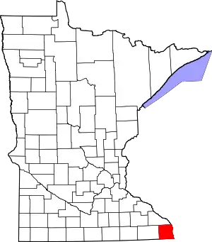
Location of Houston County in Minnesota
There are 16 properties and districts listed on the National Register in the county. A supplementary list includes two sites that were formerly listed on the National Register.
- This National Park Service list is complete through NPS recent listings posted February 5, 2021.[1]
Current listings
| [2] | Name on the Register | Image | Date listed[3] | Location | City or town | Description |
|---|---|---|---|---|---|---|
| 1 | Ballard Hotel |  Ballard Hotel |
November 27, 2017 (#100001841) |
163 West Main Street 43°33′38″N 91°38′18″W |
Spring Grove | Giants of the Earth Norwegian-American Heritage Center |
| 2 | Bridge No. 6679 |  Bridge No. 6679 |
July 20, 2011 (#11000468) |
Minnesota State Highway 76 over the south fork of the Root River 43°44′19″N 91°33′52″W |
Houston vicinity | 1949 steel cantilever bridge—at 300 feet (91 m) the longest in Minnesota upon completion—exemplifying a major post-war advancement in bridge design.[4] |
| 3 | Bridge No. L4013 |  Bridge No. L4013 |
July 5, 1990 (#90000976) |
Township Road 126 over Riceford Creek 43°37′21″N 91°42′21″W |
Spring Grove vicinity | 1915 stone arch bridge, the only documented surviving example of what appears to be a standard design introduced by the state highway commission in the early 20th century.[5] |
| 4 | Christian Bunge, Jr. Store |  Christian Bunge, Jr. Store |
April 6, 1982 (#82002964) |
Iowa Avenue at Main Street 43°30′28″N 91°27′50″W |
Eitzen | Eitzen's most prominent commercial building—built in 1890 for the German immigrant merchant who named the town—and a symbol of the area's ethnic heritage.[6] Now a local history museum.[7] |
| 5 | Caledonia Commercial Historic District |  Caledonia Commercial Historic District |
August 5, 1994 (#94000830) |
101-205 E. Main St. and 101-108 S. Kingston St. 43°38′05″N 91°29′47″W |
Caledonia | Downtown strip with 10 contributing properties built 1872–1906, significant for its late-19th/early-20th-century commercial architecture and its key role in serving Houston County farmers.[8] |
| 6 | Daniel Cameron House |  Daniel Cameron House |
April 6, 1982 (#82002968) |
429-435 South 7th Street 43°49′19″N 91°18′28″W |
La Crescent | Prominent 1871 house noted for its Italianate architecture and associations with Daniel Cameron (a prosperous farmer and state senator) and his brother Peter (the first settler in the area).[9] |
| 7 | Church of the Holy Comforter-Episcopal |  Church of the Holy Comforter-Episcopal |
June 2, 1970 (#70000298) |
Main Street 43°41′39″N 91°16′37″W |
Brownsville | Brownsville's oldest public building, built in 1855 and used as a town hall, church, and school.[10] |
| 8 | Hokah Municipal Building |  Hokah Municipal Building |
October 20, 2014 (#14000868) |
57 Main St. 43°45′34″N 91°20′46″W |
Hokah | 1938 Art Deco hall with government and recreational facilities, a distinctive example of a small-town partnership with the Works Progress Administration for a multipurpose public building.[11] |
| 9 | Houston County Courthouse and Jail | 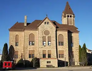 Houston County Courthouse and Jail |
March 18, 1983 (#83000905) |
Courthouse Square 43°37′58″N 91°29′45″W |
Caledonia | 1875 sheriff's residence/jail and 1883 courthouse, noted for their association with Houston County's government and for being its leading examples of Italianate and Romanesque Revival architecture, respectively.[12] |
| 10 | Jefferson Grain Warehouse | 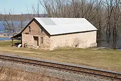 Jefferson Grain Warehouse |
November 25, 1994 (#94001386) |
Off Minnesota Highway 26 43°31′00″N 91°16′46″W |
Jefferson Township | Riverside grain warehouse built in 1868, a rare surviving reminder of a period when wheat was becoming the most important agricultural crop of the Upper Midwest and steamboats were still the leading form of transportation.[13] |
| 11 | Johnson Mill |  Johnson Mill |
April 6, 1982 (#82002966) |
County Roads 5 and 23 43°32′19″N 91°24′45″W |
Eitzen vicinity | One of Minnesota's few surviving water-powered gristmills, built in 1877 to serve the area's wheat farmers.[14] |
| 12 | Portland Prairie Methodist Episcopal Church | 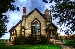 Portland Prairie Methodist Episcopal Church |
April 6, 1982 (#82002967) |
Off Minnesota Highway 76 43°31′33″N 91°29′28″W |
Eitzen vicinity | Rural church built in 1876, noted for its exemplary Eastlake Movement architecture and association with the area's settlers from New England.[15] |
| 13 | Schech Mill | 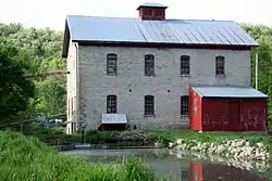 Schech Mill |
January 31, 1978 (#78001548) |
Off County Road 10 43°40′02″N 91°34′50″W |
Caledonia vicinity | Rare surviving watermill built 1875–76, and Minnesota's only gristmill to retain its original millstones and operable 1870s-style machinery.[16] Now a museum.[17] |
| 14 | David R. and Ellsworth A. Sprague Houses |  David R. and Ellsworth A. Sprague Houses |
April 6, 1982 (#82002962) |
204 and 224 West Main Street 43°38′05″N 91°29′55″W |
Caledonia | Two adjacent houses built between 1900 and 1905 for brothers David R. and Ellsworth A. Sprague, who carried on the commercial and financial work of their father, influential Houston County figure Ara D. Sprague (d. 1909).[18] |
| 15 | Spafford Williams Hotel |  Spafford Williams Hotel |
April 6, 1982 (#82002963) |
East Main at North Marshall 43°38′05″N 91°29′46″W |
Caledonia | Hotel established in the early 1870s before the railroad reached Caledonia, representing the city's early commercial activity and architecture.[19] Also a contributing property to the Caledonia Commercial Historic District.[8] |
| 16 | Yucatan Fort Site |  Yucatan Fort Site |
November 14, 1996 (#96001308) |
Address restricted[20] |
Yucatan Township | Blufftop earthworks, a largely intact site that helps illustrate the emergence of agriculture and densifying population along Upper Mississippi tributary valleys during the Oneota period.[21] |
Former listings
| [2] | Name on the Register | Image | Date listed | Date removed | Location | City or town | Summary |
|---|---|---|---|---|---|---|---|
| 1 | Eitzen Stone Barn | April 6, 1982 (#82002965) | November 7, 2016 | South of Eitzen |
Eitzen vicinity | Barn built of fieldstone sometime in the 1870s or '80s, an unusual vernacular use of stonemasonry and a representative of the area's German immigrants and agricultural focus.[22] Also called the Schroeder Stone Barn. Razed in 2004. | |
| 2 | Houston County Poor Farm | April 6, 1982 (#82002961) | May 7, 1990 | Co. Hwy. 12 |
Caledonia vicinity | 1893 poor farm.[23] Demolished in 1988.[24] |
See also
References
- "National Register of Historic Places: Weekly List Actions". National Park Service, United States Department of the Interior. Retrieved on February 5, 2021.
- Numbers represent an alphabetical ordering by significant words. Various colorings, defined here, differentiate National Historic Landmarks and historic districts from other NRHP buildings, structures, sites or objects.
- The eight-digit number below each date is the number assigned to each location in the National Register Information System database, which can be viewed by clicking the number.
- Haun, Katherine; Robert Frame III (2010-03-10). "National Register of Historic Places Registration Form: Bridge No. 6679" (PDF). National Park Service. Retrieved 2012-12-18. Cite journal requires
|journal=(help) - Hess, Jeffrey A. (August 1988). "National Register of Historic Places Registration Form: Bridge No. L4013". National Park Service. Retrieved 2016-09-18. Cite journal requires
|journal=(help) - Frame III, Robert M. (1981-05-28). "Minnesota Historic Properties Inventory Form: Bunge, Christian Jr., Store". National Park Service. Retrieved 2016-09-18. Cite journal requires
|journal=(help) - "Eitzen, MN - Museum". City of Eitzen. Retrieved 2012-12-18.
- Hess, Demian (1993-03-26). "National Register of Historic Places Registration Form: Caledonia Commercial Historic District". National Park Service. Retrieved 2016-09-18. Cite journal requires
|journal=(help) - Frame III, Robert M. (1981-06-01). "Minnesota Historic Properties Inventory Form: Cameron, Daniel, House". National Park Service. Retrieved 2016-09-11. Cite journal requires
|journal=(help) - Grossman, John (1970-04-23). "National Register of Historic Places Inventory – Nomination Form: Emanuel Evangelical Lutheran Church". National Park Service. Retrieved 2016-09-11. Cite journal requires
|journal=(help) - Gaut, Greg (2014-06-05). "National Register of Historic Places Registration Form: Hokah Municipal Building" (PDF). National Park Service. Retrieved 2015-05-25. Cite journal requires
|journal=(help) - Frame III, Robert M. (1981-06-02). "Minnesota Historic Properties Inventory Form: Houston County Courthouse and Jail". National Park Service. Retrieved 2016-09-11. Cite journal requires
|journal=(help) - Anderson, David C. (1980-03-19). "National Register of Historic Places Registration Form: Jefferson Grain Warehouse". National Park Service. Retrieved 2016-05-22. Cite journal requires
|journal=(help) - Frame III, Robert M. (1981-05-28). "Minnesota Historic Properties Inventory Form: Johnson, Charles, Flour Mill ("Upper Mill")". National Park Service. Retrieved 2016-09-11. Cite journal requires
|journal=(help) - Frame III, Robert M. (1981-05-29). "Minnesota Historic Properties Inventory Form: Portland Prairie Methodist Episcopal Church". National Park Service. Retrieved 2016-09-11. Cite journal requires
|journal=(help) - Frame III, Robert M. (1977-06-07). "National Register of Historic Places Inventory -- Nomination Form: Schech's Mill". National Park Service. Retrieved 2016-09-11. Cite journal requires
|journal=(help) - "Schech's Mill". Schech's Mill. 2009. Retrieved 2016-09-11.
- Frame III, Robert M. (1981-06-01). "Minnesota Historic Properties Inventory Form: Sprague (Ellsworth Ara & Robert David) Houses". National Park Service. Retrieved 2016-09-11. Cite journal requires
|journal=(help) - Frame III, Robert M. (1981-06-02). "Minnesota Historic Properties Inventory Form: Williams, Spafford, Hotel (Barnes House)". National Park Service. Retrieved 2016-09-11. Cite journal requires
|journal=(help) - Federal and state laws and practices restrict general public access to information regarding the specific location of this resource. In some cases, this is to protect archeological sites from vandalism, while in other cases it is restricted at the request of the owner. See: Knoerl, John; Miller, Diane; Shrimpton, Rebecca H. (1990), Guidelines for Restricting Information about Historic and Prehistoric Resources, National Register Bulletin, National Park Service, U.S. Department of the Interior, OCLC 20706997.
- Dobbs, Clark A. (October 1994). "National Register of Historic Places Registration Form: Yucatan Fort Site". National Park Service. Cite journal requires
|journal=(help) - Frame III, Robert M. (1981-05-29). "Minnesota Historic Properties Inventory Form: Houston County Courthouse and Jail". National Park Service. Retrieved 2016-09-11. Cite journal requires
|journal=(help) - "Houston County Poor Farm (removed)". Minnesota National Register Properties Database. Minnesota Historical Society. 2009. Retrieved 2012-12-19.
- Nord, Mary Ann (2003). The National Register of Historic Places in Minnesota. Minnesota Historical Society. ISBN 0-87351-448-3.
External links
| Wikimedia Commons has media related to National Register of Historic Places in Houston County, Minnesota. |
- Minnesota National Register Properties Database—Minnesota Historical Society
This article is issued from Wikipedia. The text is licensed under Creative Commons - Attribution - Sharealike. Additional terms may apply for the media files.

