1911 Kebin earthquake
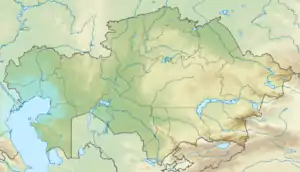
The 1911 Kebin earthquake, or Chon-Kemin earthquake, struck Russian Turkestan on 3 January. Registering at a 7.7 magnitude, it killed 452 people, destroyed more than 770 buildings (which was almost all of the city) in Almaty, Kazakhstan, and resulted in 125 miles (201 km) of surface faulting in the valleys of Chon-Kemin, Chilik and Chon-Aksu.[2]
 | |
| UTC time | 1911-01-03 23:25:48 |
|---|---|
| ISC event | 16958130 |
| USGS-ANSS | ComCat |
| Local date | 4 January 1911 |
| Local time | 05:25 |
| Magnitude | 7.7 Mw |
| Depth | 25 km (16 mi) |
| Epicenter | 43.5°N 77.5°E[1] |
| Areas affected | Kazakhstan, Kyrgyzstan |
| Total damage | Severe[1] |
| Max. intensity | X (Extreme)[1] |
| Casualties | 452 |

Damage
Most of the region's inhabitants lived in yurts, which are relatively resistant to earthquakes and unlikely to cause deaths even if they do collapse. The greatest damage and most of the casualties resulted from landslides triggered by the earthquake, with 452 people killed and another 740 people injured.[3] Nearly 1,100 houses and 4,545 yurts were destroyed by the earthquake and the resulting landslides.[3]
Tectonic setting
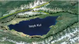
The Tien Shan mountains form part of the broad zone of deformation associated with the continuing collision between the Indian Plate and the Eurasian Plate. In the region around Issyk Kul, the tectonic regime is a combination of thrusting and sinistral strike-slip. The lake is formed in a ramp basin bounded to both north and south by opposite verging thrust faults, while the major Chon-Kemin–Chilik strike-slip fault runs along the linear valleys to the north.[4]
Characteristics
In the Chong-Kemin and Chilik valleys, and on the shoreline of Issyk Kul, a complex zone of surface rupture was identified by fieldwork immediately following the earthquake. Two main zones of rupture were noted, one complex zone along the Chon-Kemin and Chilik valleys, the other along the Chon-Aksu valley.[5]
Chon-Kemin Chilik rupture zone
This complex zone of ruptures has four main segments: the 20 km long Dzhil'-Aryk, the 62 km long Lower Chon-Kemin, south side, the 40 km long Lower Chon-Kemin, north side and the 66 km long Upper Chon-Kemin-Chilik zone. The Dzhil'-Aryk segment shows evidence of reverse faulting on a south-dipping fault plane, with no clear evidence of lateral movement. The sense of displacement along the rest of the near-vertical Chon-Kemin and Chilik rupture zone was dominantly of sinistral (left lateral) strike-slip with minor amounts of reverse faulting, with between one and three metres of vertical displacement. Left-lateral displacements of up to 40 m recognised from the offset of river channels, represent cumulative displacements and no separate estimates have been obtained for the 1911 event.[4]
Chon-Aksu Aksu rupture zone
This zone has two parts: the 40 km long Chon-Aksu segment and the 34 km long Aksu segment. Along the Chon-Aksu valley the movement was dominantly reverse in type along a 60° north-dipping reverse fault, with up to 10.5 m vertical displacement and at most 1 m horizontal displacement, from the lack of observed offset of river thalwegs. The outcrop pattern of the Aksu segment rupture indicates a low-angle thrust, possibly steepening with depth, with a maximum vertical offset or 3–5 m, decreasing steadily to the east.[4] In total about 200 km of fault surfaces ruptured, although there was no visible faulting joining the two main rupture zones.[5]
Landslides
Many landslides and rock avalanches were triggered by the earthquake and are associated with the mapped zones of surface rupture.[4] The two largest landslides were the Kaindy rock avalanche and the Ananevo rockslide. The Kaindy landslide, with a volume of 15 x 106 m3, was formed of a mass of limestone that buried a group of yurts and killed 38 people. The Ananevo rockslide also had a volume of about 15 x 106 m3, and was formed of weathered granitic material, with a 250 m high backscarp that is still visible.[6]
See also
References
- NGDC. "Comments for the Significant Earthquake". Retrieved 27 August 2010.
- "Today in Earthquake History: January 3". United States Geological Survey. 27 October 2009. Archived from the original on 23 January 2010. Retrieved 3 January 2010.
- Abdrachmatov, K.E.; Djanuzakov, K.D.; Delvaux, D. (2002). "Active tectonics and seismic hazard of the Issyk-Kul Basin in the Kyrgyz Tian-Shan". In Klerkx J.; Imanackunov B. (eds.). Lake Issyk-Kul: its natural environment. NATO science series: Earth and environmental sciences. 13. Springer. p. 156. ISBN 978-1-4020-0899-3.
- Delvaux, D.; Abdrakhmatov K.E.; Lemzin I.N. & Strom A.L. (2001). "Landslides and surface breaks of the 1911 Ms 8.2 Kemin earthquake" (PDF). Russian Geology and Geophysics. 42 (10): 1583–1592. Retrieved 29 December 2010.
- Arrowsmith, J.R.; Crosby C.J.; Korjenkov A.M.; Mamyrov E. & Povolotskaya I. (2005). "Surface rupture of the 1911 Kebin (Chon-Kemin) earthquake, Northern Tien Shan, Kyrgyzstan". American Geophysical Union, Fall Meeting. 51: #T51F–05. Bibcode:2005AGUFM.T51F..05A.
- Havenith, H.-B.; Strom A.; Jongmans D.; Abdrakhmatov K.; Delvaux D. & Tréfois P. (2003). "Seismic triggering of landslides, Part A: Field evidence from the Northern Tien Shan" (PDF). Natural Hazards and Earth System Sciences. European Geosciences Union. 3: 135–149. doi:10.5194/nhess-3-135-2003. Retrieved 30 December 2010.
External links
- The International Seismological Centre has a bibliography and/or authoritative data for this event.