1995 Pacific typhoon season
The 1995 Pacific typhoon season occurred all year round, unusual in that most tropical cyclones tend to form in the northwestern Pacific Ocean between May and November.[1]
| 1995 Pacific typhoon season | |
|---|---|
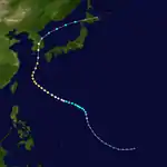
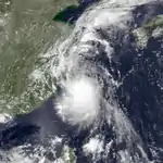
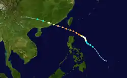
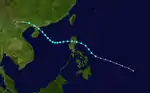
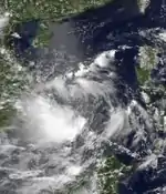
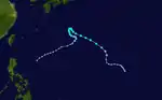
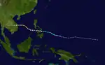
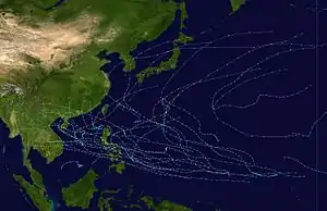 Season summary map | |
| Seasonal boundaries | |
| First system formed | January 7, 1995 |
| Last system dissipated | December 31, 1995 |
| Strongest storm | |
| Name | Angela |
| • Maximum winds | 215 km/h (130 mph) (10-minute sustained) |
| • Lowest pressure | 910 hPa (mbar) |
| Seasonal statistics | |
| Total depressions | 47 |
| Total storms | 24 |
| Typhoons | 8 |
| Super typhoons | 5 (unofficial) |
| Total fatalities | 1,314 |
| Total damage | $1.21 billion (1995 USD) |
| Related articles | |
The scope of this article is limited to the Pacific Ocean, north of the equator and west of the international date line. Storms that form east of the date line and north of the equator are called hurricanes; see 1995 Pacific hurricane season. Tropical storms formed in the entire west Pacific basin were assigned a name by the Joint Typhoon Warning Center. Tropical depressions in this basin have the "W" suffix added to their number. Tropical depressions that enter or form in the Philippine area of responsibility are assigned a name by the Philippine Atmospheric, Geophysical and Astronomical Services Administration or PAGASA. This can often result in the same storm having two names.
Season summary
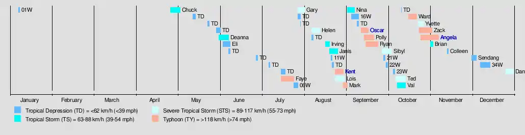
31 tropical cyclones formed this year in the Western Pacific, of which 26 became tropical storms. 8 storms reached typhoon intensity, five of them achieving super typhoon strength.
Systems
Tropical Depression 01W
| Tropical depression (SSHWS) | |
  | |
| Duration | January 7 (entered basin) – January 8 |
|---|---|
| Peak intensity | 55 km/h (35 mph) (1-min) 1000 hPa (mbar) |
A circulation started to develop and spawned a tropical disturbance near the equator but east of the International Dateline on December 30, 1994. The system remained stationery for several days until it finally gathered some warm waters and low to moderate windshear on January 5. With that, the JTWC classified it as Tropical Depression 01W as it crossed the basin early on January 7. Moving northeastwards, it entered an area of high vertical windshear, cool waters and weak convection and dissipated on January 9.
Tropical Storm Chuck
| Tropical storm (JMA) | |
| Tropical storm (SSHWS) | |
  | |
| Duration | April 27 – May 4 |
|---|---|
| Peak intensity | 65 km/h (40 mph) (10-min) 998 hPa (mbar) |
Chuck stayed from land.
Tropical Storm Deanna (Auring)
| Tropical storm (JMA) | |
| Tropical storm (SSHWS) | |
  | |
| Duration | June 1 – June 8 |
|---|---|
| Peak intensity | 75 km/h (45 mph) (10-min) 996 hPa (mbar) |
Deanna did a loop in the northeastern South China Sea.
Tropical Storm Eli
| Tropical depression (JMA) | |
| Tropical storm (SSHWS) | |
  | |
| Duration | June 4 – June 9 |
|---|---|
| Peak intensity | 55 km/h (35 mph) (10-min) 1002 hPa (mbar) |
Eli stayed at sea.
Typhoon Faye (Bebeng)
| Typhoon (JMA) | |
| Category 3 typhoon (SSHWS) | |
  | |
| Duration | July 16 – July 25 |
|---|---|
| Peak intensity | 140 km/h (85 mph) (10-min) 950 hPa (mbar) |
Tropical Depression 05W formed on July 15 and was named Faye the next day as it intensified into a tropical storm. On July 19, Faye became the first typhoon of the season, tied for the second latest date of the first typhoon with 1977, only behind Otto of 1998. It tracked northwestward and eventually reached a peak of 120 mph (205 km/h) 1-min winds and a minimum pressure of 950 millibars. Faye turned northward, and after weakening slightly it hit the south coast of South Korea on the 23rd, before accelerating east-northeastwards and becoming extratropical.[2] 16 people were reported dead, with moderate damage from flooding.[3]
On July 23, 1995, when the typhoon passed South Korea, a rogue wave hitting Pusan Harbor, the largest port in South Korea, resulting in two ships collided.[4][5]
Tropical Depression 06W
| Tropical depression (JMA) | |
| Tropical storm (SSHWS) | |
  | |
| Duration | July 25 – July 28 |
|---|---|
| Peak intensity | 55 km/h (35 mph) (10-min) 1004 hPa (mbar) |
6W passed close to the Philippines.
Severe Tropical Storm Gary
| Severe tropical storm (JMA) | |
| Category 1 typhoon (SSHWS) | |
  | |
| Duration | July 28 – August 2 |
|---|---|
| Peak intensity | 100 km/h (65 mph) (10-min) 980 hPa (mbar) |
On July 27, an area of low pressure near the Philippines later strengthened into Tropical Depression Gary. On July 28, Gary further strengthened into a tropical storm. After bringing torrential downpours and flooding to the Philippines, Gary moved northwest into the South China Sea. Gary intensified even further into a severe tropical storm on July 30 and made landfall near Shantou on July 31. On August 2, after moving inland, Gary dissipated.
Gary claimed four lives in Shantou. Near Taiwan, four fishing vessels sank, with two people dead and 19 others missing.[6]
Severe Tropical Storm Helen (Karing)
| Severe tropical storm (JMA) | |
| Category 1 typhoon (SSHWS) | |
  | |
| Duration | August 7 – August 13 |
|---|---|
| Peak intensity | 110 km/h (70 mph) (10-min) 985 hPa (mbar) |
On August 7, Helen formed as a tropical depression about 1200 km east of Manila. Moving northwestwards, Helen soon intensified into a tropical storm on August 9. On August 11, Helen further intensified into a typhoon and made landfall about 60 km northeast of Hong Kong. On August 13, Helen rapidly weakened and soon dissipated.
In Guangdong Helen claimed 23 lives. It also brought many landslides and flooding.[6]
Tropical Storm Irving (Diding)
| Tropical storm (JMA) | |
| Tropical storm (SSHWS) | |
  | |
| Duration | August 17 – August 20 |
|---|---|
| Peak intensity | 85 km/h (50 mph) (10-min) 990 hPa (mbar) |
On August 17, an area of low pressure in the South China Sea became Tropical Depression Irving. The following morning, Irving became a tropical storm and moved north at 15 km/h. On August 20, Irving again became a tropical depression, and made landfall on the Leizhou Peninsula. Irving then started losing strength rapidly and soon dissipated.[6]
Tropical Storm Janis (Etang)
| Tropical storm (JMA) | |
| Tropical storm (SSHWS) | |
  | |
| Duration | August 20 – August 26 |
|---|---|
| Peak intensity | 85 km/h (50 mph) (10-min) 990 hPa (mbar) |
An active monsoon trough developed Tropical Storm Janis, forming on August 17 and becoming a tropical storm on the 21st. Another tropical depression to Janis's west merged with the storm, weakening it rather than the typical strengthening after a merger. Janis continued northwestward, eventually restrengthening to a 65 mph tropical storm before hitting eastern China. It recurved to the northeast, and hit near Seoul, South Korea, on the 26th. The storm brought more rain to an area hit by a typhoon only a month before, causing an additional 45 deaths and $428.5 million in damage.
Tropical Depression 11W
| Tropical depression (SSHWS) | |
| Tropical depression (SSHWS) | |
  | |
| Duration | August 21 – August 22 |
|---|---|
| Peak intensity | 45 km/h (30 mph) (1-min) 1002 hPa (mbar) |
11W did not last for long.
Typhoon Kent (Gening)
| Typhoon (JMA) | |
| Category 4 super typhoon (SSHWS) | |
  | |
| Duration | August 24 – August 30 |
|---|---|
| Peak intensity | 155 km/h (100 mph) (10-min) 945 hPa (mbar) |
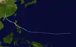
A tropical wave was detected by the Joint Typhoon Warning Center on August 24. On August 25, it was classified as Tropical Depression 12W by the JTWC.[7] The Japan Meteorological Agency (JMA) also upgraded the disturbance to a tropical depression later that day.[8] At the same time, the Philippine Atmospheric, Geophysical and Astronomical Services Administration (PAGASA) named 12W, Gening from its list of pacific typhoon names.[9] On August 26, Gening intensified into a tropical storm and was named Kent by the Joint Typhoon Warning Center.[7] Kent then quickly intensified into a typhoon on August 27 as it drifted slowly west-northwest. It quickly intensified and reached peak intensity as a Category 4 super typhoon on August 29. The storm also reached a low barometric pressure of 945 millibars during that time.[7] Continuing west-northwest, the eye of Typhoon Kent passed over the Philippine island of Basco. Kent then undergo an eyewall replacement cycle later that day and started to weaken. Kent also weakened below super typhoon status as it accelerated towards China.[7] Kent made landfall in China on August 31 50 miles (95 km) northeast of Hong Kong. After landfall, the Joint Typhoon Warning Center issued its final warning on September 1 as Kent dissipated.[7] The Japan Meteorological Agency also issued its final advisory on Kent.[8]
Kent caused 52 casualties, as well as $89 million in damage (1995 USD).
Severe Tropical Storm Lois
| Severe tropical storm (JMA) | |
| Category 1 typhoon (SSHWS) | |
  | |
| Duration | August 24 – August 31 |
|---|---|
| Peak intensity | 95 km/h (60 mph) (10-min) 980 hPa (mbar) |
Lois hit Vietnam as a typhoon.
Typhoon Mark
| Typhoon (JMA) | |
| Category 2 typhoon (SSHWS) | |
  | |
| Duration | August 30 – September 2 |
|---|---|
| Peak intensity | 120 km/h (75 mph) (10-min) 985 hPa (mbar) |
Mark raced off the northeast away from land.
Tropical Storm Nina (Helming)
| Tropical storm (JMA) | |
| Tropical storm (SSHWS) | |
  | |
| Duration | September 2 – September 7 |
|---|---|
| Peak intensity | 75 km/h (45 mph) (10-min) 992 hPa (mbar) |
Nina hit the Philippines and China.
Tropical Depression 16W
| Tropical depression (HKO) | |
| Tropical depression (SSHWS) | |
  | |
| Duration | September 5 – September 10 |
|---|---|
| Peak intensity | 45 km/h (30 mph) (10-min) 1005 hPa (mbar) |
16W was a weak but long lived depression that passed through the Philippines.
Typhoon Oscar
| Typhoon (JMA) | |
| Category 5 super typhoon (SSHWS) | |
  | |
| Duration | September 12 – September 17 |
|---|---|
| Peak intensity | 185 km/h (115 mph) (10-min) 925 hPa (mbar) |
In Tokyo, numerous buildings sustained severe damage from high winds and several major highways were shut down. At least 20 people were injured by flying debris in Japan.[10] One person was killed in a landslide and another drowned in a flood. Seven more people were killed by Typhoon Oscar throughout the country.[11] Three other people were also listed as missing due to the storm.[12] Losses from the storm throughout Japan amounted to 612.3 million yen (US$6.7 million).
Typhoon Polly (Ising)
| Typhoon (JMA) | |
| Category 2 typhoon (SSHWS) | |
  | |
| Duration | September 14 – September 21 |
|---|---|
| Peak intensity | 140 km/h (85 mph) (10-min) 960 hPa (mbar) |
Polly recurved out to sea.
Typhoon Ryan (Luding)
| Typhoon (JMA) | |
| Category 4 super typhoon (SSHWS) | |
  | |
| Duration | September 15 – September 24 |
|---|---|
| Peak intensity | 155 km/h (100 mph) (10-min) 940 hPa (mbar) |
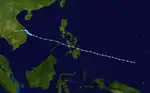
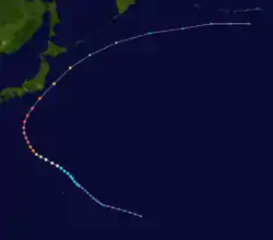
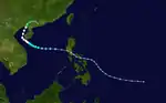
The monsoon trough spawned a tropical depression over the South China Sea on September 14. It drifted northwestward, becoming a tropical storm on the 16th and a typhoon on the 19th. As Ryan turned northeastward, it rapidly intensified to become a super typhoon on the 21st, the first ever to form and reach that intensity in the South China Sea. The super typhoon passed south of Taiwan, and weakened to a 110 mph typhoon as it made landfall on southwestern Japan on the 23rd. Ryan only caused 5 deaths on its path.[13]
Severe Tropical Storm Sibyl (Mameng)
| Severe tropical storm (JMA) | |
| Category 2 typhoon (SSHWS) | |
  | |
| Duration | September 27 – October 4 |
|---|---|
| Peak intensity | 95 km/h (60 mph) (10-min) 985 hPa (mbar) |
108 fatalities and $38.5 million in damage (1995 USD) can be attributed to Typhoon Sibyl as it crossed the central Philippines on September 29. Sibyl actually strengthened while passing through the archipelago due to the contraction of the wind field.
Tropical Depression 21W
| Tropical depression (SSHWS) | |
| Tropical depression (SSHWS) | |
 | |
| Duration | September 28 – September 29 |
|---|---|
| Peak intensity | 45 km/h (30 mph) (1-min) 1006 hPa (mbar) |
21W did not last long.
Tropical Depression 22W
| Tropical depression (SSHWS) | |
| Tropical depression (SSHWS) | |
 | |
| Duration | September 30 – October 1 |
|---|---|
| Peak intensity | 55 km/h (35 mph) (1-min) 1016 hPa (mbar) |
22W was only tracked by the JTWC.
Tropical Depression 23W
| Tropical depression (SSHWS) | |
 | |
| Duration | October 5 – October 6 |
|---|---|
| Peak intensity | 45 km/h (30 mph) (1-min) 1004 hPa (mbar) |
23W lasted a day.
Severe Tropical Storm Ted
| Severe tropical storm (JMA) | |
| Category 1 typhoon (SSHWS) | |
  | |
| Duration | October 7 – October 14 |
|---|---|
| Peak intensity | 95 km/h (60 mph) (10-min) 990 hPa (mbar) |
Ted hit China.
Tropical Storm Val
| Tropical storm (JMA) | |
| Tropical storm (SSHWS) | |
 | |
| Duration | October 8 – October 14 |
|---|---|
| Peak intensity | 75 km/h (45 mph) (10-min) 996 hPa (mbar) |
Val moved erratically over open water.
Typhoon Ward (Neneng)
| Typhoon (JMA) | |
| Category 5 super typhoon (SSHWS) | |
  | |
| Duration | October 16 – October 22 |
|---|---|
| Peak intensity | 155 km/h (100 mph) (10-min) 940 hPa (mbar) |
Ward recurved out to sea.
Severe Tropical Storm Yvette (Oniang)
| Severe tropical storm (JMA) | |
| Category 1 typhoon (SSHWS) | |
 | |
| Duration | October 23 – October 27 |
|---|---|
| Peak intensity | 95 km/h (60 mph) (10-min) 985 hPa (mbar) |
Yvette hit Vietnam as a severe tropical storm.
Typhoon Zack (Pepang)
| Typhoon (JMA) | |
| Category 4 typhoon (SSHWS) | |
  | |
| Duration | October 24 – November 2 |
|---|---|
| Peak intensity | 165 km/h (105 mph) (10-min) 950 hPa (mbar) |
Like Sibyl, Zack strengthened while crossing the central Philippines on October 28. The typhoon continued to intensify over the South China Sea to a 140 mph storm, but weakened to a 115 mph typhoon as it made landfall on eastern Vietnam on the 1st. Zack caused 110 deaths and heavy damage from flooding.
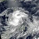
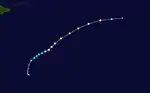
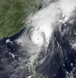
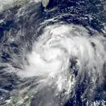
Typhoon Angela (Rosing)
| Typhoon (JMA) | |
| Category 5 super typhoon (SSHWS) | |
  | |
| Duration | October 25 – November 7 |
|---|---|
| Peak intensity | 215 km/h (130 mph) (10-min) 910 hPa (mbar) |
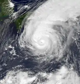
The monsoon trough that developed Yvette and Zack spawned another tropical depression on October 25. It moved to the west, organizing very slowly to become a tropical storm on the 26th. 2 days later Angela became a typhoon, and from the 31st to the 1st Angela rapidly intensified to a 180 mph (290 km/h) super typhoon. It maintained that intensity as it moved westward, hitting the Philippines on the 2nd as a slightly weaker 160 mph (260 km/h) storm. Angela continued to the west-northwest, where upper level winds caused it to dissipate on the 7th over the Gulf of Tonkin. Angela caused 9.33 billion Philippine Pesos (1995 pesos) in damage across the Philippines, resulting in 882 fatalities.[14]
Tropical Storm Brian
| Tropical storm (JMA) | |
| Tropical storm (SSHWS) | |
 | |
| Duration | November 1 – November 3 |
|---|---|
| Peak intensity | 75 km/h (45 mph) (10-min) 998 hPa (mbar) |
Brian stayed away from land.
Tropical Storm Colleen
| Tropical depression (JMA) | |
| Tropical storm (SSHWS) | |
 | |
| Duration | November 13 (entered basin) – November 14 |
|---|---|
| Peak intensity | 55 km/h (35 mph) (10-min) 1004 hPa (mbar) |
Collen stayed at sea.
Tropical Depression 32W/33W (Sendang)
| Tropical depression (PAGASA) | |
| Tropical depression (SSHWS) | |
 | |
| Duration | December 1 – December 4 |
|---|---|
| Peak intensity | 55 km/h (35 mph) (10-min) 1004 hPa (mbar) |
Tropical Depressions 32W and 33W, though operationally treated as two separate cyclones, were in actuality one system; a relative rare event that shows the difficulties of tracking poorly organized storms. 32 developed on November 30 east of the Philippines. Operationally it was said to have tracked to the northeast and dissipated, with a second area of convection to the west becoming 33W. 32's convection became disorganized with the shower activity heading northeastward, but the low level circulation remained behind and headed westward to be called 33. The depression headed west-southwest, where it brought heavy rain to the Philippines on the 4th and 5th, killing 14 people. The most recent example prior to this system that had two names was Tropical Storm Ken-Lola in the 1989 Pacific typhoon season.


Storm names
During the season 24 named tropical cyclones developed in the Western Pacific and were named by the Joint Typhoon Warning Center, when it was determined that they had become tropical storms. These names were contributed to a revised list from mid-1989. However this is the last season using this naming list since the JTWC revised a new naming list in 1996.
| Chuck | Deanna | Eli | Faye | Gary | Helen | Irving | Janis | Kent | Lois | Mark | Nina |
| Oscar | Polly | Ryan | Sibyl | Ted | Val | Ward | Yvette | Angela | Brian | Colleen | Dan |
Philippines
| Auring | Bebeng | Karing | Diding | Etang |
| Gening | Helming | Ising | Luding | Mameng |
| Neneng | Oniang | Pepang | Rosing | Sendang |
| Trining | Ulding (unused) | Warling (unused) | Yayang (unused) | |
| Auxiliary list | ||||
|---|---|---|---|---|
| Ading (unused) | ||||
| Barang (unused) | Krising (unused) | Dadang (unused) | Erling (unused) | Goying (unused) |
The Philippine Atmospheric, Geophysical and Astronomical Services Administration uses its own naming scheme for tropical cyclones in their area of responsibility. PAGASA assigns names to tropical depressions that form within their area of responsibility and any tropical cyclone that might move into their area of responsibility. Should the list of names for a given year prove to be insufficient, names are taken from an auxiliary list, the first 10 of which are published each year before the season starts. Names not retired from this list will be used again in the 1999 season. This is the same list used for the 1991 season. PAGASA uses its own naming scheme that starts in the Filipino alphabet, with names of Filipino female names ending with "ng" (A, B, K, D, etc.). Names that were not assigned/going to use are marked in gray.
Retirement
Due to an extreme death toll caused by Typhoon Rosing in the Philippines, PAGASA later retired the name Rosing and was replaced by Rening for the 1999 season.
Season effects
This table summarizes all the systems that developed within or moved into the North Pacific Ocean, to the west of the International Date Line during 1995. The tables also provide an overview of a systems intensity, duration, land areas affected and any deaths or damages associated with the system.
| Name | Dates active | Peak classification | Sustained wind speeds |
Pressure | Areas affected | Damage (USD) |
Deaths | Refs |
|---|---|---|---|---|---|---|---|---|
| 01W | January 7 – 8 | Tropical depression | 55 km/h (35 mph) | 1000 hPa (29.53 inHg) | Marshall Islands | None | None | |
| Chuck | April 27 – May 4 | Tropical storm | 65 km/h (40 mph) | 998 hPa (29.47 inHg) | Marshall Islands, Caroline Islands | None | None | |
| TD | May 13 – 15 | Tropical depression | Not specified | 996 hPa (29.41 inHg) | Ryukyu Islands | None | None | |
| TD | May 24 – 25 | Tropical depression | Not specified | 1008 hPa (29.77 inHg) | None | None | None | |
| TD | May 30 – June 2 | Tropical depression | 55 km/h (35 mph) | 1004 hPa (29.65 inHg) | South China | None | None | |
| Deana (Auring) | June 1 – 8 | Tropical storm | 75 km/h (45 mph) | 996 hPa (29.41 inHg) | Philippines, Taiwan, Ryukyu Islands | None | None | |
| Eli | June 4 – 9 | Tropical depression | 75 km/h (45 mph) | 1002 hPa (29.59 inHg) | None | None | None | |
| TD | June 8 – 9 | Tropical depression | Not specified | 1000 hPa (29.53 inHg) | South China | None | None | |
| TD | June 28 – 29 | Tropical depression | Not specified | 1004 hPa (29.65 inHg) | Vietnam | None | None | |
| TD | July 7 – 8 | Tropical depression | Not specified | 1000 hPa (29.53 inHg) | None | None | None | |
| TD | July 16 – 19 | Tropical depression | Not specified | 1006 hPa (29.71 inHg) | Vietnam | None | None | |
| Faye | July 16 – 25 | Typhoon | 140 km/h (85 mph) | 950 hPa (28.05 inHg) | Mariana Islands, Ryukyu Islands, Korean Peninsula | Unknown | 16 | |
| 06W | July 25 – 28 | Tropical depression | 65 km/h (40 mph) | 1004 hPa (29.65 inHg) | Philippines | None | None | |
| Gary (Bebeng) | July 28 – August 2 | Severe tropical storm | 100 km/h (65 mph) | 980 hPa (28.94 inHg) | Philippines, China | None | 2 | |
| TD | July 28 – 30 | Tropical depression | Not specified | 998 hPa (29.47 inHg) | South China, Vietnam | None | None | |
| TD | July 30 | Tropical depression | Not specified | 1016 hPa (30.01 inHg) | None | None | None | |
| Helen (Karing) | August 7 – 13 | Severe tropical storm | 110 km/h (70 mph) | 985 hPa (29.09 inHg) | Philippines, South China | None | 23 | |
| TD | August 7 – 8 | Tropical depression | Not specified | 1010 hPa (29.83 inHg) | None | None | None | |
| Irving (Diding) | August 17 – 20 | Tropical storm | 85 km/h (50 mph) | 90 hPa (29.23 inHg) | South China | None | None | |
| Janis (Etang) | August 20 – 26 | Tropical storm | 75 km/h (45 mph) | 996 hPa (29.41 inHg) | Philippines, Taiwan, Ryukyu Islands, Korean Peninsula | $429 million | 45 | |
| 11W | August 21 – 22 | Tropical depression | 45 km/h (30 mph) | 1002 hPa (29.59 inHg) | Ryukyu Islands | None | None | |
| TD | August 22 – 23 | Tropical depression | Not specified | 1002 hPa (29.83 inHg) | None | None | None | |
| Kent (Gening) | August 24 – 30 | Typhoon | 155 km/h (100 mph) | 945 hPa (27.91 inHg) | Philippines, Taiwan, China | $419 million | 52 | |
| Lois | August 24 – 31 | Severe tropical storm | 95 km/h (60 mph) | 980 hPa (28.94 inHg) | South China, Vietnam, Laos, Thailand | None | None | |
| Mark | August 30 – September 2 | Typhoon | 120 km/h (75 mph) | 985 hPa (29.09 inHg) | None | None | None | |
| Nina (Helming) | September 2 – 7 | Tropical storm | 75 km/h (45 mph) | 992 hPa (29.29 inHg) | Philippines, South Korea | None | None | |
| 16W | September 5 – 10 | Tropical depression | 45 km/h (30 mph) | 1006 hPa (29.71 inHg) | Vietnam | None | None | |
| TD | September 9 – 10 | Tropical depression | Not specified | 1006 hPa (29.71 inHg) | None | None | None | |
| Oscar | September 12 – 17 | Typhoon | 185 km/h (115 mph) | 925 hPa (27.32 inHg) | Mariana Islands, Japan | $6.7 million | 8 | |
| Polly (Ising) | September 14 – 21 | Typhoon | 140 km/h (85 mph) | 960 hPa (28.35 inHg) | None | None | None | |
| Ryan (Luding) | September 15 – 24 | Typhoon | 155 km/h (100 mph) | 940 hPa (27.46 inHg) | Philippines, Taiwan, Japan | None | None | |
| Sibyl (Mameng) | September 27 – October 4 | Severe tropical storm | 95 km/h (60 mph) | 985 hPa (28.95 inHg) | Philippines, China | $38.5 million | 108 | |
| 21W | September 28 – 29 | Tropical depression | 55 km/h (35 mph) | 1006 hPa (29.71 inHg) | Vietnam | None | None | |
| 22W | September 30 – October 1 | Tropical depression | 55 km/h (35 mph) | 1016 hPa (30.01 inHg) | None | None | None | |
| 23W | October 5 – 6 | Tropical depression | 45 km/h (30 mph) | 1004 hPa (29.65 inHg) | Vietnam | None | None | |
| Ted | October 7 – 14 | Severe tropical storm | 95 km/h (60 mph) | 990 hPa (29.23 inHg) | Philippines, South China | None | None | |
| Val | October 8 – 14 | Tropical storm | 75 km/h (45 mph) | 996 hPa (29.41 inHg) | Mariana Islands | None | None | |
| TD | October 11 | Tropical depression | Not specified | 1006 hPa (29.71 inHg) | None | None | None | |
| Ward (Neneng) | October 16 – 22 | Typhoon | 155 km/h (100 mph) | 940 hPa (27.46 inHg) | Mariana Islands | None | None | |
| Yvette (Oniang) | October 23 – 27 | Severe tropical storm | 95 km/h (60 mph) | 985 hPa (28.95 inHg) | Philippine, Vietnam, Cambodia, Laos, Thailand | Unknown | Unknown | |
| Zack (Pepang) | October 24 – November 2 | Typhoon | 165 km/h (105 mph) | 950 hPa (28.05 inHg) | Caroline Islands, Philippines, Vietnam, Cambodia | None | 110 | |
| Angela (Rosing) | October 25 – November 7 | Typhoon | 215 km/h (130 mph) | 910 hPa (26.87 inHg) | Caroline Islands, Philippines, South China, Vietnam | $315 million | 936 | |
| Brian | November 1 – 3 | Tropical storm | 75 km/h (45 mph) | 998 hPa (29.47 inHg) | Mariana Islands | None | None | |
| Colleen | November 13 – 14 | Tropical depression | 65 km/h (40 mph) | 1004 hPa (29.65 inHg) | None | None | None | |
| 32W/33W (Sendang) | December 1 – 4 | Tropical depression | 55 km/h (35 mph) | 1004 hPa (29.65 inHg) | Philippines | None | 14 | |
| 34W | December 7 – 14 | Tropical depression | 65 km/h (40 mph) | 1002 hPa (29.59 inHg) | Vietnam | None | None | |
| Dan (Trining) | December 25 – 31 | Severe tropical storm | 100 km/h (65 mph) | 985 hPa (28.95 inHg) | Caroline Islands, Philippines | Unknown | Unknown | |
| Season aggregates | ||||||||
| 47 systems | January 7 – December 31 | 215 km/h (130 mph) | 910 hPa (26.87 inHg) | 1.21 billion | 1314 | |||
See also
- 1995 Pacific hurricane season
- 1995 Atlantic hurricane season
- 1995 North Indian Ocean cyclone season
- South-West Indian Ocean cyclone season: 1994-95, 1995-96
- Australian region cyclone season: 1994-95, 1995-96
- South Pacific cyclone season: 1994-95, 1995-96
References
- Gary Padgett. May 2003 Tropical Cyclone Summary. Archived September 25, 2006, at the Wayback Machine Retrieved 2006-08-26.
- "Best Track of Typhoon 05W (1995)". Joint Typhoon Warning Center. Retrieved November 25, 2015.
- David Longshore (2008). "Faye, Typhoon Japan–Korea July 19–25, 1995". Encyclopedia of Hurricanes, Typhoons, and Cyclones, New Edition. New York: Facts on File. p. 176. ISBN 9781438118796. Retrieved 31 October 2015.
- "AT LEAST 13 DIE AS TYPHOON FAYE FLAILS S. KOREA". Deseret News. Associated Press. July 24, 1995. Retrieved November 15, 2020.
- World's Deadliest Storms (Television special). United States: Nash Entertainment. 1999. Retrieved November 15, 2020 – via YouTube.
- "Tropical Cyclones In 1995" (PDF). Royal Observatory Hong Kong. Retrieved 30 October 2015.
- Joint Typhoon Warning Center (1995). "JWTC Report on Kent" (PDF). United States Navy. Archived from the original (PDF) on 2011-06-07. Retrieved 2007-05-01.
- Japan Meteorological Agency (1995). "JMA Best Track Data". Archived from the original on 2008-05-21. Retrieved 2007-05-07.
- Relief Web (2007). "Philippine Situation report 1". Retrieved 2007-05-08.
- https://news.google.com/newspapers?nid=1310&dat=19950917&id=7HAVAAAAIBAJ&sjid=E-sDAAAAIBAJ&pg=6782,4270002
- https://news.google.com/newspapers?id=SlUNAAAAIBAJ&sjid=pW4DAAAAIBAJ&pg=7052,7772105
- https://www.nytimes.com/1995/09/18/world/world-news-briefs-typhoon-just-nudges-japan-killing-at-least-2.html
- "Hurricane Ryan: 09/14/1995 - 09/25/1995". Weather Underground. Retrieved 2018-07-05.
- Philippine Atmospheric Geophysical and Astronomical Services Administration. Most Destructive Tropical Cyclones for Month of October. Archived May 11, 2004, at the Wayback Machine Retrieved on 2007-02-04.
External links
- Japan Meteorological Agency
- Joint Typhoon Warning Center.
- China Meteorological Agency
- National Weather Service Guam
- Hong Kong Observatory
- Macau Meteorological Geophysical Services
- Korea Meteorological Agency
- Philippine Atmospheric, Geophysical and Astronomical Services Administration
- Taiwan Central Weather Bureau
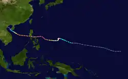
- Satellite movie of 1995 Pacific typhoon season
Tropical cyclones of the 1995 Pacific typhoon season | ||||||||||||||||||||||||||||||||||||||||||||||||||||||||||||||||||||||||
|---|---|---|---|---|---|---|---|---|---|---|---|---|---|---|---|---|---|---|---|---|---|---|---|---|---|---|---|---|---|---|---|---|---|---|---|---|---|---|---|---|---|---|---|---|---|---|---|---|---|---|---|---|---|---|---|---|---|---|---|---|---|---|---|---|---|---|---|---|---|---|---|---|
|
| |||||||||||||||||||||||||||||||||||||||||||||||||||||||||||||||||||||||
| ||||||||||||||||||||||||||||||||||||||||||||||||||||||||||||||||||||||||