Aceitunas
Aceitunas is a barrio in the municipality of Moca, Puerto Rico with a population of 3,098 in 2010. The land area of this subdivision is 5.36 square miles (13.9 km2).[3][4][5]
Aceitunas | |
|---|---|
Barrio | |
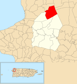 Location of Aceitunas within the municipality of Moca shown in red | |
 Aceitunas Location of Puerto Rico | |
| Coordinates: 18°26′17″N 67°04′01″W[1] | |
| Commonwealth | |
| Municipality | |
| Area | |
| • Total | 5.36 sq mi (13.9 km2) |
| • Land | 5.36 sq mi (13.9 km2) |
| • Water | 0 sq mi (0 km2) |
| Elevation | 545 ft (166 m) |
| Population (2010) | |
| • Total | 3,098 |
| • Density | 578/sq mi (223/km2) |
| Source: 2010 Census | |
| Time zone | UTC−4 (AST) |
A neighborhood within Aceitunas barrio called Aceitunas community had a total population of 1,436 people in 2010, living in 0.26 square miles (0.67 km2).
History
Puerto Rico was ceded by Spain in the aftermath of the Spanish–American War under the terms of the Treaty of Paris of 1898 and became an unincorporated territory of the United States. In 1899, the United States conducted its first census of Puerto Rico finding that the population of Aceitunas barrio was 1,067.[6]
| Historical population | |||
|---|---|---|---|
| Census | Pop. | %± | |
| 1980 | 2,656 | — | |
| 1990 | 2,932 | 10.4% | |
| 2000 | 3,199 | 9.1% | |
| 2010 | 3,098 | −3.2% | |
| U.S. Decennial Census[7] 1899 (shown as 1900)[8] 1910-1930[9] 1930-1950[10] 1980-2000[11] 2010[12] | |||
Río Culebrinas flooding
In late May 2019, Aceitunas and multiple other areas in various municipalities suffered flooding, felled trees, landslides and closed highways when Río Culebrinas flooded.[13]
See also
References
- "US Gazetteer 2019". US Census. US Government.
- U.S. Geological Survey Geographic Names Information System: Aceitunas barrio
- Picó, Rafael; Buitrago de Santiago, Zayda; Berrios, Hector H. Nueva geografía de Puerto Rico: física, económica, y social, por Rafael Picó. Con la colaboración de Zayda Buitrago de Santiago y Héctor H. Berrios. San Juan Editorial Universitaria, Universidad de Puerto Rico,1969.
- Gwillim Law (2015). Administrative Subdivisions of Countries: A Comprehensive World Reference, 1900 through 1998. McFarland. p. 300. ISBN 978-1-4766-0447-3.
- Puerto Rico:2010:population and housing unit counts.pdf (PDF). U.S. Dept. of Commerce, Economics and Statistics Administration, U.S. Census Bureau. 2010.
- Joseph Prentiss Sanger; Henry Gannett; Walter Francis Willcox (1900). Informe sobre el censo de Puerto Rico, 1899, United States. War Dept. Porto Rico Census Office (in Spanish). Imprenta del gobierno. p. 160.
- "U.S. Decennial Census". United States Census Bureau. Archived from the original on 13 February 2020. Retrieved 21 September 2017.
- "Report of the Census of Porto Rico 1899". War Department Office Director Census of Porto Rico. Archived from the original on 16 July 2017. Retrieved 21 September 2017.
- "Table 3-Population of Municipalities: 1930 1920 and 1910" (PDF). United States Census Bureau. Archived (PDF) from the original on 17 August 2017. Retrieved 21 September 2017.
- "Table 4-Area and Population of Municipalities Urban and Rural: 1930 to 1950" (PDF). United States Census Bureau. Archived (PDF) from the original on 30 August 2015. Retrieved 21 September 2014.
- "Table 2 Population and Housing Units: 1960 to 2000" (PDF). United States Census Bureau. Archived (PDF) from the original on 24 July 2017. Retrieved 21 September 2017.
- Puerto Rico:2010:population and housing unit counts.pdf (PDF). U.S. Dept. of Commerce Economics and Statistics Administration U.S. Census Bureau. 2010. Archived (PDF) from the original on 20 February 2017. Retrieved 2 August 2019.
- "Árboles caídos, ríos crecidos y carreteras cerradas en el oeste por las lluvias". Primera Hora (in Spanish). 29 May 2019.
