Achladochori, Serres
Achladochori (Greek: Αχλαδοχώρι, meaning "pear village") is a village and a former community in the Serres regional unit, Greece. Since the 2011 local government reform it is part of the municipality Sintiki, of which it is a municipal unit.[2] The municipal unit has an area of 187.019 km2.[3] Population 861 (2011).
Achladochori
Αχλαδοχώρι | |
|---|---|
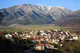 View from Achladochori | |
 Achladochori Location within the regional unit 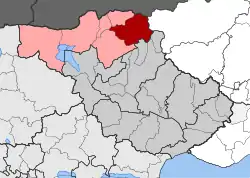 | |
| Coordinates: 41°19′N 23°33′E | |
| Country | Greece |
| Administrative region | Central Macedonia |
| Regional unit | Serres |
| Municipality | Sintiki |
| • Municipal unit | 187.0 km2 (72.2 sq mi) |
| Population (2011)[1] | |
| • Municipal unit | 861 |
| • Municipal unit density | 4.6/km2 (12/sq mi) |
| Community | |
| • Population | 680 (2011) |
| Time zone | UTC+2 (EET) |
| • Summer (DST) | UTC+3 (EEST) |
| Vehicle registration | ΕΡ |
Near Achladochori there was an ancient city (probably the city of Tristolos), whose ruins has been found on the hill "Gradista", located 4 km north-east of the village. [4]
References
- "Απογραφή Πληθυσμού - Κατοικιών 2011. ΜΟΝΙΜΟΣ Πληθυσμός" (in Greek). Hellenic Statistical Authority.
- Kallikratis law Greece Ministry of Interior (in Greek)
- "Population & housing census 2001 (incl. area and average elevation)" (PDF) (in Greek). National Statistical Service of Greece. Archived from the original (PDF) on 2015-09-21.
- Archived 2017-04-24 at the Wayback Machine D. C. Samsaris, Historical Geography of Eastern Macedonia during the Antiquity (in Greek), Thessaloniki 1976 (Society for Macedonian Studies), p. 125. ISBN 960-7265-16-5
This article is issued from Wikipedia. The text is licensed under Creative Commons - Attribution - Sharealike. Additional terms may apply for the media files.
