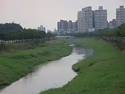
Agongdian River
The Agongdian River (Chinese: 阿公店溪; pinyin: Āgōngdiàn Xī; Pe̍h-ōe-jī: A-kong-tiàm-khe) is a river in Taiwan.[1]
| Agongdian River | |
|---|---|
 | |
| Native name | 阿公店溪 (Chinese) |
| Location | |
| Location | Kaohsiung, Taiwan |
| Physical characteristics | |
| Source | |
| • coordinates | 22°48′38.3″N 120°20′38.2″E |
| Mouth | |
• coordinates | 22°48′13.2″N 120°12′52.9″E |
| Length | 38 km |
| Basin size | 137 km2 |
Name
Indigenous people who resided in the area called it Agongtoan. Min Chinese speakers from Fujian changed the pronunciation to "a-kong tiàm" (grandpa's shop), and used it for both Gangshan District, as well as the Agongdian River. Efforts to dam the river began in 1942, when Taiwanese was under Japanese rule. However, flood damage resulted in the suspension of the project, which was completed in 1953. The river now shares its name with the completed reservoir and Agongdian Forest Park.[2]
Geology
The river flows through Kaohsiung for 38 km[3] from Agongdian Reservoir in Yanchao District.[4][5]
Transportation
The river is accessible within walking distance North of Gangshan South Station of Kaohsiung MRT.
See also
References
- "Agongdian River". Water Resources Agency, MOEA. 21 November 2018. Retrieved 13 May 2019.
- Crook, Steven (20 December 2019). "Highways and Byways: Going around in circles at Agongdian Reservoirs". Taipei Times. Retrieved 20 December 2019.
- "Geography & demographics". The Republic of China Yearbook 2015. Executive Yuan. 2015. pp. 40–53. ISBN 978-986-04-6013-1. Archived from the original on 2016-05-31. Retrieved 2016-05-01.
- ◎Photos by Pao Chung-hui. "Waterside Cycling Path Circumnavigating the Agongdian Reservoir/????? ?????? (Kaohsiung City Government) - Worldnews.com". Article.wn.com. Retrieved 2014-05-25.
- "Reservoirs, dams and weirs of Taiwan". Water Resources Agency, Ministry of Economic Affairs. 26 June 2013. Archived from the original on 13 May 2016. Retrieved 1 May 2016.
| Wikimedia Commons has media related to Agongdian River. |