Agrate Conturbia
Agrate Conturbia (Piedmontese: Agrà e Contòrbia, Lombard: Agraa e Contorbia) is a comune (municipality) in the Province of Novara, in the Italian region of Piedmont, located about 100 kilometres (62 mi) northeast of Turin and about 25 kilometres (16 mi) north of Novara. It consists of two towns, Agrate and Conturbia, located in the low hills between Cressa and Borgo Ticino, south of Lake Maggiore.
Agrate Conturbia | |
|---|---|
| Comune di Agrate Conturbia | |
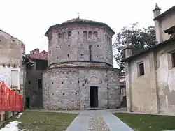 The Romanesque baptistery | |
Location of Agrate Conturbia 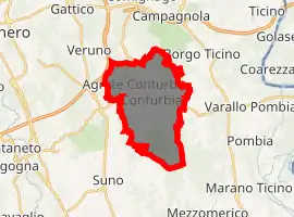
| |
 Agrate Conturbia Location of Agrate Conturbia in Italy 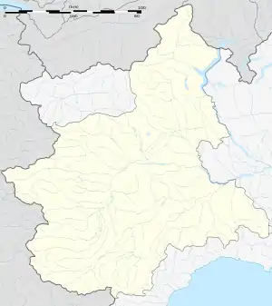 Agrate Conturbia Agrate Conturbia (Piedmont) | |
| Coordinates: 45°40′35″N 8°33′08″E | |
| Country | Italy |
| Region | Piedmont |
| Province | Novara (NO) |
| Frazioni | Agrate, Conturbia |
| Government | |
| • Mayor | Simone Tosi |
| Area | |
| • Total | 14.51 km2 (5.60 sq mi) |
| Elevation | 337 m (1,106 ft) |
| Population | |
| • Total | 1,544 |
| • Density | 110/km2 (280/sq mi) |
| Demonyms | Agratesi, Conturbiesi |
| Time zone | UTC+1 (CET) |
| • Summer (DST) | UTC+2 (CEST) |
| Postal code | 28010 |
| Dialing code | 0322 |
| Website | Official website |
Agrate Conturbia borders the following municipalities: Bogogno, Borgo Ticino, Divignano, Gattico-Veruno, Mezzomerico and Suno.
Main sights
- Castle of Agrate, of which few original parts remain after it was damaged in 1400
- Castle of Coturbia, also modified
- Parish church of San Vittore, documented as early as 978
- Baptistry of Agrate, in Romanesque style. It is dedicated to St. John the Baptist. The lower section (based over a Roman edifice) dates to about 930, while the upper one is from about 1120. It has an octagonal plan, with a small portal surmounted by a single mullioned window. Further triple, blind mullioned windows decorate each face of the building, as well as Lombard bands. The interior has some 15th-century frescoes.
- Faunistic Park La Torbiera, a zoo built in 1977
References
- "Superficie di Comuni Province e Regioni italiane al 9 ottobre 2011". Istat. Retrieved 16 March 2019.
- All demographics and other statistics: Italian statistical institute .
- "Popolazione Residente al 1° Gennaio 2018". Istat. Retrieved 16 March 2019.
External links

| Authority control |
|
|---|
This article is issued from Wikipedia. The text is licensed under Creative Commons - Attribution - Sharealike. Additional terms may apply for the media files.