Aira Caldera
Aira Caldera is a gigantic volcanic caldera that is located on the southern end of Kyushu, Japan. It is believed to have been formed over 22,000 years ago from a succession of pyroclastic surges. It is currently the place of residence to over 900,000 people. Additionally, Aira Caldera is home to unique and various flora and fauna that has acclimatised to its environment, including the Machilus Thunbergii and Japanese Black Pine (“Relationship with Nature”, n.d.). The caldera is also home to Mount Kirishima, a group of stratovolcanoes at the northern end of the caldera. The most famous and active of the Mount Kirishima volcanoes is Shinmoedake.
| Aira | |
|---|---|
| 姶良カルデラ | |
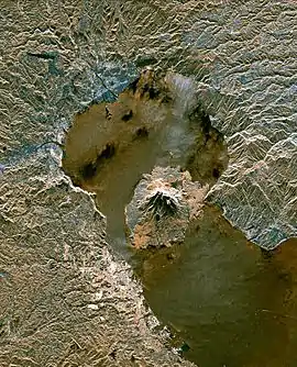 Radar image from a space shuttle of Aira Caldera in 1999, with Sakurajima in the bay formed by the caldera | |
| Highest point | |
| Elevation | 1117 m |
| Coordinates | 31°40′01″N 130°40′01″E |
| Geography | |
| Geology | |
| Age of rock | 22,000 years old |
| Mountain type | Caldera Somma volcano |
| Last eruption | 2021 |
Aira Caldera has an underlying magmatic chamber that connects with the Kirishima magmatic system. This has enabled magma from the Caldera to feed into the stratovolcano Sakurajima, causing it to expand over time. Thus, Sakurajima has caused a series of disasters such as the eruption in 1914 which killed 58 people (University of Bristol,. (2016)) and sank the magma chamber by 60cm (Remy et al., 2007)
History
Location
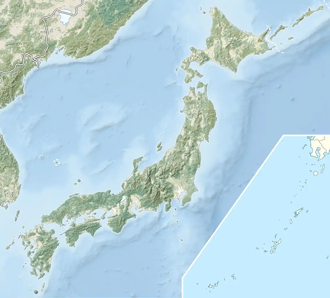
Aira caldera is located at Kyushu, the southernmost island of Japan. The supervolcano peaks at 1117m3 (Aira, Japan, n.d.). It is Japan’s most active caldera with hundreds of minor eruptions from its volcanoes occurring each year.
The first major eruption, from approximately 22,000 years ago, resulted in a vast amount of magma denting the nearby land. This was how Aira caldera was created. The eruption also aided in the formation of the 200m deep Kinko Bay which formed after sea water entered the area. (“About Us”, n.d)
Aira caldera is surrounded by the major city of Kagoshima which has a population >900,000. Residents do not mind small eruptions because they have measures in place for protection. For example, school students are required to wear hard helmets for protection against falling debris (“About Us”, n.d). Additionally, a disaster prevention system with the world’s best high-tech volcanic monitory system was put in place. The Caldera is now closely monitored by the Sakurajima Volcano Research Centre which is a part of the University of Kyoto and Disaster Prevention Research Institute (“Aira Caldera”, n.d.). This ensures the safety of the residents and provides a peaceful coexistence with the people of Kagoshima and the active caldera.
Geological Background
Aira Caldera was created 22,000 years ago after a large scale of pyroclastic surges. The eruption of the Caldera assisted in its formation creating its total area of 17 x 23km. The formation of Aira Caldera started with a Plinian Pumice Eruption and was quickly followed by an oxidised Tsumaya pyroclastic flow (Aramaki, S. 1984). Basement rock fragments and pumiceous materials from a violent explosion formed the Ito pyroclastic flow about 300km3 in volume (Aramaki, S. 1984). The Caldera is known for its gravitational anomalies which have caused a funnel-like shape in the strata.
It is believed that the reason for the large-scale vent area is because the caldera experienced over 140km3 of magma in a short amount of time (Aramaki, S. 1984). However evidence for the creation of the vent area is difficult to contain because most of the evidence is under water.
The structure of the Caldera is known for its uniqueness. It is different from the typical Valles-type Caldera whose defining characteristics include a ring fracture which acts as a channel for a large-scale pyroclastic flow (Aramaki, S. 1984). Aira Caldera has no such evidence for a Valles-type ring fracture.
Before the initial eruption 22,000 years ago there was a ‘wide and shallow basin nearly the same size of present Aira caldera [which] occupied the northern end of the Bay with an east-west ride’ (Aramaki, S. 1984). The basin is separated from the rest of the bay by a ridge which is 300-500m above sea level. The topography encompasses the outline of an older caldera hence creating the assumption that there was a pyroclastic flow that predated the formation of present day Aira caldera.
The eruption activity dates of Aira caldera were roughly between “34,500 years B.P and 16,500 years B.P (Sato et al., 1972)”(Aramaki, S. 1984). The first phase of activity was the Osumi Pumice Fall (named because the pumice fall extended across the Osumi peninsula). This reacted to a large Plinian column and distributed pumice and ash beds over southern Kyushu. However, this lacks stratification. The Osumi Pumice Fall is mainly homogeneous ‘except for an overall reverse grading’ (Aramaki, S. 1984).
Above the Osumi pumice fall deposit, the Tsumaya pyroclastic flow deposit occurred. It is considered interesting for contrasting the Ito pyroclastic flow because it is wholly confined within the pre-Aira basin. The Ito pyroclastic flow extends outside the basin as well as occupying inside the basin.
The Tsumaya pyroclastic flow buried the pre-Aira topography such as box canyons (formed by older pyroclastic flow deposits). The maximum thickness of the caldera is 130m in the Kokubu area with the average thickness being 30m or less (Aramaki, S. 1984). The Tsumaya pyroclastic flow consisted of a ‘pale pinkish brown glass matrix containing a small amount of pumice and lithic fragments’ (Aramaki, S. 1984) which suggests that the Osumi pumice fell and the Tsumaya pyroclastic flow occurred from the same vent. There was only a ‘geologically very short pause’ (Aramaki, S. 1984) between the Tsumaya pyroclastic flow and the beginning of the formation of the caldera.
Volcanic Activity
The relationship between Aira and Kirishima Magmatic systems
Aira caldera is one of the most active and hazardous calderas in the world. It is home to the Kirishima volcanoes, a group of active volcanoes at the north end of Aira caldera. One of these volcanoes, Shinmoedake, has produced two strong magneto-phreatic eruptions, separated by almost 300 years. Starting in December 2009, active diving and inflation before the outbreak were noticed. A series of sub-plinian events then occurred from January 19th to the 31st (Brothelande E., et al, 2018). The first phase (eruption climax) was accompanied by a strong co-eruptive deflation.
Aira Caldera may respond to small eruptions that come from a common reservoir. However, not all the volcanic systems are connected all the time as magma pathways open and close. The connection between Aria and Kirishima represents the clearest example of volcano interconnectivity revealed by geodetic monitoring. The inflation of one volcano can enhance the eruption probability of a neighbouring volcano. The subduction of the Philippine sea plate beneath the Eurasian plate is the reason for the active volcanism (Brothelande E., et al, 2018).
Aira Caldera and Kirishima’s magma storage is linked through tunnels that extend horizontally over tens of kilometers which is able to be explained through the presence of hotspots (Brotherlande, et al,. 2018). However, the volcanic systems are not always connected since the magma pathways open and close. For example, the Shinmoedake vertical connection was closed for approximately 300 years until reactivation.
The changes in volume for the Aira and Kirishima systems suggest they had different inflation and deflation periods. Between 2009 and 2013, there was evidence of inflation in the Aira system. However, after the 2011 eruption at Kirishima, the Aira system experienced a deflation. This was Aira caldera’s only deflation between 2009 and 2013 (Brothelande E., et al, 2018).
Inflation of Aira Caldera
The magma storage underlying Aira caldera has been feeding into the stratovolcano Sakurajima, expanding over time. However, there have been points in time where the chamber has deflated as a result of eruptions releasing the pressure built which cannot be explained by stress changes. Thus, it has been described as a consequence of magma withdrawing from the Aira system when Kirishima was replenishing. A prime example is the Sakurajima eruption in 1914 (approximately 1.5km3 in volume), which caused the magma chamber to sink 60cm. 58 people were killed in the eruption (University of Bristol, 2016). For this amount of magma to erupt, it would take approximately 130 years for the chamber to refill as according to Dr James Hickey and his co-authors. Dr Hickey stated "These results were made possible by combining data from various monitoring methods and applying them to new numerical modelling techniques, moving away from older modelling methods that have been in use since the 1950s.” (University of Bristol, 2016).
Nevertheless, there are continuous measurements of the ground movement that indicate the area is now inflating. Recent GPS deformation measurements, amalgamated with geophysical data and computer modelling enable the reconstruction of the magma system beneath the caldera. Through this, Dr James Hickey and his co-authors were able to create a depiction of the tunnels beneath the caldera.
They discovered that magma is filling the magma chamber at a faster rate than the Sakurajima volcano erupts. The reservoir is expanding each year as a volume of 14 million m3 is supplied to the system (University of Bristol, 2016). Dr Haruhisa Nakamichi, Associate Professor at the Disaster Prevention Research Institute, Kyoto University, and co-author, said: "It is already passed by 100 years since the 1914 eruption, less than 30 years is left until a next expected big eruption, Kagoshima city office has prepared new evacuation plans from Sakurajima, after experiences of evacuation of the crisis in August 2015." (University of Bristol, 2016)
A group of scientists led by Dr Dominique Remy used Synthetique Aperture Radar (SAR) to detect levels of inflation of Aira Caldera over the Kokubu urban district. They observed a change in the pattern of Kokubu’s surface. Through a model of the deformation field of the caldera, it is predicted there is ‘a maximum volume increase of 203- x 106m3 between 1995 and 1998. They deduced an inflation of approximately 70mm at the centre of the caldera and 40mm in the south urban area of Kokubu (Remy D., 2007).
Botany and Wildlife
The botany of Aira caldera is capable of regrowth after an eruption. The Machilus Thunbergii and Japanese Black Pine are two species which grow furthest away from the centre of the caldera. These plants are able to repopulate; however they cannot withstand the debris and pumice after an eruption. The Eurya japonica and Alnus firma can be found in the middle ground between the furthest point of the caldera and its peak. They are able to grow back from an eruption and withstand its destruction more than the vegetation furthest away. At the peak of the caldera, the Japanese Pampas grass and Knotweed are located. They respond quickly after an eruption and form a meadow of mosses and lichens during regrowth. Nevertheless, It takes many years for the forest to regrow. This enables people to observe the changes of vegetation from the different eruptions in different eras.
Kinko Bay is located in Kagoshima near the Sakurajima volcano. It is home to many wildlife; including 1000 different species of fish as well as rare creatures such as the Satsumahaorimushi (“About us”, n.d.). At the bottom of the sea, there are rare metals and a chimney that can be found. Kinko Bay is well known for wild dolphins to frequently populate the area and is a current tourist attraction.
References
- "About Us". (n.d.). Retrieved from http://www.sakurajima-kinkowan-geo.jp/en/en-sakurajima-kinkowan/
- Aira Caldera. (n.d.). Retrieved April 24, 2020, from https://comet.nerc.ac.uk/volcanoes/aira/
- Aramaki, S. (1984). Formation of the Aira Caldera, southern Kyushu ~ 22,000 years ago. Journal of Geophysical Research: Solid Earth, 89(B10), 8485–8499. doi: 10.1029/jb089ib10p08485
- Brotherlande, E., Amelung, F., Yunjun, Z., & Wdowinski, S. (2018). Geodetic evidence for interconnectivity between Aira and Kirishima magmatic systems, Japan. Scientific Reports, 8, 1–8. doi: 10.1038/s41598-018-28026-4
- Relationship with Nature. (n.d.). Retrieved from http://www.sakurajima-kinkowan-geo.jp/en/en-sakurajima-kinkowan/
- Remy, D., Bonvalot, S., Murakami, M., Briole, P., & Okuyama, S. (2007). Inflation of the Aira Caldera (Japan) detected over Kokubu urban area using SAR interferometry ERS data. eEarth, 2(1), 18–24. DOI: 10.5194/ee-2-17-2007REmy
- Supervolcano. (n.d.). Retrieved April 24, 2020, from http://www.earthlyissues.com/supervolcano.htm
- University of Bristol, "Magma accumulation highlights growing threat from Japanese volcanoes," https://phys.org/news/2016-09-magma-accumulation-highlights-threat-japanese.html, 2016
