Airport Connector (Harrisburg)
The Airport Connector is a 1.9-mile-long (3.1 km) freeway in the Harrisburg, Pennsylvania, area in the Commonwealth of Pennsylvania. It begins at Harrisburg International Airport and runs north to Pennsylvania Route 283 (PA 283). There is one intermediate interchange with PA 230.
| Airport Connector | |
|---|---|
 | |
| Route information | |
| Maintained by PennDOT | |
| Length | 1.940 mi[1] (3.122 km) |
| Existed | 1977–present |
| Major junctions | |
| South end | |
| North end | |
| Location | |
| Counties | Dauphin |
| Highway system | |
| |
The highway is one of only two freeways in Pennsylvania with no posted route number (the other being the Central Scranton Expressway). In the Location Referencing System, it is designated State Route 3032 by the Pennsylvania Department of Transportation.
Route description

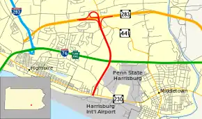
The Airport Connector begins at the entrance to Harrisburg International Airport in Lower Swatara Township, Dauphin County, where the roadway continues south to loop around the terminal. Past the airport, the road passes over Amtrak's Keystone Corridor before immediately reaching a folded diamond interchange with PA 230. From this point, the four-lane freeway heads north-northeast through wooded areas adjacent to homes and farms, crossing over the Pennsylvania Turnpike (I-76) without an interchange as it curves north-northwest. The freeway passes more areas of farms and woods before it reaches its terminus at a trumpet interchange with PA 283. The interchange also provides partial access between PA 283 and PA 441, but the Airport Connector has no connection to the latter route.[2]
History
With the opening of PA 283 in 1972 and the completion of new terminals at Harrisburg International Airport the following year, a need was determined to provide a direct connection between the two, as the airport was not served by the area's freeway system. Construction began in 1974 and the connector opened to traffic in 1977.[3]
The connector is notable in Pennsylvania for having a large amount of button copy signage dating to the construction of the road.
Exit list
The entire road is in Lower Swatara Township, Dauphin County. All exits are unnumbered.
| mi[1] | km | Destinations | Notes | ||
|---|---|---|---|---|---|
| 0.000 | 0.000 | Southern terminus; also provides access to Airport Drive | |||
| 0.261 | 0.420 | Access to Penn State Harrisburg | |||
| 1.940 | 3.122 | Northern terminus | |||
| 1.000 mi = 1.609 km; 1.000 km = 0.621 mi | |||||
See also
 U.S. Roads portal
 Pennsylvania portal
References
- Bureau of Maintenance and Operations (January 2015). Roadway Management System Straight Line Diagrams (Report) (2015 ed.). Pennsylvania Department of Transportation. Retrieved June 30, 2015.
- Dauphin County (PDF)
- Google (2010-12-24). "overview of Airport Connector" (Map). Google Maps. Google. Retrieved 2010-12-24.
- Jeffrey J. Kitsko (March 31, 2010). "Harrisburg Highways: Airport Connector". Pennsylvania Highways. Retrieved September 29, 2018.