Harrisburg International Airport
Harrisburg International Airport (IATA: MDT, ICAO: KMDT, FAA LID: MDT) is a public airport in Middletown, Pennsylvania, United States,[4] nine miles (15 km) southeast of Harrisburg. It is owned by the Susquehanna Area Regional Airport Authority.[5]
Harrisburg International Airport | |||||||||||
|---|---|---|---|---|---|---|---|---|---|---|---|
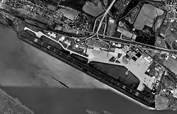 USGS 1999 orthophoto | |||||||||||
| Summary | |||||||||||
| Airport type | Public | ||||||||||
| Owner/Operator | Susquehanna Area Regional Airport Authority | ||||||||||
| Serves | Harrisburg, Pennsylvania | ||||||||||
| Location | Middletown, Pennsylvania | ||||||||||
| Hub for | Wiggins Airways[1] | ||||||||||
| Elevation AMSL | 310 ft / 94 m | ||||||||||
| Coordinates | 40°11′35″N 076°45′48″W | ||||||||||
| Website | www.FlyHIA.com | ||||||||||
| Maps | |||||||||||
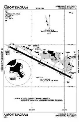 FAA airport diagram | |||||||||||
 MDT Location of airport in Pennsylvania  MDT MDT (the United States) | |||||||||||
| Runways | |||||||||||
| |||||||||||
| Statistics (2017) | |||||||||||
| |||||||||||
The airport code MDT refers to Middletown, the town in which the airport is located. Planes landing at MDT from the south are often routed near Three Mile Island a few miles from the airport. The airport, frequently referred to as HIA, is the primary commercial airport in South Central Pennsylvania and is the third-busiest airport in Pennsylvania for passenger enplanements and cargo shipments behind Philadelphia International Airport and Pittsburgh International Airport.[6][7]
History
Harrisburg International Airport has been serving south-central Pennsylvania for over 100 years.[8] Beginning in 1898, the Signal Corps of the U.S. Army was stationed here. This was followed by the first military airplanes landing in 1918 at what had become Olmsted Field of the fledgling U.S. Army Air Service.
The Middletown Air Depot (later Middletown Air Materiel Area) at Olmsted provided logistical and maintenance support of military aircraft until it closed in 1969. In 1968 airline flights moved from Capital City Airport to the former Air Force base, renamed as Olmstead State Airport. The airport was renamed Harrisburg International Airport in 1973.[9] Architect William Pereira designed the new terminals, completed in 1973.
In 1998 the Commonwealth transferred ownership to the Susquehanna Area Regional Airport Authority (SARAA). The Authority board consists of community volunteers appointed to staggered, five-year terms by the elected officials from Cumberland, Dauphin, and York counties, the cities of Harrisburg and York, and Fairview and Lower Swatara townships.
About 1,400 people work in the system of Harrisburg International Airport.[10]
A new 360,000 square-foot terminal was completed in 2004. It cost $120 million and was designed by the Sheward Partnership.[11]
Facilities and aircraft
Harrisburg International Airport covers 680 acres (280 ha) at an elevation of 310 feet (94 m) above mean sea level. It has one asphalt runway, 13/31, 10,001 by 200 feet (3,048 by 61 m).[5]
Runway 13 has a CAT III approach allowing operations down to 600 feet (180 m) RVR (Runway Visual Range). The airport has a Surface Movement Guidance Control System (SMGCS) that allows aircraft and vehicle ground movements during reduced visibility (below 1,200 feet (370 m) RVR down to 600 feet (180 m) RVR).

The airfield also boasts a 140-foot control tower and associated approach control manned and operated by FAA air traffic controllers.
In 2005 the airport had 71,190 aircraft operations, an average of 195 per day: 54% air taxi, 22% general aviation, 13% scheduled commercial and 12% military. 29 aircraft were then based at this airport: 17% single-engine, 28% multi-engine, 31% jet, 3% helicopter and 21% military.[5]
The terminal has 12 gates and is a pier finger lay out near the middle of the airfield, almost parallel to the runway. Gates B2 and B4 are not in use. Delta Air Lines uses A1-A3. United Airlines uses B1 & B3. Frontier Airlines uses B5. Allegiant Air uses B6. American Airlines uses C1-C3.[12]
Ground transportation
Built in 2004, and attached to the new terminal building via a climate-controlled sky bridge, the Multi-Modal Transportation Facility (MMTF) is a four-story facility that handles all ground transportation. The top three levels have 2,504 parking places for Short-Term Hourly, Daily, and Long-Term public parking. The first level accommodates all limos, taxis, hotel shuttles, public and charter buses, plus the rental car ready/return lot.[13]
In the first floor lobby area are six rental car counters, restrooms, flight, and bus information displays, and a seating area. On the second floor of the lobby area, climate-controlled moving sidewalks connect to the aerial walkway to the terminal.[13]
Route 7 of the Capital Area Transit System runs to downtown Harrisburg and surrounding communities. The Middletown Amtrak Station, about 3 miles (5 km) east of the terminal, has Amtrak service via the Keystone corridor. There had been a proposal to construct a new rail terminal adjacent to the MMTF, but the final location chosen for the new station is about 2 miles (3.2 km) east, in Middletown.[14]
Airlines and destinations
Passenger
Cargo
Harrisburg International Airport has freight-forwarding capability. The airport is next to I-76 (Pennsylvania Turnpike), I-83, and I-81, allowing fast transfer of goods. Three major air cargo shippers maintain air service at the east end of the airport in an apron area next to the runway:[20]
| Airlines | Destinations |
|---|---|
| DHL Aviation | Cincinnati Seasonal: Hartford |
| FedEx Express | Baltimore, Greensboro, Indianapolis, Memphis, Pittsburgh, Syracuse, Washington–Dulles Seasonal: Hartford |
| FedEx Feeder | Newark, Williamsport, Wilkes–Barre/Scranton[21] |
| UPS Airlines | Louisville, Miami, Philadelphia, Portland (OR) Seasonal: Chicago/Rockford, Hartford |
| Passenger destinations map |
|---|
 Harrisburg Passenger destinations from Harrisburg International Airport Red = Year-round destination Green = Seasonal destination |
| Cargo destinations map |
|---|
Harrisburg Cargo destinations from Harrisburg International Airport Red = Year-round destination Green = Seasonal destination |
Statistics
Top destinations
| Rank | City | Passengers | Carriers |
|---|---|---|---|
| 1 | Charlotte, North Carolina | 85,070 | American |
| 2 | Chicago–O'Hare, Illinois | 70,680 | American, United |
| 3 | Atlanta, Georgia | 40,970 | Delta |
| 4 | Philadelphia, Pennsylvania | 36,550 | American |
| 5 | Detroit, Michigan | 28,860 | Delta |
| 6 | Orlando–Sanford, Florida | 27,880 | Allegiant |
| 7 | Washington–Dulles, D.C. | 22,620 | United |
| 8 | Punta Gorda, Florida | 15,450 | Allegiant |
| 9 | St. Petersburg/Clearwater, Florida | 15,060 | Allegiant |
| 10 | Dallas/Fort Worth, Texas | 14,760 | American |
Annual traffic
| Passengers | Change from previous year | Cargo (tons) | |
|---|---|---|---|
| 2013 | 1,294,632 | 54,344 | |
| 2014 | 1,289,487 | 48,922 | |
| 2015 | 1,173,938 | 51,401 | |
| 2016 | 1,205,461 | 52,807 | |
| 2017 | 1,195,763 | 51,886 | |
| 2018 | 1,294,765 | 57,303 |
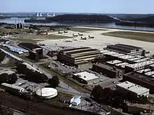
Pennsylvania Air National Guard use
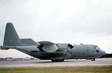
Despite the closure of Olmsted AFB in 1969, the US Air Force continues an Air National Guard presence at Harrisburg[24] in the form of Harrisburg Air National Guard Station and the Pennsylvania Air National Guard's 193rd Special Operations Wing (193 SOW), an Air Force Special Operations Command (AFSOC)-gained unit flying the EC-130 Commando Solo aircraft. The 193 SOW is the sole operator of this critical aircraft asset for the entire US Air Force and in 2001 transitioned from the EC-130E to the new EC-130J variant. The wing has seen extensive Federal service in recent years in support of Operations Just Cause, Desert Storm, Enduring Freedom and Iraqi Freedom.
Harrisburg International Airport remains an active touch and go practice runway for SAM 28000 and SAM 29000. These two planes carry the President. They are also known as Air Force One, the call that is adopted when the president is aboard either aircraft (or any other Air Force aircraft for that matter). The Air Force pilots use the custom VC-25's (Boeing 747s) to practice via touch and go at the airport. These practice runs are at random (for obvious security reasons), but they do tend to be seen about weekly. The Air Force uses MDT as the practice airport for a number of reasons: its runway is long enough for a loaded 747, relatively low traffic, close proximity to Andrews Air Force Base, and the presence of the Air National Guard at MDT.
See also
References
- https://wiggins-air.com/route-map/
- "Passenger and Operational Statistics" (PDF). Retrieved February 19, 2016.
- "Harrisburg Intl". AirportIQ 5010. Retrieved February 19, 2016.(Location Identifier: MDT)
- "Lower Swatara township, Dauphin County, Pennsylvania Archived June 6, 2011, at the Wayback Machine." U.S. Census Bureau. Retrieved on March 2, 2010.
- FAA Airport Form 5010 for MDT PDF, effective June 5, 2008
- "Commercial Service Airports by State and Type of Carrier" (PDF). Federal Aviation Administration. 2007. Retrieved July 4, 2007.
- "Airports Reporting All-Cargo Data for Calendar Year 2005" (PDF). Federal Aviation Administration. 2007. Retrieved July 4, 2007.
- "Harrisburg International Airport History". Archived from the original on December 22, 2008.
- "National Oil and Hazardous Substances Pollution Contingency Plan National Priorities List" (PDF). Federal Register. 62 (100): 28408. May 23, 1997. Retrieved April 11, 2018.
- Airport Authority History Archived December 22, 2008, at the Wayback Machine SARAA, accessed February 14, 2010.
- "The Sheward Partnership – Harrisburg International Airport". Archived from the original on February 12, 2008.
- FAA Airport Diagram for Harrisburg International (MDT) (PDF), effective January 28, 2021
- Multi-Modal Transportation Facility Archived February 21, 2010, at the Wayback Machine SARAA, accessed February 12, 2010.
- "New Middletown Amtrak station site will be at Ann Street and Route 230".
- "Allegiant Air". Retrieved April 5, 2017.
- "Flight schedules and notifications". Retrieved April 5, 2017.
- "FLIGHT SCHEDULES". Retrieved April 5, 2017.
- "Nonstop Route Map". Retrieved December 2, 2020.
- "Timetable". Retrieved April 5, 2017.
- Cargo operations at HIA Archived February 11, 2011, at the Wayback Machine Harrisburg International Airport, accessed March 4, 2010.
- "Wiggins #7450 ✈ 15-Feb-2018 ✈ KAVP - KMDT ✈ FlightAware". FlightAware.
- "RITA – BTS – Transtats".
- "Stats". Harrisburg International Airport. Retrieved February 16, 2018.
- Burger, T.W. (June 21, 2010). "Pennsylvania Air National Guard unit called rescuers on wings". Harrisburg Patriot News. Retrieved December 17, 2010.
External links
- Harrisburg International Airport (official site)
- Harrisburg International Airport at Pennsylvania Bureau of Aviation
- FAA Airport Diagram (PDF), effective January 28, 2021
- FAA Terminal Procedures for MDT, effective January 28, 2021
- Resources for this airport:
- AirNav airport information for KMDT
- ASN accident history for MDT
- FlightAware airport information and live flight tracker
- NOAA/NWS weather observations: current, past three days
- SkyVector aeronautical chart for KMDT
- FAA current MDT delay information