Alabama State Route 177
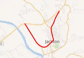
State Route 177 (SR 177) is a 5.160-mile-long (8.304 km) route in Jackson in the southwestern part of the state. Bothis its southern and northern termini are at separate intersections with US 43 in Jackson.
| ||||
|---|---|---|---|---|
| ||||
| Route information | ||||
| Maintained by ALDOT | ||||
| Length | 5.160 mi[1] (8.304 km) | |||
| Major junctions | ||||
| South end | ||||
| North end | ||||
| Location | ||||
| Counties | Clarke | |||
| Highway system | ||||
| ||||

Route description
Prior to 1970, US 43 passed through Jackson. With the completion of a by-pass to the west of the city, US 43 was moved to the new roadway, and SR 177 was designated along the former U.S. Highway. SR 177 also serves as the southern terminus of SR 69, one of the longest state routes in Alabama.[2]
Major intersections
The entire route is in Jackson, Clarke County.
| mi[1] | km | Destinations | Notes | ||
|---|---|---|---|---|---|
| 0.000 | 0.000 | Southern terminus | |||
| 3.771 | 6.069 | Southern terminus of SR 69 | |||
| 5.160 | 8.304 | Northern terminus | |||
| 1.000 mi = 1.609 km; 1.000 km = 0.621 mi | |||||
References
- Alabama Department of Transportation. "Milepost Maps". Archived from the original on July 27, 2011. Retrieved April 2, 2011.
- Google (July 25, 2016). "Alabama State Route 177" (Map). Google Maps. Google. Retrieved July 25, 2016.
External links
This article is issued from Wikipedia. The text is licensed under Creative Commons - Attribution - Sharealike. Additional terms may apply for the media files.